
-
 14745 Hits
-
 73.06% Score
-
 3 Votes
|
|
Trailhead |
|---|---|
|
|
48.46700°N / 113.88436°W |
|
|
Flathead |
|
|
Spring, Summer, Fall, Winter |
|
|
3380 ft / 1030 m |
Ousel Peak Trailhead Overview:
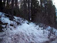
 Trailhead Sign
This trailhead gives access to the Great Bear Wilderness which lies in the Flathead Mountain Range
U.S. Highway 2 follows the Middle Fork of the Flathead River as it forms the boundary of the southwestern side of Glacier National Park and actually passes through a small portion of the park to the East of Essex, Montana. Just east of the park U.S. Highway 2 follows Bear Creek to Marias Pass. Marias Pass was influential for the Transcontinental Railroad and was “discovered” by John Stephens as he search for a rail route through the mountains.
Mountains Accessed from the Trailhead:
Ousel Peak
Accessing the Trailhead:
 Trailhead
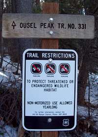 Trailhead Sign
Directions to the trailhead:
The trailhead is located about half way between mile marker # 159 and #160 on U.S. Highway 2 between an area called Nyack Flats and West Glacier. Montana.
The parking area for this trailhead is on Highway 2.
If traveling from the East the “Ousel Pk” sign will be seen and there is a parking area about 100 yards beyond the sign on the right side (river side) of the road.
If traveling from the West look for the #159 mile marker and begin looking for a pull-out on the left side (river side) of the highway.
There should be ample parking for your vehicle as this is not a busy trailhead. If for some reason there is no parking there is a BNSF Service Road just beyond the “Ousel PK” sign and you might be able to park there as well. Please avoid blocking the road as it is frequently used by BNSF employees to access the rail line.
Other Information:
 View across highway
The USGS quad maps associated with this area are Nyack and West Glacier.
Get a Glacier National Park map from a local sporting goods store or locate them here at 7.5 Minute Topo Maps for Glacier National Park and then download them for free.
There may be little water on this route after leaving the valley floor.
This is bear country! Bring bear spray and know how to use it.
As with all hiking and climbing in Glacier National Park use caution and practice good manners with the wildlife. You are in bear country. Carry bear deterrent spray, don’t hike alone and make some noise. For more information please go to the Park's web site for Bear Information. The U.S. Forest Service also has helpful information on Grizzly Bear Management.