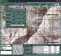
TopoFushion
| Page Type | Gear Review |
|---|---|
| Object Title | TopoFushion |
| Manufacturer | Microsoft |
| Page By | redsplashman23 |
| Page Type | Jan 25, 2007 / Jan 25, 2007 |
| Object ID | 2069 |
| Hits | 4287 |
| Vote |
Product Description
TopoFusion is GPS Mapping software created by Microsoft for Windows Operating Systems. You can download maps (Aerial Photo, Satellite, and Topo) from Microsoft's TerraServer and NASA's OnEarth server. You then can store them on your hard drive for later offline use.You can download the free version. The only problem with this is that 1/3rd of the map tiles are covered with "DEMO" accross them. To remove this you can register the software for $40.
Features
New in Version 2.85- 3D terrain visualization
- Support for Garmin USB devices, including X-series units (60CSx, LegendCx) and new generation Edge/Forerunner units
- Color aerial photographs for urban areas
- GPS dialog allows saving/merging of tracks files for each download.
Display features
- Displays USGS Topographical Quadrangle Maps in realtime downloads from Terraserver.
- Good panning and zooming of maps.
- Combines the use of topo and aerial maps using Alpha Blending.
- Uses Image Processing Dialog which adjust brightness, contrast, sharpness and blurring for aerial, topo, and combo maps.
- Stores downloaded maps onto your local hard drive for later off-line use.
GPS compatibility
- Downloads and Uploads waypoints to and from Garmin and Magellan Receivers.
- Supports real time tracking of GPS position for any NMEA compatible GPS unit as well as Garmin's protocol.
Data Export
- Reads and writes using the GPX (GPS Exchange) XML format.
- Imports and Exports track and waypoint files from Delorme Topo USA and Maptech Terrain Navigator (.txt, .txf, .mxf)
- Exports maps (with track/waypoint overlay) to .BMP and .JPG formats. Worldfile export is also available.
Data Analysis
- Computes trip reports: distance traveled, total trip time, elevation climbing/loss, average speed, Pace (minutes per mile), Moving time, stopped time, uphill time, downhill time, flat time, up/down/flat distance, average uphill/downhill grade, and max speed.
- Produces shaded elevation profiles for tracks and trail network segments.
- Draws tracks using elevation shading.
- Trip playback mode replays your trip in real time showing position and statistics of trips as time progresses.
- Multi-Track playback offers many varieties of trip visualizations and comparison options.
- Supports 9 map datums including NAD 27, WGS 72, WGS 84, and Ordinance Survey.
Future Features
Images

redsplashman23 - Feb 20, 2007 2:37 am - Hasn't voted
Topo Fusion