
|
|
Route |
|---|---|
|
|
37.97890°N / 105.5976°W |
|
|
Basic Snow Climb |
|
|
A long day |
|
|
Class 3 |
|
|
Approach
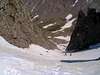
Spring snow season opens up a couple snow couloirs accessible from the Willow Creek drainage.
Starting at the popular Willow Creek TH hike up the excellent trail past Willow Lake and the waterfall. Continue up the basin to approximately 12,300'. Identify the summits of Kit Carson and Columbia Point and the deeply inset couloir between.
Route Description
The Outward Bound Couloir route gains the ridge at the 13,620 foot col between the two mountains. Ascend the steepening couloir (take the left fork near the top) to the saddle. Gain the col and descend just below it on the south side. Look for a cairn or two marking the start of the traverse to Columbia. It is not particularly obvious unless you are searching for it. Note that far below the saddle is another cairned route. I suspect this leads up another gully and intersects with the traverse but that is little more than a guess.
Anyway, find the start of the traverse and begin climbing steeply under the impossible looking SW face.
The whole traverse is cairned but most are small and the route is somewhat convoluted. In dry weather the route is moderately exposed scrambling. Keep your eyes open and your wits about you.
The traverse ends just below and slightly to the SE of the summit.
Roach's guidebook makes the traverse section seem easier and only rates it a 2 but I would rate it class 3. The traverse might be pretty sketchy with snow and ice. If you have first hand snow experience please post your knowledge.
 |  |
Essential Gear
Standard mountaineering kit plus crampons and ice axe.