Contribute
Loading...
Children  Loading...
Geography
Parents  Loading... Routes Routes
|
The Prow
|
|
|
Page Type: Route
Location:
Colorado, United States, North America
Lat/Lon:
37.97970°N / 105.6019°W
Route Type:
Technical Rock Climb
Time Required:
A long day
Difficulty:
Grade III Class 5.8
| Route Quality: | | |  | Loading...
|
Page By:
xyati
Created/Edited: Aug 2, 2005 / Aug 2, 2005
Object ID: 166090
Hits: 7429
Loading...
Page Score: 72.08%
- 2 Votes
Loading...
Vote: Log in to vote
|
Approach
From the town of Moffat in the San Luis Valley...Drive 11.8 miles to the entrance of Baca Grande Chalets Grants. This is Camino Baca Grande Road. (turn right). Follow this road 3.6 miles to the trail head. You will cross Crestone creek at .8 miles and Willow Creek at 2.2 miles. The next creek you get to is Spanish Creek. This is where to begin. Follow the trail just past the Monastery Sign. There is a Buddhist Monastery here so please pass by quietly and respectfully. The trail follows the creek for the most part.
Hike up the beautiful, lush valley along the Spanish Creek. BRING BUG SPRAY! The mosquitoes WILL KILL YOU. We were attacked by hundreds of thousands of them.. this is no joke. With all the scary diseases out there.. don't mess with this one. The trail is dense and relatively easy to follow. If you do get off trail, just keep heading up the valley along the river and you will find the trail again. Things get a little obscure again at a large burn area. There is a large deadfall area here and the trail is marked well with cairns. It can be tricky to stay on route in the dark like we did so just keep your head up when looking for the next cairn. We camped just below tree line. From tree line its a simple line to the base of the Prow. You know what it looks like, just scramble up to the base of it to begin your climb.
Route Description
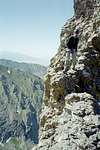
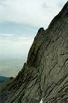
Scramlbe 3rd class to the base of the fin. This route is very commiting and there are very little options for retreat. Once you're on, you're on.
Pitch 1 of the route is about a 60 foot 5.6 ridge that can be simul-climbed. It ends at an obvious overhanging headwall. This is where the second pitch, and the crux, starts. Pitch 2 climbs up this head wall, one or two 5.8 moves. Some guide books say to go right once above this headwall to avoid a bulge. As long as you don't go too far right for too long this might be ok. I think it would be best to just stick to the ridge. I went too far right and ended up on some of the scariest 5.11 unprotected face climbing I've ever seen. 60' run-out on sloping holds with 1000 feet of air below you = not too fun. (unless you are sick in the head) The rest of the pitches follow the ridge to the summit. mostly 5.6 to 5.7 moves all the way. The rock is solid and the exposure is real. Towards the top the climbing eases off to a 4th class knife ridge and meets with the trail to Challenger Point. From here, belay from next to the trail and take the headwall directly in front of you to the summit. (easy 5.6) This is a GREAT, fun climb.
Essential Gear
BRING BUG SPRAY BRING BUG SPRAY BRING BUG SPRAY!
There are millions of these little demons on the approach and you WILL REGRET not having BUG SPRAY.
ok that's out of the way.
Bring a small rack of cams. You won't need anything over a nubmer 4. mini cams are real useful here. We brought one 200 foot rope, 10 cams, 10 quick draws and a small rack of stoppers. A few slings completed our collection. Light and fast is your best bet on this climb. Get off before the lightning gets you. Also, the lighter you are, the easier the 5.8 overhang crux is.
Be prepared for long runouts. The rock is solid, but there is not an abundance of available placements. With such exposure and long runouts, even though it's a 5.8 it's a serious climb.
Miscellaneous Info
If you have information about this route that doesn't pertain to any of the other sections, please add it here.
Additions and Corrections[ Post an Addition or Correction ] | clevelac | Route Comment | | 
Hasn't voted | While it is suggested above that this climb can be done in "a long day," that is an understatement. It is "possible" to do this route car-to-car in a day, but this would not be realistic for most parties. A successful ascent of the Prow will be much more likely from a high camp. | | Posted Sep 27, 2005 8:19 am |
 | | xyati | Route Comment | | 
Hasn't voted | Thanks for the post.. but I must disagree. By a long day I mean over 14 hours. It is entirely possible to acheive this route in that time frame. 4 hours to above the burn. About 6 hours on the route itself (if you take your time) another hour to descend to the burn area from the summit. Then an easy 2 or 21/2 hours down to the car. If you're in shape (and you should be for this climb) then it is not only possible, but very achieveable. Just bring a headlamp. Also.. I would Recommend doing the approach and the descent in the dark to avoid the mosquitos.
For the record, we made a high camp when we did this climb. Becasue of the extra time it took to set up camp, then break down when done, it seemed like more work than it was worth. Furthermore, neither one of us got much sleep anyway. From my experience, I can say that it is best to forego a campsite and give it a long push when possible. You can sleep better before hand, you don't need to carry all the extra weight (making your ascent easier), and when you are off the actual route, you can just blaze back to the car instead of wasting time and energy to stop and break down a camp. | | Posted Feb 6, 2006 11:58 am |
| clevelac | Apples and oranges | | 
Hasn't voted | Possible in a day? Absolutely. More likely to succeed in a day? I would say no.
Anyway, I think you do others a disservice recommending a strategy that you haven't done yourself. Adding up your times from A to B is easy to do after the fact, but doing it all in one push just ain't the same.
In my opinion, a strong party could definitely knock this out in a day (with no weather issues) no problem, but I still think the chances of success for most are greater with a high camp. Besides, this route should be savored, and the valley is a sweet place to spend some time. | | Posted Sep 24, 2006 1:23 am |
 | | philwortmann | Re: Apples and oranges | | Voted 10/10 | I climbed this route with xyati and have to agree with him. Hiking in with camping gear weight means you need more food, more water, and more time. It is much easier to man up and flash it. It is also a cleaner style, which saves this "sweet place" for future generations. Mark and I have since employed a lighter and faster style to climb much harder routes than this on other peaks, and know that this one would go easier with this more modern style. Your slow and heavy approach to alpinism belongs to the last century, not this one. I suggest you spend less time packing and more time training. | | Posted Dec 8, 2006 6:45 pm |
 | | xyati | Re: Apples and oranges | | 
Hasn't voted | Mr. Apples and Oranges,
The only disservice I see is the reaction you decided to publically post for somehow being insulted by someone else's progress. I suggested doing this in a day becasue it IS entirely possible and success is MUCH MORE probable. It sounds as though you should take your own advice, sir, and stick to the strategies you are familiar with. For the record, other routes my climbing partner and I have accomplished in a day with tremendous success: Casual Route, Longs Peak. Ellignwood Arette, Crestone Needle. Total Abandon, Pikes Peak. Alexandars Chimney, Longs Peak. So I hope that those successes qualifiy me enough to recommend a strategy for others to enjoy. | | Posted Dec 12, 2006 11:32 pm |
Images
|
|