Southeast Rib
Stats: 7.3 miles, 2910’ via the Southeast Rib
Partners: S, G
A couple of friends and I wanted to do a peak that was a little more than a hike yet wasn’t too technical, and had easy access. G had done Rainier and S an Ironman, but neither had really been off trail and on their own. Paiute, with a road going to within a few miles of the base and 2 miles of great trail up to Blue Lake, seemed like a perfect place to play close to home.
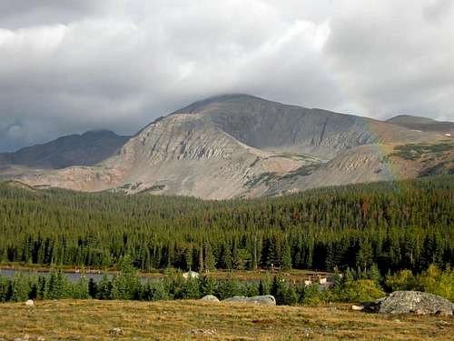
The forecast called for improving weather thoughout the morning, so we set off from north Boulder just after 0700. There were clear skies over Boulder and white puffies skittering across the Divide. Large raindrops splattered in my car window as we paid the $8 extortion fee to get into Brainard Lake. The rain picked up as we approached the lake, so we pulled into the overlook at the eastern end of the lake to wait for a few minutes and take in the view. We could see both ends of a beautiful rainbow stretching from Audubon to Niwot against a shifting dark grey backdrop.
![Audubon and Paiute]() Right side of rainbow spanning the Brainard basin. Paiute, our destination, is the peak with its head in the dark clouds in the background.
Right side of rainbow spanning the Brainard basin. Paiute, our destination, is the peak with its head in the dark clouds in the background.
When the rain slowed down, we drove up to the trailhead, loaded up packs, and headed up trail at 0817. The rain picked up again as we neared Mitchell Lake, so we took shelter in the trees just before the creek crossing. After adding rain gear, we continued on. We only passed one person as we ambled up the trail to Blue Lake. After snacking at Blue, we headed counterclockwise around the lake on a thin foot track through the grasses and followed it up over a couple of small streams and onto the bed of rocks above the northwest corner of Blue Lake at around 11,400’. We picked up the hiker’s trail on the land island to hiker’s left and followed it up and over a couple of small granitic caps to where it ends at a stream crossing. I picked out the cairns on the other side, the first of which sit on the flat face of a large rock, and we headed up into the boulders. Following the cairns made for easy and quick travel up to the unnamed lake at 11,833’.
![SE rib path]()
![Blue Lake]() Ambling along the trail above the oh-so-blue Blue Lake.
Ambling along the trail above the oh-so-blue Blue Lake.
After a second snack break, we donned helmets and headed up onto the rib.
![North Face]() G pointing at Toll's north face - not this time!
G pointing at Toll's north face - not this time!
We scrambled up through the alternating bands of rocks and tundra, moving left as necessary to keep things at easy third class. About halfway up, we had small rest break as G tried to snap some pictures of an ermine.
![Scrambling on SE Rib]() S and G scrambling about halfway up the southeast rib.
S and G scrambling about halfway up the southeast rib.![Summit Ridge]() S clowning around after we topped out on the rib and started up the summit ridge.
S clowning around after we topped out on the rib and started up the summit ridge.
When we hit the top of the ridge, we scrambled up to climber’s right and topped out at around 1300. The “summit” is a single larger block on the fairly flat rocky tundra that makes up most of the summit. G and I scrambled across the narrow neck to the north summit while S rested in the lee of the summit block. G and I were buffeted by wind gusts on the crossing. Dark, ponderous rain clouds were sweeping across the peaks to the north and east, and S said he’d seen lightning, so we hustled off the summit and headed down ridge to eat lunch.
![South Summit]() Looking back towards the S summit from the N summit. See S hunched down just below the summit block?
Looking back towards the S summit from the N summit. See S hunched down just below the summit block?![View from North Summit]() Ominous rain clouds flitting across the Divide to the north.
Ominous rain clouds flitting across the Divide to the north.
I’ve read some trip reports that talk about getting cliffed out on the descent. The easiest way to avoid that is to descend the summit ridge to the south until you come to the saddle at the top of the couloir immediately west of the southeast rib, just a few minutes down ridge. At this point, you can either descend the couloir or head back down the rock bands. To speed up our descent, we opted to scree ski the couloir and were back at the base of the rib in short order. We enjoyed the awesome afternoon weather and fall colors as we ambled back to the trailhead.
![Colors above Mitchell Lake]() Beautiful fall colors coming in at the bogs above Mitchell Lake. This looks like a place a moose would love.
Beautiful fall colors coming in at the bogs above Mitchell Lake. This looks like a place a moose would love.
Comments
No comments posted yet.