
-
 42508 Hits
-
 89.39% Score
-
 29 Votes
|
|
Mountain/Rock |
|---|---|
|
|
40.09830°N / 105.6322°W |
|
|
13088 ft / 3989 m |
|
|
Paiute Peak Overview
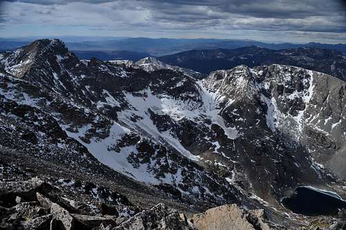
Paiute Peak and Upper Coney Lake under grey October skies.
Paiute Peak is located in the fabulous Indian Peaks Wilderness. Although this represents one of the most heavily utilized wildernesses in the nation (being only about an hour's drive from Denver) there are plenty of chances for solitude in the area.
The Indian Peak Wilderness rests just south of Rocky Mountain National Park; it is basically an extension of its neighboring national park (although the Forest Service's stewardship is a bit different from the Park Service's in practice). As Gerry Roach notes in his popular book "It is smaller than Rocky Mountain National Park, but no less spectacular."
Paiute Peak sits high and mighty on the Continental Divide at the head of the Blue Lake drainage. It is a rugged mountain situated just to the west of the higher and more popular Mount Audubon. To its south rises the spectacular twelver Mount Toll. To its north is "Algonquin Peak" and Sawtooth Mountain. Amidst such spectacular company the views from Paiute Peak are impressive. From the summit is a commanding view of Longs Peak
Paiute Peak offers a more demanding climb then nearby Mount Audubon but it is easier than the other two nearby "scrambling" thirteeners, Apache Peak and Navajo Peak. Its easiest route follows a rocky couloir which rises to the northwest from the unnamed lakes above Blue Lake. An even more enjoyable route follows Paiute's east ridge from the summit of Mount Audubon. This ridgewalk is not much more difficult than the standard route and it is on more solid rock. The actual summit area of Paiute Peak is cleft into an eastern and western summit (separated by only 30 feet or so). The eastern summit is easy to get to and has the summit register; the western summit is just as high and getting to it involves the most difficult move on the described routes.
Paiute Peak is a complex mountain and presents a very different countenance when viewed from different aspects. The relaxed southeast face stands in sharp contrast to the scary north face (best observed from "Algonquin Peak") or the sheer western slopes. Enjoy this mountain named after Colorado's famed mountain Indians.
 |
 |
 |
 |
 |
Getting There
The Mitchell Lake Trailhead is at 10,500 ft.. and provides access to the Mount Audubon Trail and the Blue Lakes Trail. For the northern approach to this trail go south 10.2 miles on Colorado 72 from its junction Colorado 7. For the southern approach, go north 12 miles on Colorado 72 from Nederland to the Brainard lake road, which is just north of the tiny town of Ward. Turn west on the Brainard Lake Road and go 4.9 miles to Brainard Lake. About a mile into this stretch you will have to pay a small fee, around $5 for access to this area.
 |
 |
Mountain Conditions and Maps
The following map was produced with my licensed copy of National Geographics Topo software.
 |
Red Tape
Here is a summary of the Indian Peak Wilderness Rules and Regulations.
- Mechanized vehicles are not permitted, including bicycles and hang-gliders.
- A permit is required for camping in the wilderness area between June 1 and Sept. 15. Permits are issued for 19 travel zones within the Indian Peak boundaries. Permits are $5.00 at the following offices. For information or to apply for a use permit, contact the U.S. Forest Service, Boulder Ranger District, 2140 Yarmouth Ave., 303-541-2500, or the Sulphur Ranger District, 9 Ten Mile Drive, P.O. Box 10, Granby, CO 80446, 1-970-887-4100. For recorded information, call the Indian Peaks Wilderness Information Line at 303-541-2519.
- Only a certain number of groups are allowed in each travel zone for overnight camping. Camping is limited to two weeks in any four-week period; the two weeks can be in any travel zone.
- Organized groups (maximum size of 12) must have a permit for camping or hiking at all times.
- Campsites must be at least 100 yards from lakes and streams.
- Fires are prohibited east of the Continental Divide. Fires are allowed in certain areas west of the divide.
- Dogs must be leashed.
![]()
![]()
![]()
![]()
When To Climb
The prime climbing season runs from June through September. The Brainard Lake area is closed in October-May. Be wary as this area can get a phenomenal amount of snow in the winter. Although it is possible for a winter ascent by hiking up the closed roads it would likely be a two-day excursion.
![]()
![]()
![]()
External Links
- Book Review: Indian Peak Descents
Review by Couloir Magazine, a decent backcountry ski mag. - Paiute Peak ski
Conditions from some guy's 1994 descent of Paiute. Obviously not meant as an updated conditions page, but gives some good descriptions of the details of the descent. - The Audubon to Little Pawnee Ridge Adventure
- Book Review: Indian Peak Descents


