
-
 6021 Hits
-
 92.04% Score
-
 37 Votes
|
|
Route |
|---|---|
|
|
46.41668°N / 10.61695°E |
|
|
Mountaineering |
|
|
Spring, Summer |
|
|
Most of a day |
|
|
Alpine F |
|
|
Overview
Palon de la Mare SW Flank Normal Route, an easy route to one of the highest peaks of Ortles-Cevedale Group.
Palon de la Mare is a mountain belonging to the "Ortles-Cevedale group", Southern Rhaetian Alps, and located between Cevedale and Vioz. The South-West Flank route is the normal way to climb Palon de la Mare, a large and massive peak culminating with a wide ice-cap, covered and surrounded by six glaciers, which in the Eastern Alps are taking the name of Vedrette: Vedretta dei Forni to the South, Vedretta del Palon de la Mare to the SW, Vedretta de la Mare to the NE, Vedretta Rossa to the E, Vedretta del Col de la Mare I to the NNW and Vedretta del Col de la Mare II to the NW.
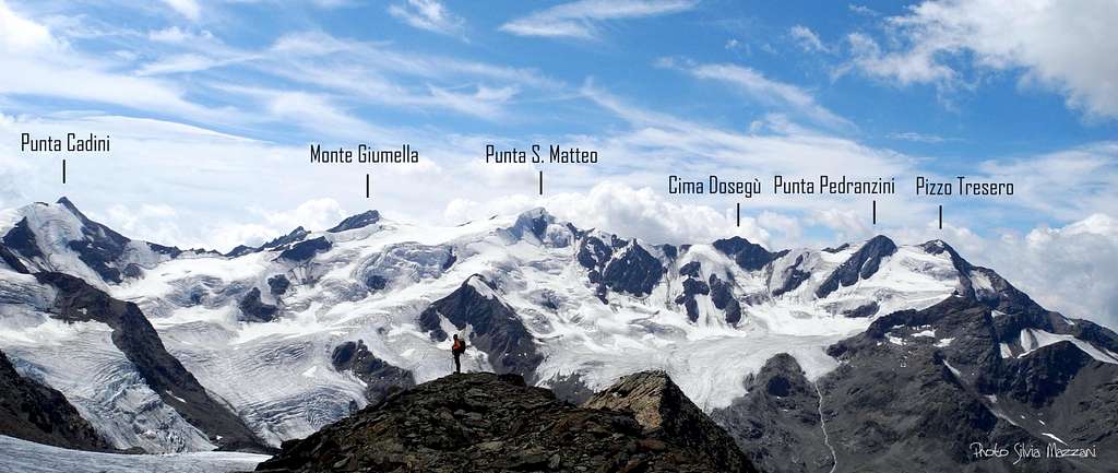
Thirteen Summits SW sector seen from Palon de La Mare SW route
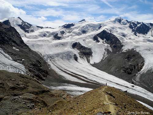
The Normal route is an itinerary without particular difficulty, frequently climbed mainly in late spring or early summer. The route is usually climbed also by the sky-mountaineers, as a classic "course". The only problem is to be careful on the glacier, due to the presence of some crevasses. The SW Flank route is entirely running in upper Valtellina, Sondrio province (Western side), while the peak is lying on the boundary ridge between Trento province on North-East side and Sondrio province on South-West. The views towards the main peaks of the group are spectacular and wide.
Getting There
Road access
The starting point is the village of Santa Caterina Valfurva m. 1734, situated 12,5 km. to Bormio, an important destination which can be approached from Milan following Valtellina and from Alto-Adige through Stelvio pass. From Santa Caterina a steep road leads to the Ghiacciaio dei Forni parking (8 km. from S. Caterina Valfurva).
- From Autobrennero exit Bolzano and follow the road to Merano, then enter Venosta Valley and follow it to the fork in Spondigna. Turn to left, following the road to Passo delle Stelvio (2758 meters, open only in the summer period). From here descent to Bormio (3 hours and half from Bozen, Stelvio pass requires 44 bends to go up and 15 to go down).
- From Milano follow the statal route "Valsassina" number 36 to Lecco and then to Colico, here take the "Valtellina" road to Morbegno, Sondrio, Tirano and then to Bormio.

Walking approach
From Ghiacciaio dei Forni Hut (parking) m. 2178 a good path starts, heading towards East and crossing Cedec stream. After some steep hairpins the path is reaching the comfortable Branca Hut m. 2493 (1 hour from the parking), overlooking the mighty Vedretta dei Forni and the small Rosole Lake.
SW Flank Normal Route report
SW Flank Normal Route report
Summit altitude: m. 3703 Difficulty: Alpine F Climbing length: 1200 m. Exposure: SW First ascent: Julius Payer, Johann Pinggera and Antonio Chiesa (September 10th 1867) coming down Starting point: Santa Caterina Valfurva (SO) m. 1734 Hut: Branca Hut m. 2493
An easy and interesting route leading to a superb and panoramic summit. The only problems are represented late in the summer by the crevasses along the Palon de la Mare glacier and in case of bad weather by the mist along the upper section of the route.
")

Behind the Refege Branca take a level trail towards SSE, crossing a bridge and heading towards the right lateral (orographical) moraine of Forni Glacier; after 10 min. the trail is getting to the moraine and starting to rise steeply along its sharp ridge. At about 2800 m. the trail heads toward left (NE), leading to a scree basin. Climb on the left side a rocky ridge following a well cairned trail and leading to Palon de la Mare glacier’s starting point at about 3000 m. From here there are two chances: A - Follow the left edge of the glacier (right orographical), becoming more and more steep and leading to the left edge of the “plateau”: This route is usually followed by the sky-mountaineers in spring, where the glacier is snow-covered.
B - In summer season the best option is to carry on along the easy and well cairned ridge - which was garrisoned by the Austrians during the I World War (even at present several military ruins are visible) – leading to the left edge of the plateau. This route is a good choice late in the summer when the glacier is full of crevasses.

The two different routes join in the left edge of the plateau; cross the glacier towards North (several deep crevasses), then turn to right (SE) and follow the glacier reaching the SW ridge. An easy climb along the ridge leads towards the last summit snow ridge and to the summit.
Descent: following the same route
Essential Gear
Rope, ice-axe, crampons, high mountain clothes.
Red Tape


Palon de la Mare, as all Ortles-Cevedale Group, is situated inside Parco Nazionale dello Stelvio, one of the hystorical national parks in Italy, belonging to the provinces of Trento, Bolzano and Sondrio. Free camping is not allowed and fires are strictly forbidden. The whole fauna and flora are protected. Don’t disturb fauna and other mountaineering and hikers’ peacefulness with every kind of noise.
Hut

- Rifugio Branca 2493 m - Club Alpino Italiano C.A.I Sez. di Milano
In the middle of Parco Nazionale dello Stelvio at 2493 mt is situated the Branca Hut guarded by Alberti/Confortola family, rising in front of the huge Forni Glacier and dominated by S.Matteo (3678 m.), Tresero, (3594 m.), Vioz (3645 m.), Palòn de la Mare (3708 m.) and Cevedale (3769 m.).
...and don't forget to eat the spectacular hut's main course: i Pizzoccheri della Valtellina!!!!
When to climb
Mountaineering: usually the best period goes from June to the middle of September.

Ski-Mountaineering: from March to May
Guidebooks and Maps


- Guidebooks
“Ortles Cevedale – Parco nazionale dello Stelvio” by Gino Buscaini (Club Alpino Accademico Italiano) – Collana Guide dei Monti d'Italia CAI-TCI (Club Alpino Italiano-Touring Club Italiano)
- Maps
“Ortles-Cevedale”, foglio 72 - Kompass 1:50.000
Meteo
Meteo Lombardia
Meteo Montagna Valtellina
Meteo Trentino