
-
 14278 Hits
-
 81.84% Score
-
 14 Votes
|
|
Mountain/Rock |
|---|---|
|
|
44.72920°N / 121.8044°W |
|
|
7078 ft / 2157 m |
|
|
Overview
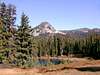
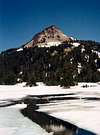
 Park Ridge is, as its name implies, a long ridge that one must cross when hiking into Mt. Jefferson from the north. There are about 8 peaks along it but one summit that is not far off the Pacific Crest Trail. Awesome views of many peaks in the Mt. Jefferson Wilderness are afforded. There is a vague trail to the summit but the forest is very thin and it's easy to find your way out to it.
 |  |  |  |
Getting There
It's not that easy to get there. You'll need a vehicle with high clearance and, depending on conditions, 4WD as the "road" to the trailhead is not maintained and very rocky and rutted.
From Portland, take exit 12 off Interstate 205 and head east towards Estacada on Highway 224. Continue past Estacada another 26 miles to the Ripplebrook Ranger Station. Right after Ripplebrook, the road will fork and you want to take it to the right which is now Road 46. Take Road 46 about 27.5 miles from the Ripplebrook Ranger Station further south to Road 4220. This road is just before the huge power lines so if you pass under them or go past an "Entering Mt. Hood Wilderness" sign, you have just passed it.
Turn left onto Road 4220. It does not appear to be signed anymore but know that if you go under the power lines about 50 yards from Road 46, you rare on the right road. It's gravel for a while then turns to dirt and rocks. Drive 6.3 miles to a road on the right. There is a small wooden sign there pointing further down Road 4220 pointing to Breitenbush Campground. Go down this road about 100 yards (this is also where the PCT crosses Road 4220) to a circular parking area with toilets. The trailhead is at this parking lot. If you get to Breitenbush Lake Campground, you've gone too far.
(Note-I know if you are looking at this hike in Sullivan's 100 Hikes in Northwest Oregon that the directions are different. His way takes you a lot longer and, even though the terrible road part of his directions may be a couple miles less than the terrible road part of my directions, I'm not sure it's worth it to use his directions.)
Red Tape
A Northwest Forest Pass is required to park in the lot. You also need a Wilderness Permit which are free and self-service issued at the sign about 20 yards into the trail.When To Climb
Mid-July to mid-October, before or after and you take your chances with snow closing the roads. Road 4220 is gated and locked after the first snowfall.Camping
Camping is allowed on the trail and in the area. Breitenbush Lake Campground is right next to the trailhead. There are also various campsites along Road 4220. About 3/4 of the way to Park Ridge is a very nice campsite next to a small lake. Also, about 2 miles past Park Ridge on the PCT is Jefferson Park, a very popular camping area for backpackers/climbers at the base of Mt. Jefferson. Camping is free.Mountain Conditions
Estacada Ranger District(503) 630-6861
mandrake - Sep 26, 2006 8:30 pm - Hasn't voted
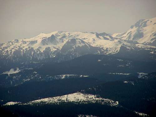
Park Butte from Jefferson ParkNice side trip from camp in Jefferson Park. Head up the PCT to the basin just east of Jeff Park Butte and scramble westward up to the obvious saddle in the ridgeline above. From that point there's an easy scramble south to the summit. Terrific views of the lake basin below.