Approach
The beginning of Adventure Ridge starts at the summit of Bear Point. There is a couple of ways to get to Bear point, by way of trail or a quick scramble from Crown Lake. I prefer the Crown Lake scramble. From Salem take Hwy 22 east to Detroit Lake. At the (only) gas station in Detroit, Take a left on Hwy 46 north. Drive for about 12 miles; take a right on road #4685. Or from Estacada take Hwy 46 south towards Detroit Lake and take a left on road #4685. Road 4685 follows the South Fork Breitenbush River for about 5 miles before switching back up the north side of Breitenbush Gorge. Look for a large trailhead parking lot on you right. This is one of the main trailhead into the Jefferson Wilderness. Take trail #3375 for about 2miles, and then hop onto trail #3342 for a 2-mile, 1700’ summit of Bear point. For the Crown lake scramble to bear point you’ll continue on road #4685 around the switchback for about 7.5 miles from Hwy 46. Take road #330 to the end of the road. This is the trailhead to Crown Lake. Take a short trail to Crown Lake. A GPS, map, and a compass will help navigate from Crown Lake to the summit of Bear point. (I’ve almost worn a trail)
Route Description
![]()
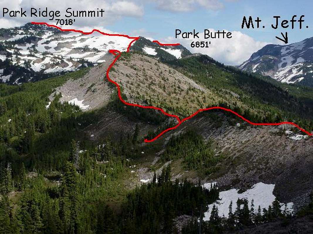
Bear point is a good place to take a breather. You just climbed 1700’ in 2 miles or bushwhacked through dense vegetation 1000’ in 1 mile. From here Adventure Ridge looks like a “walk in the park”. That’s what I thought last time I was on top of Bear Point and that’s why I came back. As you look at Park Ridge, Adventure Ridge snakes up and down and side to side in a southeast direction. From here to Park Ridge summit is only about 3 miles but seems a bit more. There is a lot of variety in the terrain. You go from scree hills, to large boulder climbs. From red lava beds to almost beach like sand beds. The views are incredible. At the .6 mark you’ll come to a large solid rock outcropping standing taller than the ridge itself. The eastern side looks to be solid & stable enough for some good rock climbing. At the 1.5-mile mark you come to a good place to do a side trip up to the summit of Dinah-Mo Peak. This peak didn’t look like much till we saw the side view. We didn’t have the time to summit Dinah-Mo Peak but we did put it on our “To-do” list. There’s not much shade on this ridge as the vegetation is dwarfed from the harsh weather elements. At the 2-mile mark you’ll begin your final 900’ ascent to the Park Ridge Summit. From here the north side of Adventure Ridge is bare, the south side is treed. When you get within a quarter of a mile from the true summit you’ll see to your right the sharp craggy ridge leading south out to Park Butte. From there you’ll enjoy an incredible “in your face” view of Mount Jefferson. Look down for a wonderful view of Jefferson Park, a popular destination for backpackers & climbers
Essential Gear
Comfortable boots with good traction and good ankle support. You always seem to be walking across a slope while on a ridge top. Take lots of water, as there is little shade on adventure ridge. A backpack is a must, as parts of this ridge are large boulder climbs and you'll need both hands free. Until late summer sunglasses are necessary because of the long lasting snow patches.
Miscellaneous Info
I couldn't get my cell phone to work on top of Park Ridge

 12219 Hits
 71.06% Score
 1 Votes