Overview
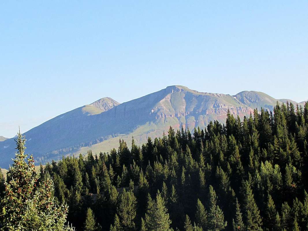
![]()
East face of Peak 13042 ft, note the band of cliffs above Putnam Basin.
Name: This peak has no official name.
Rank: Peak 13042 ft is Colorado’s 612th highest ranked peak.
Prominence: 942 ft.
Peak 13042 ft rises to the west of the town of Silverton in the San Juan Mountains of southwestern Colorado. The eastern slopes of Peak 13042 ft are steep/wall-like and drop down into Putnam Basin. The western slopes, above 12000 ft, are in contrast quite gentle and are covered by beautiful grass all the way up to the summit. A band of cliffs tens of miles long traverses the slopes of many of the mountains in the area at an elevation of 11800-12000 ft creating a serious obstacle to the hiker. Occasional breaks in these cliffs, however, do provide walk-up access to the summits of the peaks. One such break happens to the southwest of Peak 13042 ft above Colorado Trail. You could start at Little Molas Lake Trailhead off of Route 550 and follow Colorado trail until you see the break. You can then leave the trail and find your own way to the summit of Peak 13042 ft.
![]()
Southeast face, L to R: Peak 13042 ft, Peak 12764 ft & Point 12613 ft.
Getting There
Directions to Little Molas Lake Trailhead (not to be confused with Molas Lake Trailhead):
From Silverton, drive 7 miles south on Route 550 to the well signed Little Molas Lake Campground/Trailhead on the west side of the road. Turn west and drive the well graded dirt road about a mile past the camp site to the end of the road at the trailhead.
Route, from Little Molas Lake
All distances are per my GPS
Net elevation gain is 2150 ft. Due to the many ups and downs on the trail, my GPS recorded a total ascent of
3075 ft, 12.4 miles roundtrip.
| Place | Elevation | Distance |
| Little Molas Lake Trailhead | 10900 ft | zero miles |
| Broad Saddle | 11540 ft | 3.20 miles |
| Leave Trail | 11500 ft | 1.75 miles |
| Saddle | 12100 ft | 0.65 miles |
| Summit | 13042 ft | 0.60 miles |
| Total | - | 6.20 miles |
At the trailhead, Peak 13042 ft will not be visible. Get on Colorado Trail and head west. The trail zigzags up through a sparse forest and soon gets on grassy slopes that are mostly without trees. You will soon have a glimpse of Little Molas Lake with the peaks of the Grenadier Range in the back.
![Little Molas Lake & The Grenadier Range]() Little Molas Lake & The Grenadier Range Little Molas Lake & The Grenadier Range |
You will then find the trail on the crest of a very broad and gently sloped ridgeline going uphill.
![Rolling Mountain far right]() Rolling Mountain & Peak 12569 ft Rolling Mountain & Peak 12569 ft |
![North Twilight Peak]() North Twilight Peak North Twilight Peak |
![Engineer Mountain]() Engineer Mountain Engineer Mountain |
After 3.2 miles, you will reach a wide saddle between Peak 12764 ft to the west and Peak 12849 ft to the east. Bear Mountain comes to view to the north.
![Bear Mountain]() Bear Mountain Bear Mountain |
Continue on the trail on the south side of Peak 12764 ft.
![The Grenadier Range]() The Grenadier Range The Grenadier Range |
![Potato Hill]() Potato Hill Potato Hill |
![On Colorado Trail]() On Colorado Trail On Colorado Trail |
![Peak 12764 ft]() Peak 12764 ft Peak 12764 ft |
![Engineer Mountain]() Engineer Mountain Engineer Mountain |
![Peak 12569 ft & the tip of Engineer Mountain 12968 ft]() Peak 12569 ft Peak 12569 ft |
![Potato Hill & North Twilight Peak]() Twilight Peaks & Potato Hill Twilight Peaks & Potato Hill |
![Snowdon & South Snowdon Peaks]() Snowdon Peaks Snowdon Peaks |
![Peak 12569 ft & Point 12766 ft]() Peak 12569 ft & Point 12766 ft Peak 12569 ft & Point 12766 ft |
The trail does a number of small ups and downs as it heads northwest. You will note a continuous band of cliffs above you on the southern slopes of Peak 12764 ft. At some point at around 11500 ft, the trail begins to go downhill more steeply making a bend to head southwest on the slopes of Point 12601 ft. You will find a break in the cliffs above you.
![Break in the cliffs]() Break in the cliffs Break in the cliffs |
Leave trail and head up the grassy slopes through the opening in the cliffs. A faint trail actually takes you there but where it branches off of Colorado trail is hard to find.
![Cliffs below Peak 12601 ft]() Cliffs below Peak 12601 ft Cliffs below Peak 12601 ft |
|
|
|
|
![Hiking up grassy slopes]() Twilight Peaks & Potato Hill Twilight Peaks & Potato Hill |
Once you go through the opening in the cliffs, you will find yourself at a 12100 ft saddle where you seem to be on a high grassy plateau surrounded by cliffs below.
![Golden Horn, Vermilion/Fuller and Beattie Peaks]() The Vermilion Group The Vermilion Group |
![Twin Sisters]() Twin Sisters Twin Sisters |
Hike northeast up the beautiful grassy slopes of Peak 13042 ft.
Just below the summit.
![The summit of Peak 13042 ft]() The summit of Peak 13042 ft The summit of Peak 13042 ft |
Views from the summit of Peak 13042 ft.
![Vermilion Peak Group]() The Vermilion Group The Vermilion Group |
![US Grant Peak far left]() US Grant, Lookout Peak US Grant, Lookout Peak |
![Too many 13ers to count]() North toward Red Mountain Pass North toward Red Mountain Pass |
![Bear Mountain]() Bear Mountain Bear Mountain |
![Twin Sisters (far left) and many others]() Twin Sisters, Rolling Mtn Twin Sisters, Rolling Mtn |
![Engineer, Grayrock, Jura Knob and many others]() Engineer Mtn Engineer Mtn |
![Ridgeline to Bear Mountain]() Ridge to Bear Mtn Ridge to Bear Mtn |
![Potato Hill & the Twilight Peaks]() Potato Hill & Twilight Peaks Potato Hill & Twilight Peaks |
![The Needle Mountains & Snowdon Peaks]() Snowdon Peaks & The Needles Snowdon Peaks & The Needles |
![Sultan Mountain and The Grand Turk]() Sultan Mtn & The Grand Turk Sultan Mtn & The Grand Turk |
![The Grenadier Range]() The Grenadier Range The Grenadier Range |
Red Tape
No permits or fees.


 Little Molas Lake & The Grenadier Range
 Rolling Mountain & Peak 12569 ft
 North Twilight Peak
 Engineer Mountain
 Bear Mountain
 The Grenadier Range
 Potato Hill
 On Colorado Trail
 Peak 12764 ft
 Engineer Mountain
 Peak 12569 ft
 Twilight Peaks & Potato Hill
 Snowdon Peaks
 Peak 12569 ft & Point 12766 ft
 Break in the cliffs
 Cliffs below Peak 12601 ft


 Twilight Peaks & Potato Hill
 The Vermilion Group
 Twin Sisters


 The summit of Peak 13042 ft
 The Vermilion Group
 US Grant, Lookout Peak
 North toward Red Mountain Pass
 Bear Mountain
 Twin Sisters, Rolling Mtn
 Engineer Mtn
 Ridge to Bear Mtn
 Potato Hill & Twilight Peaks
 Snowdon Peaks & The Needles
 Sultan Mtn & The Grand Turk
 The Grenadier Range