
|
|
Mountain/Rock |
|---|---|
|
|
39.02216°N / 108.61754°W |
|
|
Mesa |
|
|
Hiking |
|
|
Spring, Summer, Fall, Winter |
|
|
5750 ft / 1753 m |
|
|
Overview
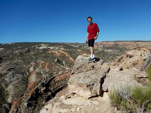
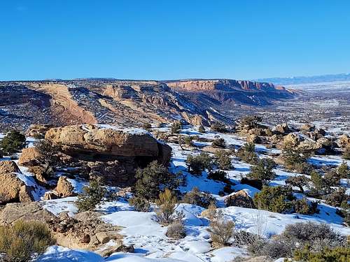
Peak 5750 is the closest ranked peak (a ranked peak is an official peak that has a least 300 feet of prominence/saddle rise) to my house, thus I have climbed it many times, usually before and after work. Even though the peak is right outside of Grand Junction, it's a fine destination and a spectacular viewpoint. The views are well worth the effort it takes to hike there. The peak also sits at the southern end of a mountain biking mecca known as the Lunch Loops. Hikers are also welcome too and while technically bikers are supposed to yeild to hikers, I always step off the trail and let them pass. If you are here on a weekend in spring or fall you might see quite a bit of bike traffic, but since I almost always go after work on weekdays, I seldom see them.
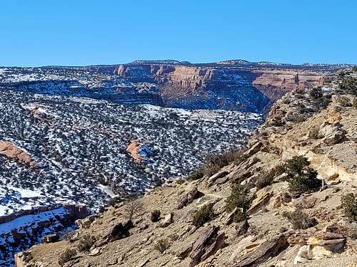
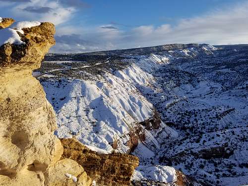
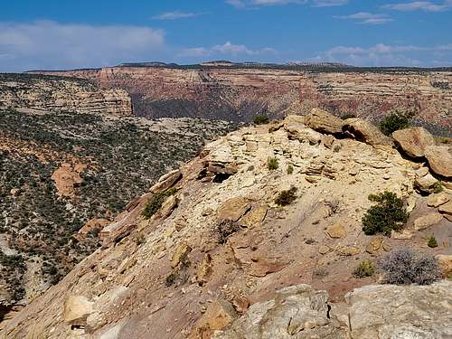
The peak provides a spectacular view to the south down into Echo Canyon. To the west is a nice view of Colorado National Monument. The the east is Grand Mesa and to the north Grand Junction. There are many, many trails here so you can go crazy with all the route variations you desire.
Note: Although this peak is just outside Colorado National Monument, for simplicity purposes, it seems best to attach it to that page.
Getting There
Tabeguache/Lunch Line Trailhead
This trailhead provides the shortest and easiest route to Peak 5750. Simply put, drive Little Park Road for about 3.8 miles from the intersection with Monument Road and park on the large parking lot on the east side of the road. Look across the road for either the sign for the Lunch Line Trail or the Tabeguache Trail.
Holey Bucket Trailhead
Simply put, drive Little Park Road for about 3.8 miles from the intersection with Monument Road and look for the gravel road heading east. This leads to the trailhead and sometimes has a few rough spots. Google maps does have the Holey Bucket Trailhead on it.
Lunch Loops Trailhead
Google maps has this one too. This large trailhead is about 1.6 miles up the Monument Road from Broadway. You can't miss it (or if you do, you're in the wrong sport!). This trailhead is equiped with restrooms.
Routes Overview
You can really go nuts here. I have climbed the peak from dozens of variations, making many loop hikes.
Lunch Line Trailhead Route
The shortest route is from the Lunch Line Trailhead. When I am pressed for time, this is the route I take. Follow the Lunch Line trail to Eagles Wing/Free Lunch Trail and take a left (0.5 miles). Head left along the trail for 0.2 miles and take another left. Follow the Eagles Wing Trail to the obvious summit, which is only a few feet off the trail. If you want a short loop hike you can descend the Eagle's Wing Trail to the Tabeguache Trail and follow it down to the trailhead. Make sure to scramble up Eagles Nest Rock along the way to the summit of Peak 5750. There are lots of possibilities.
Holey Bucket and Lunch Loop Trailheads Routes
Get a map (or print one off) and go nuts. There are many route variations and trails here. I have done dozens of variations. Remember that this area is very popular with mountain bikers, especially on weekends in spring and fall. As mentioned above, while technically bikers are supposed to yeild to hikers, I always step off the trail and let them pass. On weekdays or in winter and summer you don't see as many. I usually climb the peak in the evening.
Click for larger size map:

Red Tape
This is a day use only area. Picking up after dogs is mandatory.
When to Climb
In theory, Spring and Fall have the most ideal weather, but you can and I have climbed the mountain every month of the year. This is the desert, so sunshine is plentiful and precipitation light. Snowfall is also light, especially by Colorado standards. In winter, the route from Lunch Line Trailhead is best because it's almost all rock and gravel rather than mud. Microspikes can be useful at times, but usually the snow does melt off pretty fast here in the desert.
Mornings and evenings in summer are pleasant too, but afternoons can be hot. The peak is a nice place to go for the sunset.
Camping
This is a day use area so no camping is allowed. The closest camping is probably the KOA in Grand Junction, but there are a lot of places in Grand Junction to stay without camping as well.
Mountain Conditions
Click Here for the Weather Forecast for Peak 5750.
Below is the National Weather Service Climate Summary for nearby Grand Junction 1928-2022. Temperatures might be about 3-5 degrees cooler on Peak 5750.
| MONTH | AVE HIGH | AVE LOW | REC HIGH | REC LOW | AVE PREC (in) |
AVE SNOW (in) |
| JAN | 37 | 16 | 60 | -23 | 0.61 | 5.8 |
| FEB | 45 | 23 | 69 | -21 | 0.56 | 3.6 |
| MAR | 56 | 31 | 81 | 5 | 0.82 | 2.9 |
| APR | 65 | 39 | 89 | 11 | 0.80 | 0.9 |
| MAY | 76 | 48 | 101 | 24 | 0.77 | 0.1 |
| JUN | 87 | 57 | 105 | 34 | 0.44 | 0 |
| JUL | 93 | 64 | 107 | 44 | 0.63 | 0 |
| AUG | 90 | 62 | 103 | 43 | 0.94 | 0 |
| SEP | 81 | 53 | 100 | 29 | 0.99 | 0 |
| OCT | 67 | 41 | 88 | 6 | 0.93 | 0.4 |
| NOV | 51 | 28 | 76 | -4 | 0.64 | 2.4 |
| DEC | 39 | 18 | 64 | -17 | 0.60 | 5.1 |