
|
|
Mountain/Rock |
|---|---|
|
|
45.12800°N / 117.329°W |
|
|
Hiking, Mixed, Scrambling |
|
|
Summer, Fall |
|
|
8924 ft / 2720 m |
|
|
Overview
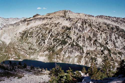 The broad unnamed Peak 8,924 from Needle Point
 The southwest hanging basin.
 The northwest bench and Needle Point.
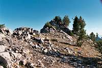 The summit.
Though this unnamed mountain is not among the highest in the Wallowa Mountains it is the highest on the divide separating the main Eagle Creek from the East Fork of Eagle Creek. It’s a bit unusual in that it possess so much bulk near the top with the steep slopes being at the middle and lower elevations giving it a raised blocky appearance. While the actual summit point is not noteworthy, there are a number of interesting features high on the mountain that would require extended time to fully experience what is offered. There are at least eight small to large lakes in the basins of this broad mountain and two or three other small ponds or saturated wetlands.
The highpoint sits on the main divide with a larger spur ridge running off to the southwest. Connecting this ridge to the main mass of the mountain is a large level to gently sloped bench that sits 1,200 feet above Eagle Lake. Between the main divide south of the mountain and the southwest ridge a hanging basin supporting beautiful tarn and undulating landscape packed with springs and meadows is situated at approximately 8,300 feet. The north side of the mountain drops off precipitously from the bench into the basin that contains Hidden Lake and its three small satellite lakes all situated in beautiful subalpine meadows and wetlands. A small northeast running spur separates this basin from the Moon Lake basin and the general east side of the mountain. This east side drops off sharply from the summit, and then spreads out into acres of gently sloped talus with a beautiful tarn above the tree line. From the northern basins it is easy to connect into the Lakes Basin and other points into the central Wallowas, however such travel would require longer extended hikes.
The mountain rises nearly 1,500 feet above Eagle Lake and 2,500 to 3,000 feet above the bottom of Eagle Creek in the middle of the main Eagle canyon. To the east the East Fork of Eagle Creek is over 3,100 feet below in the vicinity of the mountain and the summit is about 1,700 feet above the Hidden Lake Basin to the north. The mountain is composed mostly of granodiorite, but there is some brownish Hurwal Formation rocks on the bench and ridge north of the summit and a few dark basalt dikes cutting through the mountain. The mountain has 484 feet of prominence, with the connecting highpoint being Needle Point on the opposite side of Eagle Lake.
The summit itself is one of the least interesting things about this spectacular mountain, being a relatively small point that rises gradually on the main divide and supports open, stunted whitebark pine. The east side of the summit ridge does have some exposure however. There is no summit register and it is doubtful this mountain top gets many visitors. Many people do hunt in the basins found on this mountain however.
Getting There
 The approach up Eagle Creek.
The most practical route to the mountain and the only one capable of being done in a (very long) day hike is the Eagle Creek Trail 1922. To reach the Eagle Creek trailhead from Baker City and Interstate 84, get on the interstate in downtown Baker City and go north for five miles to Exit 298. Exit and turn right on Chandler Lane/OR Highway 203 (also called the Medical Springs Highway). Continue for 18 miles to the small town of Medical Springs. There are only a few buildings here. Turn right on the Big Creek road that runs southeast away from town. After approximately three miles the road enters National Forest lands and is numbered Road 67. Stay on this road for approximately 15 miles until it meets Road 77 (Eagle Road) after crossing the West Eagle Creek. Turn left on road 77 and go almost a mile. Road 77 turns away to the left, but keep straight on road 7755. Continue approximately five miles to the Main Eagle trailhead. This drive requires approximately an hour and a half from Baker City.
Trail 1922 runs approximately six miles from the Main Eagle trailhead at Boulder Park to the junction of Trail 1931 found on the south base of Needle Point. Trail 1922 turns west to Cached Lake, while 1931 turns east for another mile to Eagle Lake. This junction is very easy to miss and if one finds they have been traveling west for more than a few minutes, Trail 1931 has been missed. There is an old wood post with a fragment of a sign marking the junction, but in the brush it is very easy to miss it and the narrow track of 1931.
From Eagle Lake hike up the steep slope at the southwest corner of the lake on loose soil and gravel towards a dark outcrop almost 1,000 feet above. It is important to head for this point on the otherwise nondescript slope or more climbing than is necessary to reach the top of the ridge to the left or not getting high enough to avoid more difficult substrate to the right. As the outcrop is approached, simply go over what looks like the more level and easier way to cross the top.
Once over the top a beautiful subalpine basin is reached that provides a fairly level path to the foot of the upper summit and acres of springs, meadows and a lovely small lake to explore or camp at. Head northeast, keeping approximately on the contour and between the ridge to the left and the bottoms of the rolling basins on the right. Eventually a point will be reached where this relatively gentle slope will tie into the top of the ridge on the left. Anywhere in this vicinity is a good place to cross over into the large flat bench that sits on the northwest side of the mountain just below the summit.
 The upper portion of the route.
From here, it doesn’t matter much how the summit is achieved. One can go directly up the ridge, keeping the rugged vertical rocks on the southwest aspect in view to the right; continue north on the interesting bench, to the main divide north of the summit where views of Moon Lake, Hidden Lake and the spectacular views of Eagle Cap and Glacier Peak can be had while one turns and follows the ridge south to the top or simply go straight up the slope from anywhere on the bench.
The entire trip would require one to be on their feet for approximately 16 miles with a total ascent of almost 4,000 feet. While a long day trip is possible, it’s best to stay a night at Eagle Lake, in the valley below or on one of the nice basins high on the mountain itself.
The mountain can also be reached from the east by hiking up Trail 1910 up the East Fork of Eagle Creek about six miles, then turning up the slope in the Lawson Creek vicinity. Perhaps even better would be to continue the trail a little more then take the 1915 Trail west for a couple miles to the north basins below the mountain. Great camping can be had in this area and a number of nice scrambling routes can be found through the rugged rocks found on this side of the mountain.
Red Tape
 Moon Lake, one of five water bodies in the north basins.
The Eagle Cap Wilderness has become very popular and resource damage is becoming common in some areas. Complete regulations are available on the Wallowa-Whitman website. Some of the more important regulations to consider for a trip into the Needle Point area are listed as follows:
Entrance into the Eagle Cap Wilderness with a party of more than 12 persons and/or 18 head of stock is prohibited. Large groups multiply impacts to the wilderness and disrupt the solitude of others.
Camping within 100 feet of lakes and 100 feet of posted wetlands unless the site is designated as a campsite is prohibited.
Eagle Lake is closed to campfires due to lack of firewood and excessive impact. Campfires are prohibited within 1/4 mile (1,320 feet) of this lake. If coming from an extended hike elsewhere, especially the Lakes Basin, be aware of specific area regulations that may apply in those areas. These would be listed on the above website. It is important that all wilderness regulations and no-trace camping techniques be followed in these especially sensitive areas.
Entering the Eagle Cap Wilderness without a permit is prohibited. The free, self-issue permits are being used to collect visitor use information only. Only one permit per group is necessary. The self issue Registration/Permit boxes are located at each trailhead near the information board. Place the trailhead copy of the permit in the registration box and carry the visitor portion with you while in the wilderness. It is helpful to have the permit tied to a backpack or saddlebags where Wilderness Rangers can see them.
A Northwest Forest Pass is necessary for parking at some Eagle Cap Wilderness Trailheads, including Eagle Creek. These mandatory passes cost $30 per year, or $5 per day, and are for sale at all Wallowa-Whitman National Forest Offices, the Wallowa Mountains Visitor Center in Enterprise, or at local businesses in the towns of, Wallowa, Enterprise, Joseph, Wallowa Lake, La Grande, Elgin and Baker City. Northwest Forest Passes may also be available at commercial outlets and national forest offices in other locations around Oregon and Washington. The passes will allow visitors to park at many other national forest trailheads across Washington and Oregon.
Camping
 Hidden Lake.
There are no developed campgrounds in the Eagle Cap Wilderness, but at large camping is allowed basically anywhere. However, camp in the trees if possible and avoid meadows and places easily trampled. Good camping locations are scarce in the lower end of the Eagle Creek basin, but starting near the 1921 trail junction (about four miles up) some descent camping spots can be found.
The closest camping to the mountain is at Eagle Lake, which fills the large cirque on the north base of the mountain. Unfortunately opportunity is severely limited to a couple spots on the extreme west end. These are tight and because they are so close to the lake, campfires are not allowed. If you do not need one and you can get a spot, this is an exceptionally beautiful setting. Though they are harder to get to a couple excellent camping options can be found high up the mountain itself. On the northwest side of the mountain a large bench with water just below the summit provides incredible views of Eagle Lake and Needle Point and points beyond. The south bowl of the mountain is made up by a series of moist basins with year around water and one large swimming pool-like tarn surrounded by flat ground with several good tent sites. This is a fantastic place if you don’t mind packing camp up the steep slope from Eagle Lake. The wear on the ground indicates that the mountain goats spend a lot of time here.
For those spending more time in the general area camping can be found at Lookingglass Lake, Culver Lake or Bear Lake, which are located between one to two and a half miles up the 1921 trail. There are campgrounds at the Main Eagle trailhead; Two Color, about four miles before the trailhead and Tamarack less than a mile east on the 77 road after its first junction with road 67.
When To Climb
Most people climb this mountain in the summer or fall. Getting here in the spring or winter would be a serious chore and impossible unless one was skilled at extended back country winter travel. Avalanche danger on most of this mountain would be high. In the summer come prepared for a variety of weather conditions regardless of the forecast. Local weather can change suddenly and be severe at any time.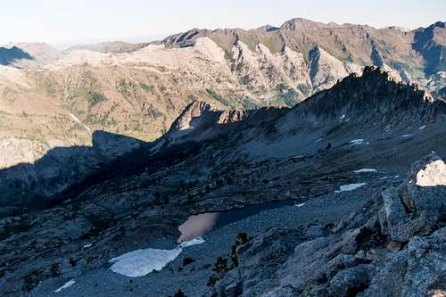 Small tarn and the East Fork Eagle Canyon.
Mountain Conditions and Information
Wallowa-Whitman National Forest HeadquartersP.O. Box 907 / 1550 Dewey Avenue
Baker City, Oregon 97814
(541) 523-6391
TDD (541) 523-1405
Wallowa Mountains Office and Visitor Center
Eagle Cap Ranger District
Wallowa Valley Ranger District
88401 Hwy. 82
Enterprise, OR 97828
(541) 426-4978
(541) 426-5546 TDD (541) 426-5609
La Grande Ranger District
3502 Hwy. 30
La Grande, Oregon 97850
(541) 963-7186
Visit the Wallowa-Whitman National Forest webpage for current conditions including weather, advisories or other valuable information.
NOAA Forecast
 Unnamed lake, southwest basin.