
|
|
Mountain/Rock |
|---|---|
|
|
45.16369°N / 117.30162°W |
|
|
Union |
|
|
Hiking, Mountaineering |
|
|
Spring, Summer, Fall, Winter |
|
|
9572 ft / 2918 m |
|
|
Overview
Eagle Cap is a popular summit destination in northeastern Oregon. The peak is notable as the highest point of Union County but is most famous as being the centerpiece of the Eagle Cap Wilderness and Wallowa Mountains. Although the mountain is not the highest or most prominent within the region, it can be seen from many different valleys and peaks. The views of Eagle Cap looming above the south side of Lake Basin might be amongst the most photographed of any peak located within the Wallowa Mountains if not the entire state. Similarly, the 360-degree views from the summit are amongst the best within the Wallowa Mountains if not the entire state.
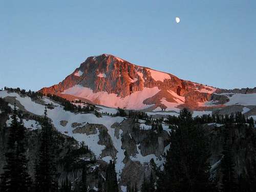 Eagle Cap
The standard approaches for Eagle Cap are considered non-technical. Snow lingers throughout most of Summer along the upper north-facing sections of the route, so extra caution should be taken as such. During primary hiking season (mid-August through October), the standard approaches are merely trail hikes.
Despite being a non-technical peak, the shortest standard approach is approximately 20 miles roundtrip with 4100'-4400' cumulative elevation gain. Many summiters are able to do the entire roundtrip hike within one day but most opt to stay overnight. The latter option is recommended and definitely has its advantages, primarily by lessening the amount of single-day hiking as well as enjoying the picturesque scenery of the region.
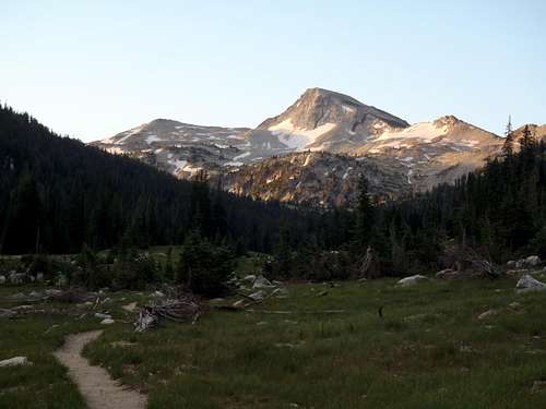 Eagle Cap, as seen from East Lostine River Valley
Technical climbs of Eagle Cap are possible but seldom done. The steep north and east faces of the peak offer possibilities of rock climbing and/or ice travel. The south slopes are very steep and rugged, and also offer opportunities for rock climbing and scrambling for those motivated enough to do so.
Eagle Cap originally got its name from early pioneers and visitors who erroneously thought the peak was the highest point within the Eagle Mountains range. The range name eventually changed to the Wallowa Mountains and multiple other peaks within the range have since been proven to be higher than Eagle Cap, yet the peak name has remained unchanged.
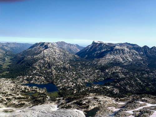 Vast views from high summit of Eagle Cap
Standard Approaches
Multiple trails are near Eagle Cap but there are three standard approaches:
-> East Lostine River Trail #1662
-> Hurricane Creek Trail #1807
-> West Fork Wallowa River Trail #1820
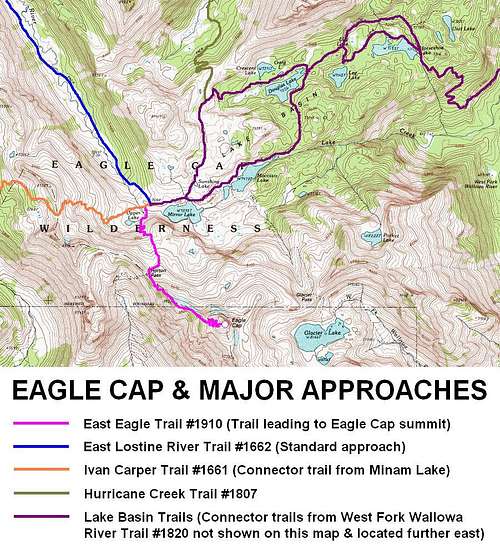 Standard Approaches Converging Near Eagle Cap
------------
GENERAL ROUTE DESCRIPTIONS:
EAST LOSTINE RIVER TRAIL #1662:
This route provides the shortest approach to Eagle Cap. However, the roundtrip hike is still approximately 20 miles and 4100'-4400' cumulative elevation gain. Visitors should allow two days for this route, although many hikers are able to complete the entire summit hike in one long day.
-> Starting at Two Pan Trailhead, follow the East Lostine River Trail #1662 southbound approximately 7.3 miles until entering Lake Basin.
-> Just prior to reaching Mirror Lake, turn right (west) onto Ivan Carper Trail #1661 (but might also be signed for Horton Pass and/or Eagle Cap).
-> Within 100 yards hiking distance, reach another trail junction and turn left (south) onto East Eagle Trail #1910 towards Horton Pass and Eagle Cap.
-> Follow East Eagle Trail #1910 approximately 2.7 miles to the summit. The trail veers left (east) of Horton Pass and ascends the northwest ridge of the peak.
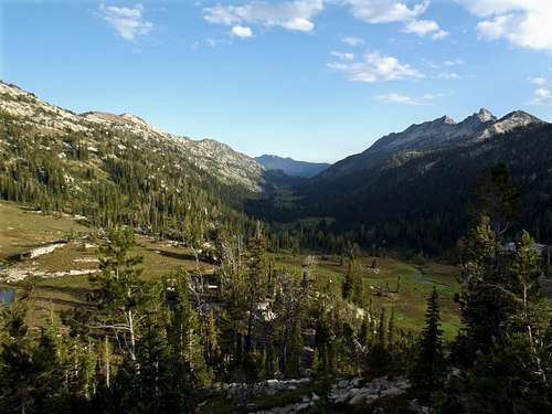 East Lostine River Valley, as seen from Eagle Cap
Route Variation:
It is feasible that East Lostine River Trail #1662 can be combined with Ivan Carper Trail #1661 (which is a connector trail between Mirror Lake and Minam Lake) and Minam Lake Trail #1670 as a big loop trip. This is because Trail #1662 and #1670 both originate at Two Pan Trailhead. This loop is shown on a general Forest Service document at this link. This route variation adds approximately 2-3 miles and 1000'-1200' cumulative elevation gain to the overall Eagle Cap trip.
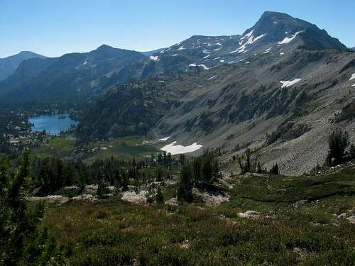 Eagle Cap, as seen from connector trail between Minam & Mirror Lakes
------------
HURRICANE CREEK TRAIL #1807:
This route is longer than the East Lostine River approach. The roundtrip hiking distance is approximately 30 miles. Visitors should allow 2-3 days for this route. One advantage of this approach is the Hurricane Creek Trail passes by the Thorp Creek route for Sacajawea Peak, the highest point in northeast Oregon. However, hikers should allow 3-5 days if trying to combine both peaks (Sacajawea Peak, Eagle Cap) in the same trip.
-> Starting at Hurricane Creek Trailhead, follow the Hurricane Creek Trail #1807 southbound approximately 10.1 miles until its end-junction with Lake Basin Trail #1810.
-> Turn right (west/southwest) onto Lake Basin Trail #1810. Hike westbound along Lake Basin Trail #1810 for approximately 2.2 miles.
-> Once beyond the west side of Mirror Lake, begin looking for the trail junction of Ivan Carper Trail #1661, Horton Pass, and/or Eagle Cap.
-> Turn right (west) onto Ivan Carper Trail #1661 (but might also be signed for Horton Pass and/or Eagle Cap).
-> Within 100 yards hiking distance, reach another trail junction and turn left (south) onto East Eagle Trail #1910 towards Horton Pass and Eagle Cap.
-> Follow East Eagle Trail #1910 approximately 2.7 miles to the summit. The trail veers left (east) of Horton Pass and ascends the northwest ridge of the peak.
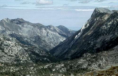 Hurricane Creek Valley, as seen from Eagle Cap
------------
WEST FORK WALLOWA RIVER TRAIL #1820:
Of the three standard approaches to Eagle Cap, this route is the longest but perhaps arguably the most interesting. The roundtrip hiking distance is approximately 34 miles, with possible alternate trail variations within Lake Basin increasing the mileage if desired. This approach traverses up the West Fork Wallowa River valley, surrounded by some of the highest peaks within the Wallowa Mountains (such as Sacajawea Peak, Matterhorn, Hurwal Divide, etc.). Then the route heads west through the heart of Lake Basin, one of the most popular areas within Eagle Cap Wilderness. Visitors should allow 2-3 days for this route. It is possible to add other summit attempts to this route, such as for Sacajawea Peak or Matterhorn, but hikers should allow 3-5 days if trying to combine other peak destinations in addition to Eagle Cap for this route.
-> Starting at Wallowa Lake Trailhead, follow the West Fork Wallowa River Trail #1820 southbound approximately 6.0 miles until its junction with Lake Basin Trail #1810 at Six Mile Meadows.
-> Turn right (west) onto Lake Basin Trail #1810. Hike westbound along Lake Basin Trail #1810 for its entire length (8.3 miles), until just beyond Mirror Lake.
SIDE-NOTE: For reference purposes, the mileage from Six Mile Meadows to Horseshoe Lake (the first lake encountered in Lake Basin) is approximately 3.0 miles. The mileage from Horseshoe Lake to Mirror Lake is approximately 5.3 miles.
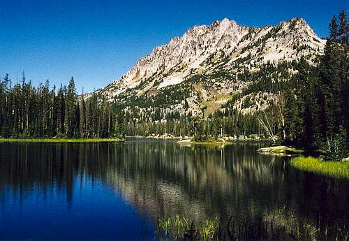 Horseshoe Lake, on the east side of Lake Basin
-> Once beyond the west side of Mirror Lake, begin looking for the trail junction of Ivan Carper Trail #1661, Horton Pass, and/or Eagle Cap.
-> Turn right (west) onto Ivan Carper Trail #1661 (but might also be signed for Horton Pass and/or Eagle Cap).
-> Within 100 yards hiking distance, reach another trail junction and turn left (south) onto East Eagle Trail #1910 towards Horton Pass and Eagle Cap.
-> Follow East Eagle Trail #1910 approximately 2.7 miles to the summit. The trail veers left (east) of Horton Pass and ascends the northwest ridge of the peak.
Driving Directions
TWO-PAN TRAILHEAD (for East Lostine River Trail #1662):
IF APPROACHING FROM THE WEST:
-> Starting at the intersection of Interstate 84 and Highway 82 in the city of La Grande (OR), drive east along Highway 82.
-> After 53.5 miles along Highway 82, when passing through the town of Lostine, turn right (south) onto Lostine River Road.
IF APPROACHING FROM THE EAST:
-> Starting at the intersection of Highway 82 & Highway 3 in the town of Enterprise (OR), drive north along Highway 82.
-> After 10 miles along Highway 82, when passing through the town of Lostine, turn left (south) onto Lostine River Road.
REST OF DRIVE (REGARDLESS OF STARTING POINT):
-> After seven miles along Lostine River Road, the National Forest boundary is reached and the road name changes to Forest Road 8210.
-> Continue following Forest Road 8210 for another 11 miles (or 18 miles from Highway 82) until reaching the parking area at the road-end.
IMPORTANT: Forest Road 8210 is a dirt & gravel road, and narrow in some sections.
------------
HURRICANE CREEK TRAILHEAD (for Hurricane Creek Trail #1807):
-> Starting at the intersection of Highway 82 & Highway 3 in the town of Enterprise (OR), drive south along Highway 82.
-> After 0.4 miles along Highway 82, where the highway makes a distinct left bend, veer straight/right onto Hurricane Creek Road.
-> After 5.1 miles along Hurricane Creek Road, veer right onto County Road 521 / Forest Road 8205.
-> Continue following County Road 521 / Forest Road 8205 for nearly four miles until reaching the parking area at the road-end.
IMPORTANT: Forest Road 8205 is a dirt & gravel road, and rough & narrow in some sections.
------------
WALLOWA LAKE TRAILHEAD (for West Fork Wallowa River Trail #1820):
-> Starting at the intersection of Highway 82 (Main Street) and Highway 350 (East Wallowa Avenue) in the town of Joseph (OR), drive south along Main Street towards Wallowa Lake.
SIDE-NOTE: For reference purposes, Main Street becomes Highway 351 south of this initial road intersection in Joseph.
-> After 0.6 miles, Highway 351 bends to the left. Follow the highway.
-> Continue following Highway 351 for approximately 6.4 miles further (or approximately seven miles from the initial road intersection in Joseph), along the eastern shore of Wallowa Lake and until reaching the parking area at the road-end.
SIDE-NOTE: For reference purposes, the road-end occurs approximately one mile from the southern shore of Wallowa Lake.
Red Tape
Parking at all trailheads, most established campgrounds, and some picnic areas within the Wallowa-Whitman National Forest requires a regional pass (Northwest Forest Pass). The current cost of the pass is $5/day or $30/year. Golden Age & Golden Access Passport holders may purchase the pass at a 50% discount. However, the Golden Eagle Passport does not apply to the Northwest Forest Pass. Click here to find where one can be obtained in this region.
-> EXCEPTION: No Northwest Forest Pass is currently required at the Wallowa Lake Trailhead.
All visitors to Eagle Cap Wilderness must obtain a Wilderness Permit prior to any hike in the area. Wilderness Permits are free, self-issued, and available at all major trailheads within the area.
There is a group size limit within Eagle Cap Wilderness. Currently, groups are limited to a maximum of 12 people for trail hiking and a maximum of six people for overnight camping.
Equestrian use is allowed but horse stops must be a minimum of 200' from any lakeshore.
Pets are allowed but must always be leashed (6' maximum length).
When To Climb
Eagle Cap can potentially be climbed year-round. However, nearly all summiters do so June through October. The optimum timeframe for climbing the peak is from late July through September, when enough mountain snow has melted to allow safe and straightforward travel.
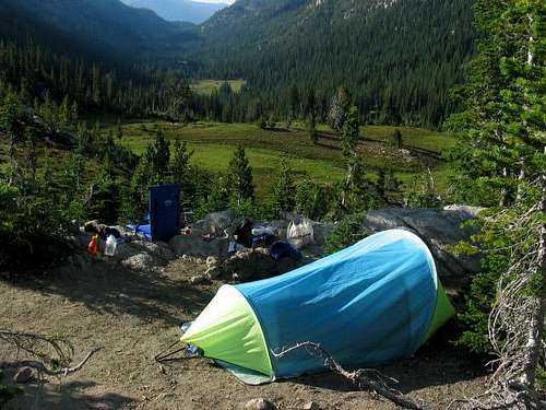
Camping
Camping is permitted within Eagle Cap Wilderness. Most summiters of Eagle Cap who camp overnight do so within Lake Basin, immediately north of the peak.
Camping must be a minimum of 100' from any lakeshore, and only at established campgrounds.
Campfires must be a minimum of 100' from any lakeshore or posted wetlands, except campfires must be a minimum of 1/4-mile (1320') of the following lakes:
Bear Lake, Blue Lake, Chimney Lake, Dollar Lake, Eagle Lake, Frazier Lake, Little Frazier Lake, Glacier Lake, Hobo Lake, Ice Lake, Jewett Lake, Laverty Lake, Maxwell Lake, Mirror Lake, Moccasin Lake, Prospect Lake, Steamboat Lake, Sunshine Lake, Swamp Lake, Tombstone Lake, Traverse Lake, Upper Lake
Eagle Cap Wilderness has a "Leave No Trace Behind" policy for visitors.
------------
TRAILHEAD CAMPING:
-> TWO-PAN TRAILHEAD: Eight established campsites. All campsites are on a "first come, first served" basis.
-> HURRICANE CREEK TRAILHEAD: No tent camping. The nearest official campsites are found at Hurricane Creek Campground, located approximately 1.5 miles north of (before) the trailhead along Forest Road 8205.
-> WALLOWA LAKE TRAILHEAD: No camping. No campsites. The nearest campsites are found at Wallowa Lake State Park, located approximately one mile north of the trailhead. Reservations are required for camping at Wallowa Lake State Park during Summer season.
Mountain Conditions
Local Forest Service road conditions are found at this link.
Local trail conditions are found at this link.
------------
Forest Service webpages are not always updated on a consistent basis. It is highly recommended to contact a local ranger station for last known road and/or trail conditions.
EAGLE CAP RANGER DISTRICT
STREET ADDRESS: 201 East Second Street, Joseph, OR 97846
MAILING ADDRESS: P.O. Box 905, Joseph, OR 97846
TELEPHONE NUMBERS: 541-426-5546, 541-426-4978
FAX NUMBER: 541-432-0693