Approach
Mt. Heyburn’s serrated southeast ridge and twin summits dominate the skyline above Redfish Lake. A picturesque couloir severs the North Face and separates the east and west summits
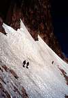
From Redfish Lake (6500 ft) , follow the Bench Lakes trail to the uppermost Bench Lake (8600 ft). It will be 5 miles to the uppermost Bench Lake and the trail will slowly get more faint as you ascend. The Bench Lakes make excellent camp spots if you need to camp (we didn't). Hike around the south side of the lake and look for the very prominent couloir that divides Heyburn's East and West Summit. The West Summit is a few feet taller, but both summits are amazing and require serious skills to summit. Traverse the snow (we did this in June) and make your way up the couloir.
Route Description
Initially the climb is not real steep and we didn't rope up. After your about 50% of the way up the couloir the angle steepens dramatically. We roped here and started placing pickets. As the day warmed, the snow soften and we encountered an exposed rock section peaking through the melted snow, perfectly featureless. A rock climbing move or short aid pull gets you above this (depending on the time of season). Above this, the snow was very loose and rolling off. The gulley divides into two similar looking chutes. We choose the left chute, but either go. The left may be slightly more difficult, depending on the conditions. Soon you climb through a rock hole and emerge at a wonderful saddle between the East and West Summits. Now your at 9900 feet at this point. There's a route to each summit here. Since I've already done the famous Stur Chimney (which leads to the west summit), we decided to go up the East Summit. Notice the original pitons and old hangers on the East route of the West Summit route. From here scramble over Class 4 and Easy Class 5 terrain (300 feet) to reach the East Summit. Stay first on the south side, then cross over to the north. The last 20 feet may require a couple of easy fifth-class moves. We didn't rope up for this. The only logical descent is a rock scree gulley going down the south side. Retrace your steps to the saddle, then descend scree-filled gullies that snake down the mountain’s south face. Pick up the Redfish Creek Trail and return to the car.This goes very quickly to the Redfish Creek trail, which you can take to the Redfish Shuttle Boat transfer station and take a 5 mile boat ride out (fee), or hike the 5 miles around Redfish Lake on the prominent lateral morraine.
Essential Gear
Cramp-ons, Ice Axe, Glacier Rope, Alpine Harness, Picketts, Ice Screws, Slings
History
Although details of the first ascent are sketchy, the now legendary Paul Petzoldt climbed this thin ribbon of snow and ice in 1947, and soon afterward climbers began referring to it as the Petzoldt Couloir. Petzoldt climbed the slightly higher west summit, but unless you enjoy thrashing on rotten granite, set your sights on the slender and exposed pinnacle to your left.

 13656 Hits
 72.08% Score
 2 Votes