Post GPX bugs or feature requsts here
-

Gangolf Haub - Forum Moderator
- Posts: 9436
- Joined: Wed Nov 12, 2003 4:28 pm
- Thanked: 1046 times in 753 posts
Re: Post GPX bugs or feature requsts here
Hi Matt - I think this wonderful feature could also be useful on trip reports. Quite often members post route statistics and route profiles on the tr. It'd be nice to see the gps track as well.
-

Michael Hoyt - Posts: 86
- Joined: Tue Sep 13, 2005 9:43 pm
- Thanked: 0 time in 0 post
Re: Post GPX bugs or feature requsts here
Matt,
I'd like to see this feature added to mountain pages also. Unless a mountain has three or more routes to the summit, I seldom produce separate route pages. You're welcome to look at some of my mountain pages to see how I handle 1-2 routes to a summit.
Mike
I'd like to see this feature added to mountain pages also. Unless a mountain has three or more routes to the summit, I seldom produce separate route pages. You're welcome to look at some of my mountain pages to see how I handle 1-2 routes to a summit.
Mike
-

MoapaPk - Posts: 7780
- Joined: Fri May 13, 2005 7:42 pm
- Thanked: 787 times in 519 posts
Re: Post GPX bugs or feature requsts here
I tried it for two routes that I own, and it seems to work well.
Two things I noticed: 1) The embedded GPX stuff for route color often does not translate well on Google -- not your problem, and I don't see a way to fix. For example, on Keystone Canyon page, the map shows the hiking/climbing route in red, and the road in a slightly magenta-pink shade of red. 2) The zoom bar doesn't give one much chance for a close-up, but I don't see this as much of a problem -- that's what the download and the route instructions are for.
I agree that it would be nice on mountain pages as well.
People should realize that "google maps" uses a fairly coarse DEM, so it will portray some actual climbing stuff in a bizarre way. Even with the finest DEM selected, google earth will still give areas like Castle Peaks deceptive simplicity (that is a GPX that I just uploaded as an "image" file). But I would think that anyone who uses a GPX should know this stuff, just as everyone who carries an ice axe can self-arrest on a dime .
Perhaps it is time for someone to write an article on ways people screw up with GPS. I nominate Moni. (Stuff I've seen: wrong datum (display only, when calling SAR), not letting the unit settle, failure to track the estimated uncertainty, reflected waves, failure to carry spare batteries, not understanding what +/- 10' uncertainty means on cliffs, not realizing that the simplest GPS "compass" doesn't work when you stop, failure to realize that the GPS truncated a long file.)
-
MoapaPk - Posts: 7780
- Joined: Fri May 13, 2005 7:42 pm
- Thanked: 787 times in 519 posts
Re: Post GPX bugs or feature requsts here
Red is great-- but some gpx files have several routes with different color tags for each route. I guess we just accept that they will all be reddish on the map, and let the actual downloaded file distinguish between "approach road" and "hike/climb." Out here, finding the gravel/rock road in may be as tricky as finding the human-powered route!
-

visentin - Posts: 1442
- Joined: Sun Jan 13, 2008 12:27 pm
- Thanked: 88 times in 58 posts
Re: Post GPX bugs or feature requsts here
Hello Matt,
I don't know if you came across this article :
http://www.summitpost.org/article/57875 ... outes.html
neither if it had any influence about deciding to integrate this feature to SP.
Congrats again for integrating it in SummitPost, which makes somehow our article suddenly odd
However I see a great way to make SP stand over the average compared to other outdoor sites that integrate route features.
Google maps are not so precise and do not fully show all details. On the other hand more and more coutries in the world (US included !) have a map editor whose portal allows displaying the GPX routes on real maps background. Apart from US, there are a half dozen of such countries in Europe and they are going to be more and more numerous I guess.
Here is my idea: why not proposing, while displaying a route, to draw it either on Google maps or the map background of the country the route belongs to.
Here is a good example of what it could be :
http://philrando.free.fr/GoogleMaps/est ... -azet.html
If you click on "visualisation avec Géoportail" you switch from the Google maps view to the IGN maps view (that's the french maps for this very example).
The inconvenient is that there would be as many maps applets to develop and maintain as there are countries/map editors, but the challenge would be great in order to keep SP high above the rest.
What do you think ?
Eric
-

WouterB - Posts: 3134
- Joined: Fri Jan 11, 2008 4:54 pm
- Thanked: 13 times in 13 posts
Re: Post GPX bugs or feature requsts here
Display meters as well as feet and I would use it.
-
visentin - Posts: 1442
- Joined: Sun Jan 13, 2008 12:27 pm
- Thanked: 88 times in 58 posts
Re: Post GPX bugs or feature requsts here
Montana Matt wrote:I suppose it could be done, but if there are multiple mapping applets that need to be used for different places all over the world, programming that could be tedious and time consuming.
Yes, that's what I expressed my fears about. especially for Europe. No unique map editor....
Montana Matt wrote:In my opinion, Google Maps isn't all that bad. It definitely gives you a very good idea of the terrain and what you might be up against.
If there were a single applet that had topomaps for the entire world, I'd be all for adding that applet to SummitPost, but it doesn't sound like that's the case, right?
No, but you could give a first try for example implementing only the US/Canada maps. More than half of the SP objects are in North America so this would definitely be worth a try.
Have a look again to section 7 of the page I mentionned where member Jelf detailled how to implement it for mappingsupport.com :
http://www.summitpost.org/article/57875 ... #chapter_7
What's more, mappingsupport.com is one of the easiests GPX map displayers to implement and embed. Just an iFrame where the URL of the KML (file of the Google route) is specified. Shouldn't be much work !
As for Europe, there are a couple of countries for which it would be as easy as for mappingsupport, some not.
France and UK, the two biggest, would require unfortunately some developping behind. The only one I see easy to do as quick as mappingsupport would be Slovakia, but it is far to be the biggest country.
And as for the most popular mountainous European countries present on SP, let's understand countries in which the Alps are located, neither Germany neither Austria, Switzerland or Italy have such system to display GPX routes. So perhaps it's not time yet to invest too much effort in Europe.
In my opinion what you could do is just give it a first try with US/Canada. Let's see how users will react, and if the opinion is positive maybe this will encourage to have more maps in the future. I'm pretty optimistic about everyone's feedback.
-
visentin - Posts: 1442
- Joined: Sun Jan 13, 2008 12:27 pm
- Thanked: 88 times in 58 posts
Re: Post GPX bugs or feature requsts here
Another thing I thought about concerning this GPX feature is that many routes are already present on SP, not to say all popular routes for some areas.
Considering that only new routes, from the moment the GPX feature was available, will possibly contain a GPX route, the risk is that only a very marginal amount of routes on SP will ever contain GPS data.
Of course it is always possible to contact the owner and propose the route, but for many old pages many owners do not connect regularly, and many newcomers having routes will not mind immediately about doing this procedure in order to append their GPXes.
Perhaps the idea of providing GPX data for existing routes should be considered in order to fill progressively the blanks.
I see several ways to do that but each has advantages and inconvenients :
- Anyone could append a GPX to an existing route as long as there is none. But how to control if the GPX is a good one, and how to remove it in case of mistake
- Anyone could append a GPX to an existing route, and the owner gets a notification in order to check if the route really matches with the page content. Perhaps such notifications could be grouped in the profile page into a folding frame, like the comments and replies, under the title "GPX routes to approve"
- Perhaps GPX routes should simply be a new type of object, that, just like images, we attach to other kind of objects (the advantage would be to use it both for a route, a TR like Gangolf mentionned, or even a peak ?) A question in this case, would several GPXes be attached to one object ? (maybe the page reader would enjoy having the choice between several traces of various quality ?)
That's in my opinion a good topic to be meditated before extending the feature !
Eric
-

peterbud - Posts: 213
- Joined: Thu Jan 04, 2007 11:12 am
- Thanked: 6 times in 4 posts
Re: Post GPX bugs or feature requsts here
visentin wrote:- Perhaps GPX routes should simply be a new type of object, that, just like images, we attach to other kind of objects (the advantage would be to use it both for a route, a TR like Gangolf mentionned, or even a peak ?) A question in this case, would several GPXes be attached to one object ? (maybe the page reader would enjoy having the choice between several traces of various quality ?)
Eric
Worth to think about.
-
visentin - Posts: 1442
- Joined: Sun Jan 13, 2008 12:27 pm
- Thanked: 88 times in 58 posts
Re: Post GPX bugs or feature requsts here
peterbud wrote:visentin wrote:- Perhaps GPX routes should simply be a new type of object, that, just like images, we attach to other kind of objects (the advantage would be to use it both for a route, a TR like Gangolf mentionned, or even a peak ?) A question in this case, would several GPXes be attached to one object ? (maybe the page reader would enjoy having the choice between several traces of various quality ?)
Eric
Worth to think about.
From the moment I wrote that, I thought about it again.
I'm not sure if several GPX make sense, unless we allow displaying them all at once, which would give the user an "average trace" overview (that would be interesting for routes on wide terrain where orientation is needed, when the route needs to be optimized, or if one guy did a mistake during the recording of his route, like going back on his footprints for a while).
Otherwise, for ONE gpx in the same time, the best and probably most simple, assuming we allow anyone to append a GPX, would be that the upload GPX option is visible as long as there is none, and that the GPX could be removed either by the person who uploaded it or the page owner.
May I suggest also to advertise more the GPX feature in the front page ? Nobody seem to have noticed it, and that's in my opinion the biggest improvement of SP since long (well since I know it...)
-
peterbud - Posts: 213
- Joined: Thu Jan 04, 2007 11:12 am
- Thanked: 6 times in 4 posts
Re: Post GPX bugs or feature requsts here
visentin wrote:I'm not sure if several GPX make sense, unless we allow displaying them all at once
It does make sense, if the files would be downloadable from their map page.
Of course, simultaneous display of multiple routes would be a nice feature as well.
-
Gangolf Haub - Forum Moderator
- Posts: 9436
- Joined: Wed Nov 12, 2003 4:28 pm
- Thanked: 1046 times in 753 posts
Re: Post GPX bugs or feature requsts here
Matt, one more suggestion:
the route profile has the statistics placed in one line above the elevation profile. I think it would be better arranged as a list (beside or below the graph). I have occasionally uploaded screenshots from a German site which look like this:
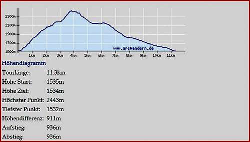
the route profile has the statistics placed in one line above the elevation profile. I think it would be better arranged as a list (beside or below the graph). I have occasionally uploaded screenshots from a German site which look like this:
-
MoapaPk - Posts: 7780
- Joined: Fri May 13, 2005 7:42 pm
- Thanked: 787 times in 519 posts
Re: Post GPX bugs or feature requsts here
Gangolf Haub wrote:Matt, one more suggestion:
the route profile has the statistics placed in one line above the elevation profile. I think it would be better arranged as a list (beside or below the graph). I have occasionally uploaded screenshots from a German site which look like this:
It don't know it it should be automatic, because gpx files are not guaranteed to have real elevation data. If the file has been post-edited (say to remove random spikes in a deep canyon), the elevation of the smoothed and filled-in points may be 0. If it is not edited to remove artifacts in deep canyons, the elevations of said points may be totally ersatz. If the file was saved to another (older) format before the gpx (say txf), there's a good chance it won't have any elevation data.
-

Lolli - Posts: 810
- Joined: Mon Apr 05, 2010 7:56 pm
- Thanked: 112 times in 71 posts
Re: Post GPX bugs or feature requsts here
What exactly is gpx-files?
Something I can download to a GPS?
To a rental car GPS too?
Something I can download to a GPS?
To a rental car GPS too?
Age is a matter of mind and if you don´t mind it does not matter!
-
MoapaPk - Posts: 7780
- Joined: Fri May 13, 2005 7:42 pm
- Thanked: 787 times in 519 posts
Re: Post GPX bugs or feature requsts here
Lolli -- you can upload the tracks in a gpx file, from your computer, to a GPS. I don't know if the most recent GPSs can take a direct load of the entire file. In the past, one would open the gpx file in application (even google earth can do some of this), then choose the tracks or waypoints that one wishes to load on the GPS. There are free applications that will let you load tracks from a list; the ones that show the tracks on a map first are usually shareware at least. Garmin GPSs come with a program MapSource, that will allow one to put tracks on the GPS, or read tracks from the GPS.
The above is for hand-held GPS with a computer port. I'm not sure how many car GPS systems have a data port.
Old school:
http://hwstock.org/gps/
The above is for hand-held GPS with a computer port. I'm not sure how many car GPS systems have a data port.
Old school:
http://hwstock.org/gps/
-
- Related topics
- Replies
- Views
- Last post
-
- New Feature: Auto Cross post Photos to Parent page
by atavist » Mon Sep 19, 2011 5:50 am - 0 Replies
- 1550 Views
- Last post by atavist

Mon Sep 19, 2011 5:50 am
- New Feature: Auto Cross post Photos to Parent page
-
- Report Bugs Here
1 ... 78, 79, 80") by Bob Sihler » Sat Sep 25, 2010 1:56 pm
by Bob Sihler » Sat Sep 25, 2010 1:56 pm
- 1187 Replies
- 339072 Views
- Last post by nader
Fri Mar 15, 2024 3:11 pm
- Report Bugs Here
-
- bugs in MBpost (and SP ?)
1, 2by visentin » Tue Jun 18, 2013 2:04 pm - 24 Replies
- 23303 Views
- Last post by Diego Sahagún
Tue May 19, 2015 12:48 pm
- bugs in MBpost (and SP ?)
-
- Missing GPX file
by pauljurczak » Mon Aug 05, 2019 12:20 am - 0 Replies
- 4150 Views
- Last post by pauljurczak
Mon Aug 05, 2019 12:20 am
- Missing GPX file
-
- GPX track store?
by tdkehoe » Fri Jan 30, 2015 7:21 pm - 0 Replies
- 4589 Views
- Last post by tdkehoe
Fri Jan 30, 2015 7:21 pm
- GPX track store?
Who is online
Users browsing this forum: No registered users and 1 guest