Routing with GPS

-

neghafi - Posts: 196
- Joined: Sat Feb 23, 2008 11:42 am
- Thanked: 1 time in 1 post
because sometimes you may have multiple routes that share a section. I'm lazy and I don't like to do it by choice. anyway there is no other choice.
I thought I may be possible that GPS treat with routes like a (city) network and do a simple navigation like it does routing by a map.
I thought I may be possible that GPS treat with routes like a (city) network and do a simple navigation like it does routing by a map.
-

Moni - Posts: 2242
- Joined: Mon Aug 12, 2002 11:15 am
- Thanked: 4 times in 3 posts
MoapaPk wrote:Moni wrote:Okay, I buy into that, but can it do that with routes? I think the intent of the question is to use a stored series of waypoints, to create a multi-segmented route. Not so sure that's feasible.
Yes, I agree. I guess the problem is that he is doing this on the fly, but I can't quite figure out why it must be done that way.
Knowing what I know about GIS and its programming (and GPS treats tracks and routes similarly), it has to do what it does to create lines and polygons. The GPS itself just collects positions. It's the software that instructs it to either (1) leave the positions as is or average them into a single point (2) connect the positions with a line segment (3) do the former, but upon closure connect the last position to the first to close it (mostly in order to calculate area) Thus the multibranch figure is a bit above its ability. It would require (as GIS does) a database in the background that would allow multiple lines to be viewed as one layer and would allow those segments to have other segments in common. The software maps as well as full blown GIS can be uploaded into a GPS, but you just can't do this on the fly. For that, you would need something more on the order of regular computer with the software and interactive capabilities of mapping software. Trimble makes those - they are basically handheld computers with GPS capabilties, but a touch pricey (JUNO's start at 1500$ plus software)
-

Diego Sahagún - Posts: 14465
- Joined: Sun Oct 07, 2001 6:21 pm
- Thanked: 748 times in 682 posts
Re: Routing with GPS
neghafi wrote:Many mountains has not only one safe route on a face and some routes may joints each other a share a part of them.
Till now, I create each route separately so I have 2 (or more) routes on the shared section (right). I want to know if I split such Routes at shared section and create a only one route in that part then I'm still able to use routing functions only in 1 stage. (left)
This needs GPS can join virtually 2 (or more) routes but make it easy for me to creating routes specially with long shared part.
I'm not sure if it's possible so I asked if anyone knows. btw I use colorado300 if it matters
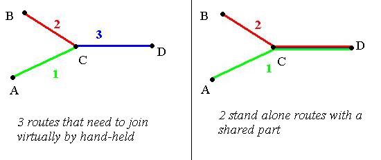
neghafi, I think that the problem is that in the right draw both routes don't have the same waypoints on the C-D section, so it wouldn't be impossible to join them
-
neghafi - Posts: 196
- Joined: Sat Feb 23, 2008 11:42 am
- Thanked: 1 time in 1 post
Possible as like in routable maps. routable maps has separate links (roads) and when defining destination the GPS will try to find the shortest path (of roads) to the destination. it means that, it can find all reasonable routes to destination and find the shortest.
Now just imagine if it can do a same thing (finding reasonable routes) by using routes instead of roads.
It is possible!
Now just imagine if it can do a same thing (finding reasonable routes) by using routes instead of roads.
It is possible!
-
- Related topics
- Replies
- Views
- Last post
-
- GPS for a dog?
1, 2, 3by tigerlilly » Thu Jun 10, 2010 7:08 pm - 38 Replies
- 17708 Views
- Last post by tigerlilly

Mon Jun 14, 2010 7:21 pm
- GPS for a dog?
-
- Found GPS
by Lynn Coburn » Tue Apr 10, 2018 11:41 pm - 0 Replies
- 1953 Views
- Last post by Lynn Coburn
Tue Apr 10, 2018 11:41 pm
- Found GPS
-
- Downloading Maps onto GPS
by Hazelroth » Fri Jun 04, 2010 12:04 am - 5 Replies
- 2145 Views
- Last post by Hazelroth
Fri Jun 04, 2010 5:47 pm
- Downloading Maps onto GPS
-
- GPS compatability in the S. hemisphere
1, 2by skyward22 » Wed Dec 02, 2009 9:36 pm - 20 Replies
- 19370 Views
- Last post by dkoehne
Thu Dec 03, 2009 7:34 pm
- GPS compatability in the S. hemisphere
-
- GPS tracks for mountains worldwide?
by nothingmaster » Sun Feb 23, 2014 4:10 am - 2 Replies
- 2226 Views
- Last post by nothingmaster
Sun Feb 23, 2014 6:33 pm
- GPS tracks for mountains worldwide?
Who is online
Users browsing this forum: No registered users and 0 guests