
|
|
Route |
|---|---|
|
|
37.94406°N / 105.55956°W |
|
|
Scrambling |
|
|
Summer, Fall |
|
|
One to two days |
|
|
Class 3 |
|
|
III |
|
|
Overview
(Because the route goes from the summit of Tijeras Peak to the summit of Pico Asilado, I have attached it to both peak's pages, as the route could be reversed as a means to climb Tijeras Peak as well as a way to climb Pico Asilado.)Pico Asilado is a dramatic summit just south of the Crestone Peaks, at the edge of Sand Dunes National Park. Any ascent of the peak is a lengthy undertaking with miles of travel from the nearest trailhead. Perhaps this is what makes it so enticing.
Current guide books and other sources describe only two routes on the peak - an ascent of the dramatic North-East Face from Milwaukee Peak's summit, and a long involved affair from the south-west. There is another way.
The following route is not outstanding, and has a stretch on loose and unstable talus (at least the line that I took.) However, it is in a gorgeous setting; parts of which see almost no human visitors. When I made the ascent, there was a magnificent herd of elk, and you get astonishing views of the Crestone Peaks. Furthermore, it allows you to climb both Pico Asilado and Tijeras Peak in a single long day from Lower Sand Creek Lake. With good weather you could even add on the South-West Ridge of Music Mountain on the return...
Getting There
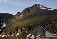
 North side of Tijeras Peak showing the Eastern break in the cliffs.
From the upper parking lot, ascend the trail approximately one mile to 11,300 foot Music Pass and its spectacular view of Tijeras Peak. Descend north along the trail into the valley of Sand Creek then ascend the valley for a ways until there is a sign and a trail branching off to the left to Lower Sand Creek Lake. Climb up this trail and its abundance of switchbacks to the shores of the lake. There are some nice camping spots just before the lake on the right.
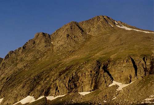
 Tijeras Peak with the Western cliff break.
Route Description
 Pico Asilado. The route crosses Deadman Creek, climbs up the stepped valley with the classic saddle beyond then turns right towards the summit. Crestone Peak rises beyond and a bit right of the ascent valley.
 The route descends from Tijeras Peak, right past the snowpatch, then back left to the head of the cirque. From here it continues past the patch of trees to the photo location.
 The route climbs up vegetated slopes towards the snow patch, continuing to the right of this in the direction of the summit.
This route could be used as a descent route for parties who made an ascent of the North-East Face, and in this way an ascent of Milwaukee Peak, Pico Asilado, and Tijeras Peak could be made in a single day. One word of caution, though - the breaks in the cliff on Tijeras Peak are difficult to see from above and might be hard to find by parties who had not ascended them. The eastern break is marked by a couple cairns on a slight prominence at the very edge of the cliff. Once at the northernmost cairn, descend on the left (western) side of this small prominence. It looks improbable from above, but after about thirty feet climb up and west over a fin of rock into the steep descent gully. There was a fixed rope here in the summer of 2009.
For added fun, it is not that far out of the way to continue down the south-west ridge of Pico Asilado, across the 12,660 foot saddle and up a short but steep climb to the summit of Peak 13,020.
For even more fun, the beautiful south-west ridge of Music Mountain could be climbed on the return trip from the clump of trees mentioned at the junction of valleys. I'd intended this but opted against it when bad weather moved in... Be aware that the East Ridge of Music Mountain is very steep and exposed, but this would make for a very nice finish to the day.
Essential Gear
This would be an extremely long day from the trailhead, so camping gear will be needed for most people to camp near the shores of Lower Sand Creek Lake. Once on the climb, standard hiking gear is recommended. Both breaks in the cliff of Tijeras Peak are north facing, so bringing an ice axe and crampons would be a good idea.External Links
 View of Tijeras Peak from the summit of Pico Asilado.