
|
|
Route |
|---|---|
|
|
37.94440°N / 105.5584°W |
|
|
scramble |
|
|
One to two days |
|
|
easy class 3 |
|
|
Approach
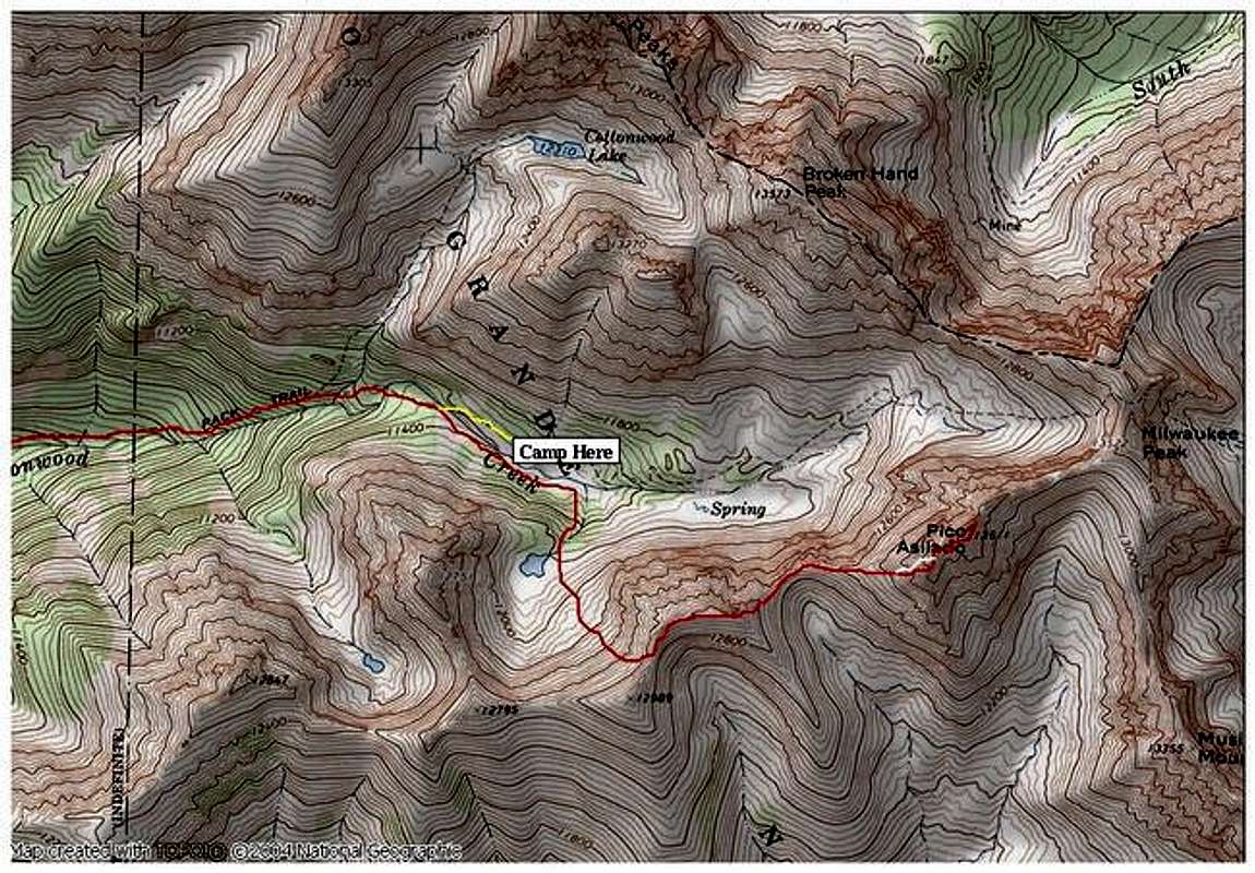
West Face of Pico Asilado
RT=11.5 miles and 5,600-ft
First, Pico Asilado makes for good early season option if the Central Sangres look to be melting fast. The entire route from the unnamed lake at 11,800-ft has southerly and west facing aspects. Furthermore, the wide gully that ascends to the summit is wide enough for the sun to reach.
From the 8,400-ft Cottonwood Creek Trailhead, hike the good trail 3.4 miles and 2,000-ft. There are a few good places to set up a camp along this forested trail. Cottonwood Creek is a present water source the entire approach.
At 3.4 miles, the faint trail will split. This spot is not easy to locate so look for a small cairns and be aware of your location by using landmarks and a topo map/GPS. The left fork will go the direction of Cottonwood Lake, the home of the Crestones. The right fork will continue up the Cottonwood Creek Drainage toward Pico Asilado. This is also the spot of a few confusing creek crossings. All I can say is look sharp for a doable creek crossing with the aid of some tiny cairns on the other side of the creek. Across the creek the trail is better, but still faint. At 11,375-ft the topo shows the trail cross the creek to the north side, we didn’t locate this crossing and wondered how the trail could have crossed back over due to the gorge-like conditions. So, stay on the south side of the creek and continue another .26 mile until you come to some open meadows, there are some good camping spots here.
Route Description
Next, locate the impressive Point 12,751 to the right (south) and the higher basin to the east of it. Locating this basin is key and should be fairly easy to locate with the aid of a topo map. There is a small stream that descends this slope and a very faint trail just to the right of it. Locate and ascend the trail about 400 vertical feet through the trees and continue to a picturesque, emerald green unnamed lake. This is a special place that doesn’t get too many visitors.
The next objective is to gain the ridge in between the unranked Point 12,989 and the ranked UN13,020 B- not marked on the USGS, Crestone Quadrangle; the slope angle here reaches about 50 degrees and consists of loose talus with some much appreciated grassy ledges. From the lake to the ridge crest between the two mentioned points is class 2+ and 1000 vertical feet. There are some steeper grassy ledges on the left side of this slope that help negotiate the unstable slope.
From this spot, verify your weather for the next few hours to be stable; the escape routes on this ridge are not good. Begin an easy class 2 stroll on a stable talus ridge to UN13,020 B. The view of the remainder of the route to Pico from this summit is good. Descend 360 vertical feet to a saddle between UN13,020 B and Pico.
From the saddle, you can easily preview the wide, talus-ridden gulley that breaks up Pico’s intricate west face. This gully is only class 2+ and provides an easy ride up through all of the towers of rock that protect Pico’s summit area. The ridge on the left side of this gully consists of steep, solid and exposed class 3 and 4 climbing. It is a tougher, more fulfilling alternative to the uncharacteristically loose west gully.
From the saddle, select your route up to the summit area of Pico Asilado. From the top of the gully, scramble another 100 yards on a solid class 2+ ridge to the summit. From here you can easily preview the ridge that connects your summit to Milwaukee Peak.
On you’re descent, retrace your steps, there are no alternatives.
Essential Gear
DEET, Ice Axe in Spring. TOPO
Miscellaneous Info
If you have information about this route that doesn't pertain to any of the other sections, please add it here.