Trip participants were Mark Patterson (my brother), Angie Patterson (his wife), Kimberly Patterson (my wife), and myself.
I had originally planned to climb something in the Andes, but my wife said we should wait until she could go with me (next year, since she is nursing). Since my brother has only been out of the USA when he lived in Micronesia, and his wife had never been out of the USA, we decided to invite them along and provide their ticket. Pico Duarte was chosen as the destination because it should be fairly challenging, but not technical at all, and far enough away from home to be a "
semi-exotic" trip. This would be Angie's first mountain, and my brother also hadn't climbed a mountain for a very long time.
December 1:
We flew into Santo Domingo and spent the rest of the day getting to Jarabacoa by bus. Since the Dominican Republic's national park service requires climbers/trekkers to have a guide to climb the peak, we found one in Jarabacoa. We ask the guide to take us on a lesser-used route through the Valle de Tetero, and arranged everything that evening. All guides (you are not allowed to climb without a guide) insist that you also hire mules for the trip, to carry all the gear.
December 2:
The next morning, at 5am, all four of us, plus the guide and all our gear, piled into an old, small, and crowded Toyota Corolla bound for La Cienaga. The road is washed out and very rough, and it was amazing that the car made it there. We had to get out and walk several sections to avoid bottoming out. At La Cienaga, we met our mules and mule wranglers, before starting up the mountain. The first part of the trail is a very gentle and pleasant walk. There were many wild citrus fruit trees along the way which offer a treat, and it was a nice walk through the forest and along the river to Casa Tablones. After Casa Tablones, the route steepens. The trail climbs steeply along the ridge all the way to the little valley at the base of Rucilla. It was 12 miles (19.5 kms) to this point. There is a cabin in the valley, but we chose to pitch a tent after hearing rumors that the cabin attracts rats. I hate rats and insisted that a tent be carried. The weather was completely clear and there were a million stars out. There were also the faint sounds of frogs croaking.
![View from summit. This is...]()
![View from near the summit. La...]()
![View from summit. This is...]()
![View from summit. This is...]()
![View from summit.]()
![View from summit. This is...]()
![Looking down on the clouds...]()
:
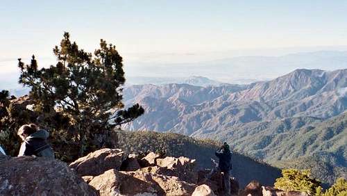
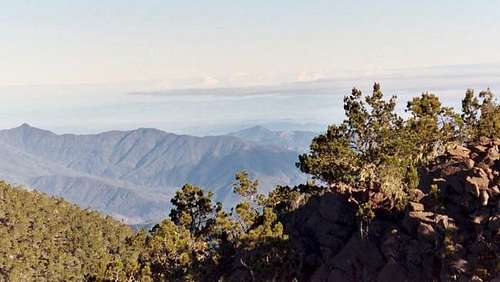
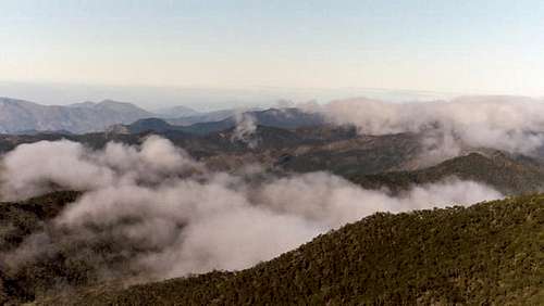
Summit day. The temperature was 35F (2C) when we awoke at 5am, and shortly thereafter, left for the summit. The trail was pretty steep and it was dark, but the required guides knew the way. Not too long before the summit, we witnessed a beautiful sunrise. The route up is just a trail, but the top pitch had some minor class-2 scrambling to liven things up. The skies were completely clear above, but there were a few cloud banks hanging on the lower slopes of the mountain. Even so, the views were incredible and we could see all the way to the ocean. After enjoying the summit, we went back to camp and packed everything back up. We then took the main trail down to Agua Fria, and then took the very steep and seldom used trail to Valle de Tetero. It is very surprising that mules could walk (slide) down that steep of trail. The valley is a very beautiful place, and there were countless colorful parrots flying overhead. The valley is a green grassy meadow with wild horses, two rivers, waterfalls, and surrounded by lush forest. Paradise. This time we decided to sleep in the cabin because it looked new and clean. It was amazing that there is a cabin here, since the valley route is seldom visited.
![Along the Valle de Tetero...]()
![Valle de Tetero. This is...]()
:
Sleepless night. We should have put up the tent. In the middle of the night, we had a visit by a rat. After chasing it away, it didn't return, but it still kept me up the rest of the night because I was wondering if it was around. I hate rats. The morning was 31F (-1C) and there was frost all around. I guess the cold air sinks down into this valley, because it is only at about 5,000 feet (1500 meters), and you wouldn't think it would freeze here in the tropics at that low of an elevation. The day was spent visiting the waterfalls for an ice cold dip and swimming, and then looking around the valley for ancient Taino petroglyphs. We found several. Our guide didn't know where they were, so we had to go looking for them. They were rather fascinating and much different from the ones you might find in the western USA. We spied many parrots as well.
December 5:
After a peaceful night, we packed up camp and hiked up the steep ridge to join the La Cienaga trail. The forest was fascinating and covered in many blooming flowers. There were a few stream crossings to liven things up before reaching the ridge-top. After that, it was just hiking down the steep trail to Casa Tablones, then along the gentle trail to La Cienaga. It was a nice hike and a great trip.


Comments
Post a Comment