Overview
Pine Mountain lies in Big Basin State Park, in the heart of the Santa Cruz Mountains. It is the second highest peak in the park, after
Eagle Rock, which lies 2 miles east. Since an unmaintained trail leads to the summit, it is rarely visited, even though many people hike within 1/4 mile of the summit. The maintained trail ends at
Buzzard's Roost, a large rock outcropping northeast of the summit. See section below for more information on Buzzard's Roost. There are more rock outcroppings east of Pine Mountain, near an abandoned radio site. The rocks host better views than the summit itself, yet peakbaggers will want to visit the summit. Pine Mountain is covered in, as you may have guessed, pine trees. The flora is very similar to that of the Sierra Nevada, and this sticks out in a sea of redwood trees that is the Santa Cruz Mountains. The summit is very flat, yet the sides steepen as you descend. A rock cairn marks the summit, yet we couldn't find any USGS marker. Views from the vicinity stretch endlessly over the Santa Cruz Mountains and south towards the Santa Lucia Range across the Monterey Bay.
Getting There
The trailhead for Pine Mountain is located at the Big Basin State Park Headquarters along Highway 236. About an hour's drive from the San Jose area, travel south on Highway 17 into Los Gatos. Take the Highway 9 Monte Sereno exit, and head towards Saratoga on 9. Once in downtown Saratoga, 9 will turn left and go into the mountains. Stay on 9 when you come to the junction of Highway 35. Enter Santa Cruz county and continue. Take Highway 236 when it veers off of 9. Follow this one lane road for about 10 miles to the park headquarters. Click here for the Big Basin
Trail Map. Follow the directions on the
Pine Mountain Trail Route Page to the summit.
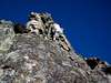
Buzzard's Roost
Buzzard's Roost is a large sandstone outcropping northeast of the summit. There are many routes on the east side that rate class 3-4. These can be pretty hairy without ropes, so be prepared and climb under your own comfort level. There is another large sandstone rock outcropping east of Pine Mouantin, next to a radio site. A small trail leads east from Buzzard's Roost to the radio site. There are quite a few class 4-5 routes here as well.
Red Tape
There are no permits needed to climb Pine Mountain, however, parking costs six dollars at the park headquarters.
When To Climb
Pine Mountain can be climbed any time of the year. The rocks at Buzzard's Roost can be quite slippery after a rainstorm, as could Pine Mountain Trail. Summer temperatures are mild, seeing that 95% of the hike is under canopy. The current weather in Boulder Creek:

Camping
There are three campgrounds at park headquarters: Jay, Blooms Creek, and Sempervirens Campgrounds. Check out the Big Basin
camping page for more info.
Mountain Conditions
Pine Mountain Trail can be very muddy after a rainstorm. Check for trail conditions at the Big Basin
trail page.
External Links

 19152 Hits
 90.13% Score
 31 Votes


SSPPOEB - Jun 28, 2013 1:03 pm - Hasn't voted
A few details...Hi, as the supervising ranger for the park, I just wanted to make a few corrections. While bouldering is perfectly acceptable, we do not allow placement of any ropes or anchors. Parking costs $10, and please note there is no day-use parking at Little Basin. Enjoy our beautiful park!!