
|
|
Route |
|---|---|
|
|
46.41503°N / 9.88588°E |
|
|
Mountaineering |
|
|
Summer |
|
|
Most of a day |
|
|
F+ (Alpine scale) |
|
|
Overview
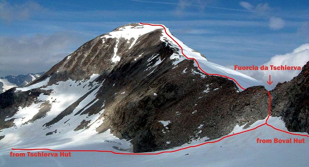
Piz Tschierva crossing
Piz Tschierva is an imposing and harmonious mountain, dominating the Eastern side of the Val Roseg, although it appears a little bit into the background because of the proximity of the mighty Piz Morteratsch, one of the giants of the Bernina group. It's a scenic spot of great interest and has three sides, separated by as many ridges. Will be described a long but wonderful and satisfactory crossing, climbing in its ending section the East Ridge, which is the route of the first summiters of the peak, Johann Coaz and companions, August 18, 1850.

This route can be climbed either starting from Tschierva Hütte in Val Roseg or from Boval Hütte on the Morteratsch glacier, in my opinion the best way is rising from the Morteratsch side and descending to the Tschierva side. The final section of the route, starting from Fuorcla Tschierva, is an easy and panoramic crest facing East.

|

|
Getting There
The starting point to reach the Boval Hut is Morteratsch, a little settlement at 1896 m. of altitude located along the Retic Railway. The starting point to reach the Tschierva Hut is the village of Pontresina. Both Morteratsch and Pontresina are located on the road running from S. Moritz to the Bernina Pass.
From Italy
From Milano reach Lecco, then follow the road 36 along Lago di Como to Colico; here turn to right taking the Valtellina road to Sondrio and Tirano. Here leave the Valtellina road and turn to right, entering in Switzwerland , reaching Poschiavo, Bernina Pass and Morteratsch. An alternative access is via Chiavenna, Maloia Pass, Silvaplana, St. Moritz, Pontresina and Morteratsch.
From Switzerland
The nearest resort is the town of St. Moritz.
Route description
Piz Tschierva East Ridge from Boval Hütte
Difficulty: F+ (Alpine) - II grade (rocky section)
Difference in level: 1050 m from the shelter
A pleasant climb, a lot of fun on the rocks and the easy summit ridge! The view from the top is wonderful over some major peaks of Bernina group, as Piz Morteratsch and Piz Roseg.
From the large parking in Morteratsch (a fee is due) follow the road which soon leads to the small station of the Bernina train. Just beyond, take the path that branches off almost immediately, leave out the left branch that leads to the glacier and follow the one on the right, with directions to the by Boval Hütte. The well worn path enters the forest, climbs steeply towards the SW, then goes gently sloping to the right of the moraine of the Morteratsch glacier. After a short fixed rope the path reach the shelter (2 hours).

|

|
Behind the hut, follow the path towards W, which rises in the direction of the Corn Boval, initially on the pastures, then on the moraine, reaching the base of south wall of the Corn Boval. At about 2800 m. of altitude We continue towards SW, in the wide snowy depression occupied by the remains of Vadret Boval Dadains. Now we follow the small glacier, heading to the rocky wall 150 m high and facing East. We get the bottom at about 3000 m. of altitude and start to climb it on rocky steps, easier at the beginning, then steeper and exposed (II grade UIAA scale) in the middle section. Follow a traverse to the left on a ledge, then on less demanding ground (I) reach the Fuorcla Boval (2.30 h from the shelter).

|

|

|
Descend easily on Vadrettin Tschierva and cross towards right in the direction of Piz Tschierva. At the end of the glacier, a steep slope of rocks and scree leads to the Fuorcla da Tschierva. From here follow the snowy gentle East ridge, reaching the summit cairn (3,15 hours from the shelter). A wonderful scenery does appear!
**Descent - Go back down the ridge of Piz Tschierva and climb, properly roped up, the easier Vadrettin Tschierva. Staying close to the orographic right side, go down the glacier to reach the moraine. Initially on track and then on the path, you reach the Tschierva Hütte. From the shelter contimue the descent, skirting the Vadret da Tschierva and then on well-marked path head towards the upper Val Roseg plains, reaching Margun Misaun m. 2245 and then come the Hotel Roseg m. 1999 m, the terminus of the horse-drawn carriages, the only means of transport, together with bicycles, which are allowed to enter the valley. The coaches must however be booked at least the day before,so if you haven't booked in time, all that remains is to walk along Val Roseg, more than 6 km, down to Pontresina, where you can take the Bernina train, or bus and return to Morteratsch.

**Ski-Mountaineering - The route is a good ski-tour in Spring, with the advertising that you have to carry your skies along the steep rocky section below Fuorcla Boval.
Essential Gear
Ice-axe, crampons, a short rope, eventually an helmet
Red Tape
No permits required. A fee is due in the Morteratsch parking. Cars are banned in Val Roseg.
Huts
Val Roseg
* Chamanna da Boval (Boval-Hütte) 2495 m - CAS Bernina Open: 15 of March - 15 of May and 15 of june - 15 of October Size: 100 persons + 12 in the winter-shelter Getting There: 2 hours by walking on a path running on the left orographical side of Morteratsch Glacier Phone: 0041-8266403
* Chamanna da Tschierva (Tschierva Hütte) 2573 m - CAS Bernina Open: end of March - 15 of May and 15 of June - 15 of October Size: 100 persons + 30 in the winter shelter Getting There: from Pontresina via the Val Roseg - 3,30 hours on path Phone: 0041-8266391

When to climb
The best season is summer (from July to September), spring for ski-mountaineering
Bibliography
* "Bernina" N. Canetta and G. Miotti - Guide dei Monti d'Italia CAI-TCI -
* "Bernina" Swisstopo 1277 - 1:25000
selinunte01 - Dec 5, 2014 6:24 am - Voted 10/10
Ski RouteI should add that both routes from Chamanna da Boval and Tschierva are rather common ski routes, too. Main season für that is February through May. Don´t forget your avalanche gear! Cheers, Michael
alpinbeta - Dec 9, 2014 3:41 pm - Hasn't voted
Re: Ski RouteHi Michael, thanks for your suggestion. The route from Chamanna Tschierva is surely a good ski route, but the route from Chamanna da Boval has a central rocky section that cannot be climbed without taking off the ski...so i'm not sure it's a good ski route. What do you think about? Cheers, Walter
selinunte01 - Dec 11, 2014 6:28 am - Voted 10/10
Re: Ski RouteHello Walter, I know that rock section above Chamanna Boval very well (in summer) and I was told that the route is done as a ski route, too. It normally is one of the main ski routes to Piz Morteratsch but you can do Piz Tschierva as well. You may have to carry your skies (as it is done on the Fortezza route to Piz Palü or Piz Bernina), but I think with a sufficient snow cover it will only be the steepest upper part (crampons and ice axa are a must). Happy climbing, Michael