Planaria

Page Type Page Type: Route
Location Lat/Lon: 37.10970°N / 118.4917°W
Additional Information Route Type: Technical Rock Climb
Additional Information Time Required: A long day
Additional Information Difficulty: V 5.10
Sign the Climber's Log

Approach

Temple Crag: Planaria
Drive east out of Big Pine to the end of Glacier Lodge Road (about 15 miles). The hiker parking is about 0.6 miles from the end of the road and the site of the former Glacier Lodge. For those who would rather cut a mile or so from their round trip, and bypass the sweltering traverse from the hiker parking to the entrance to the NF canyon, parking is available at the Glacier Lodge Store for $3 a night.

From wherever you park, follow the trail up the north fork of Big Pine Creek. The best place to camp is Third Lake (~10,260’, and about 5.5 miles from the road). If Third Lake is crowded (as it often is) or you just want to be closer to the start, it is possible to camp about ¼ mile south of Third Lake just before heading up the talus and scree towards the base of the climb. Often in early season, snow and running water can be found in the camping areas close to the climb. If it is late season or a low snow year, Third Lake is the closest water.

From Third Lake, cross the outlet stream over fallen logs at the east end of Third Lake, and follow a use trail up onto the moraine. This peters out after about 100 yards, and the rest of the way is on talus and scree. Head more or less directly south, then aim for the face below the shallow dihedral that comprises this route, which is located to the right of Barefoot Bynum and Dark Star.

Route Description

Temple Crag - Planaria
See topo.

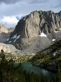
In the attached photo, Planaria is in the center -- the obvious sunlit dihedral on the Lower Buttress of Temple Crag.

The original Wiltsie/Jensen route ascended a shallow, right-facing dihedral up to a right-trending roof, thence up into the large, shallow dihedral that comprises the bulk of the route.

The free variation starts up a 5.9 crack to the right of this dihedral, then works up the face past a pin and two bolts to rejoin the aid route out to the right of the end of the afore-mentioned roof.

Higher, at the flatworm flake that gives the route its name, a choice presents itself: climb the right side of the flatworm (the route of the first ascent, about 5.9) or struggle up the offwidth crack on the left side (5.10).

Continue to the summit, following your nose.

Essential Gear

Planaria, Temple Crag

Rack:
2 KBs, 2 LAs
Stoppers and some brass
Pink, red, and brown tricams
cams from blue Alien to #4.5 Camelot
Alien Hybrids also useful.

A 55m - 60m rope is useful on some of the longer pitches. See topo.

History

In 1997, Gordon Wiltsie and Jay Jensen established Planaria, using aid to ascend a shallow, right-facing dihedral up to a right-trending roof, thence up into the large shallow dihedral that comprises the bulk of the route.

Higher, after a 60-foot fall out of the left side, Gorden and Jay went up the right side of the flatworm flake that gives the route its name.

The pair ended their fine ascent at the top of the Lower Buttress where the route joins with Dark Star and Barefoot Bynum.

Partly because of the route's reputation, and partly because freeing the first two pitches looked unlikely at best, Planaria went unrepeated for over 20 years.

The free variation established by Bob Harrington and Bruce Bindner in 1998 starts up a 5.9 crack to the right of the aid route, then works up the face past a pin and two bolts to rejoin the Wiltsie-Jensen line out to the right of the end of the right-trending aid roof.

During the all-free ascent, the left side of the flatworm flake was climbed free in the 5.10 range, the crux being 4.5" to 5.5" offwidth.

Harrington and Bindner then continued to the summit of Temple Crag, rating the entire route to the summit a Grade V.


Parents 

Parents

Parents refers to a larger category under which an object falls. For example, theAconcagua mountain page has the 'Aconcagua Group' and the 'Seven Summits' asparents and is a parent itself to many routes, photos, and Trip Reports.