Overview
If you were to hike the entire Massanutten Mountains from north to south, Point 2015 would be the first summit that you would reach. Point 2015 is found near the northern end of the main eastern Massanutten ridge. Although this peak barely clears 2,000 feet, all of the routes to its summit involve an elevation gain of about 1,300 feet. One of the routes goes over Buzzard Rock, which is a popular destination for hikers and the only established rock climbing site in the Massanuttens. Another route goes through the historic Elizabeth Furnace area and allows hikers to combine a hike to Point 2015 with a canoe trip down nearby Passage Creek.
Getting There
Buzzard Rock Trail: From Front Royal, drive west on Route 55 until reaching SR 678. Turn left onto SR 678 and follow it to SR 619. Turn left on SR 619 and follow it for 1.2 miles until the turnoff for the Buzzard Rock Trail on the right. Parking is available for about 10 cars.
Follow the white-blazed Buzzard Rock Trail up to the point where you gain the ridge. There are views available to the north here. Continue until reaching Buzzard Rock, which is 2.3 miles from the trailhead. Enjoy the views of Meneka Peak, the western ridge of the Massanutten Mountains, and Fort Valley. From Buzzard Rock, continue for 1 mile on the trail to reach the north summit (which has an elevation of 2,015 feet on the topo map) and additional 0.2 miles to reach the south summit (which is also between 2,000 and 2,020 feet).
Round trip: 7 miles with an elevation gain of 1,300 feet.
![Meneka Peak]() Meneka Peak
Meneka Peak | ![Fort Valley from Buzzard Rock]() Fort Valley
Fort Valley | ![Rock Formation at South Summit]() South Summit
South Summit |
From Front Royal, drive west on Route 55 until reaching SR 678. Turn left onto SR 678 and follow it to the Elizabeth Furnace Recreation Area. Turn left into Elizabeth Furnace Recreation Area (past group camping sign). Park will be on your left before a small bridge.
Walk across the bridge and then make an immediate left onto the Massanutten and Tusacarora Trails, which are blazed orange and blue. After about 0.1 miles, reach Elizabeth Furnace. Turn right here onto an unblazed trail. Make the first left after the "Trail's End" sign, and then another left at the "Passage Creek Forest Trail" sign. At the "When Pig Iron Was King" sign, make a right. Follow this trail past the old colliers hut and wagon axle. Just after the old mine entrance, make a left onto an old wagon road, upon which you will make a steep ascent of 0.9 miles to the crest of the ridge.
Here, you will make a left onto Massanutten and Tusacarora Trails and reach Shawl Gap. Continue straight on the Buzzard Rock Trail for 0.4 miles to the south summit and an additional 0.2 miles to the north summit.
Round trip: 3.6 miles with an elevation gain of 1,300 feet.
If you have a full day, it is possible to combine this hike with a canoe trip down Passage Creek. There are sites in the Elizabeth Furnace Recreation Area where you can put your canoe into the creek. It is about 6 miles downstream to where you take your canoe out; rapids tend to be Class II and Class III.
![Old Colliers Hut]() Old Colliers Hut
Old Colliers Hut |
![Old Wagon Axle]() Old Wagon Axle
Old Wagon Axle |
![Old Iron Ore Mine]() Old Mine
Old Mine |
From Front Royal, drive west on Route 55 until reaching SR 678. Turn left onto SR 678 and follow it to SR 619. Turn left on SR 619 and continue to SR 613. Turn right on SR 613 and follow it for 1.5 miles until the turnoff for the Shawl Gap Trail on the right. Park here and dismount your vehicle.
Hike up the yellow-blazed Shawl Gap Trail for 2.1 miles until reaching Shawl Gap. Turn right on the Buzzard Rock Trail and follow it for 0.4 miles to the south summit and an additional 0.2 miles to the north summit.
Round trip: 5.4 miles with an elevation gain of 1,300 feet.
Red Tape
Point 2015 and the entire route to its summit are on public land in the George Washington National Forest. There are no fees or permits required for hiking or camping except at Elizabeth Furnace. On the Buzzard Rock Trail, there are some places before you gain the ridge where there is private property nearby. Please don’t wander very far off the trail here.
Camping
Free camping is permitted throughout the George Washington National Forest except in the immediate vicinity of picnic areas and a few other locations. Elizabeth Furnace Recreation Area has a large campsite with restrooms and picnic areas. The fee is $10 per night; contact the Lee Ranger District for further information.
There are good campsites at Shawl Gap near the intersection of the Point 2015, Massanutten, Tuscarora, and Shawl Gap Trails, and on the west side of the Buzzard Rock Trail near the south summit. Other campsites are near the Buzzard Rock Trail between Buzzard Rock and the north summit.
When to Climb
Point 2015 can be climbed nearly all year round. The hike can be particularly delightful from mid-October through mid-November because of the autumn colors. Winter hikes can also be pleasant, especially when the trails are blanked in a few inches of snow. July and August are the worst months for heat, humidity, haze that limits views, and hostile little critters like ticks, yellowjackets, and mosquitoes. The best time for a summer hike is early in the morning.
Hiking should be avoided in the National Forest during the period in late November when it is permissible to hunt deer with modern firearms. In 2019, deer season runs from November 16 through November 30.
![Elizabeth Furnace in Winter]() Elizabeth Furnace in Winter
Elizabeth Furnace in Winter![Passage Creek in Winter]() Passage Creek in Winter
Passage Creek in WinterExternal Links
George Washington National Forest- Lee Ranger District
The
Potomac Appalachian Trail Club maintains the trails in the Massanutten Mountains, and provides maps, guidebooks, and other information.
American Whitewater offers some more details about canoeing Passage Creek.
rockclimbing.com offers some more details about Class 5 climbing at Buzzard Rocks.

 4607 Hits
 82.48% Score
 15 Votes
 Meneka Peak
 Fort Valley
 South Summit
 Old Colliers Hut
 Old Wagon Axle
 Old Mine
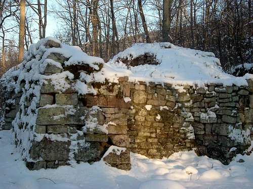 Elizabeth Furnace in Winter
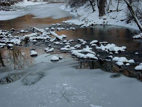 Passage Creek in Winter