
|
|
Route |
|---|---|
|
|
40.77380°N / 110.7521°W |
|
|
Scramble |
|
|
A few days |
|
|
Class 2-3 |
|
|
Approach
First you must drive Highway 150 south from Evanston Wyoming, or east and then north from Kamas Utah. The North Slope (gravel) road heads east from Highway 150 either just south of the Bear River Lodge, or two miles north of the Bear River Visitor Center. After following the North Slope Road for two miles, turn right and follow the main road all the way (don’t turn into the scout camp) to the trailhead. The road is usually a washboard, but any car should be able to make it.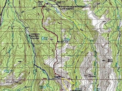 The Yellow Route is the Priord Lake Route up Lamotte Peak.
Route Description
From the trailhead at 9150 feet elevation, follow the East Fork Bear River Trail east. There is a 4-way trail junction just after the trailhead, but go straight (the trail that crosses this one is the Bear River-Smiths Fork Trail. The trail drops down to the river at 8900 feet elevation, and after a few miles of following the trail along the river, the trail reaches a meadow with some very old “tie hack” cabins. These cabins were built during the 1860’s in order to cut timber for railroad ties for the Cross-Continental Railroad.Continue following the trail along the river at a gentle grade. After 4 miles, you will reach a trail junction. Turn right here on the trail posted for Priord Lake. Follow the trail across the good bridge and along the river up to Norice Lake, which is 4.75 miles from the junction and at 10,450 feet elevation. The trail is not used heavily and last time I was there, I had to route-find after loosing the trail in places (early 1990’s). There are a few stream crossings and the trail is not exactly where the topo maps (Red Knob) show it. Don’t be surprised if the trail is on the opposite side of the trail than the map shows it at.
Priord Lake is another mile up the bench to the SW. The trail is very faded, but cross-country travel is easy. Both Norice and Priord Lakes are in beautiful alpine meadows right near the timberline, and surrounded by cliffs. Either makes an ideal base camp for the climb of Lamotte Peak.
From Priord Lake, head NW to and up the very steep ridge to the ridge. There is much boulder-hopping and it’s steep, but there are no major problems. One on the ridge simply follow it north to the summit. The summit is about 2 miles from Priord Lake. There are spectacular views of countless surrounding peaks. Although Lamotte Peak is the highest peak in the immediate area, all the surrounding peaks are more rugged.
 Priord Lake and Lamotte Peak.