
-
 8214 Hits
-
 77.48% Score
-
 8 Votes
|
|
Route |
|---|---|
|
|
40.81381°N / 110.76553°W |
|
|
Skiing |
|
|
A long day |
|
|
Class 2-3 |
|
|
Overview
Winter variation of the North Ridge route, using a lower-elevation ski trailhead and less steep route to the treeline than the standart Baker Lake variation.Getting There
Bear River Winter TH is South of Evanston, WY on SR 150. The highway is gated beyond the trailhead.Route Description
 Yurt Trail
Bear River Winter TH, at 8,350, is the next-best winter access point for High Uintas after Henry's Fk TH. The area is a major snowmobilers' paradise but a 'bile-free corridor out of the NE corner of the parking lot leads across a skier / hiker bridge across East Fork Bear River and into miles of groomed trails, courtesy of Bear River Outdoor Recreation Association, most of which are strictly non-motorized as well.
 Bearclaw Yurt
Any named mountains are still pretty far out in this direction. Lamotte, 10 to 11 airline miles away, is the closest. So it is really helpful that BRORA also supports 4 inexpensive yurts, located between a mile and four and a half miles from the TH (red dots on the topo). Booking a yurt allows one an early start, and potentially a shorter return distance if the second night is also reserved.
 Route map
The Southern-most loop of the BRORA groomed ski trail system is on Ridgeline Trail, near 9,350 ft elevation. A jeep road continues SSE along the East side of the Hill 9,501. In less than 200 yards, look for an ATV track branching off to the right and uphill (shown by red streaks on this aerial shot). It follows the East side of the crest, connecting with Bear River - Smith Fk trail in a burnt-out forest area. The trail descends sharply to the flats to the SE, where it connects with generously tape-blazed Boundary Creek trail (orange tape on trees). The junction is in about 5.5 miles from Bear River winter trailhead.
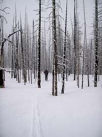 Burnt Forest
In just over a half-mile, the trail crosses the creek, and it's an easy going along the meadows of its East bank. One can arguably avoid somes ups and downs of this route by traversing high on the West side towards Scow Lake, but in most conditions, the meadows stretch of Boundary Creek valley is hard to resist.
Then Boundary Creek begins to round the corner of Hill 10,859 and turn South-East. It's time to get out of this drainage and head due South towards Scow Lake, nearly a mile away. There are multiple gullies going in this direction; the main drainage will likely be on you right (West), but one would be just fine staying a bit East of the lake as well.
 Scow Lake Ridge
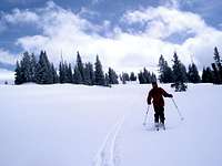
Past the lake, it's time to turn South-East and gradually gain about 900 ft towards the tree line through the open woods of a major gully-bench. (A variation, partly tested on our April 15th tour, might be to contour South at 10,500 ft elevation into the bowl, and ascend the spur ridge on the bowl's West side).
 At the tree line
From the tree line on a spur ridge, a long upward traverse to the right brings the skiers to the Saddle 11,700. With nearly absent visibility on our ascent, we kept too close to the ridgeline, where wind-exposed rocks hamper skiing. On the way back, it turned that uninterrupted snowfields stretched just a bit further below the ridge on the North.
 Rock outcropping East of Saddle 11,700
 The ridge turns SSE past Hill 11,783
South of Hill 11,783, the ridge narrows and undulates through several humps, the second of which had a rocky South side and needed to be booted. The skis remain useful on the following segment of the ridge, but beyong 12,300 ft, the ridge is all rocky on the right, and cornicy on the left, and it's the best booted.
 The narrow section of the ridge The narrow section of the ridge | 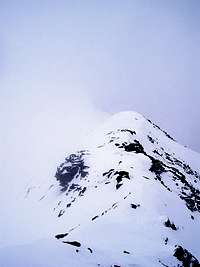 First two humps are skiable First two humps are skiable |  Upper North Ridge Upper North Ridge |  View East to Stillwater Fork View East to Stillwater Fork |
 On the ridge in a whiteout On the ridge in a whiteout |  View to Ostler Lake View to Ostler Lake |  View West to the Cathedral View West to the Cathedral |  Lamotte from the TH area Lamotte from the TH area |
Essential Gear
Skiing gear. Climbing skins and transcievers highly suggested.External Links
BRORA trail map: