
-
 19665 Hits
-
 73.06% Score
-
 3 Votes
|
|
Route |
|---|---|
|
|
42.86130°N / 72.1083°W |
|
|
Hike |
|
|
Half a day |
|
|
Walk-up |
|
|
Approach
See the Getting There section of the main page to get to the trailhead.
Route Description
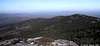
The trail starts out as a wide one and soon passes through an old stone wall which was an old property marker. A stone wall then runs along the left side of the trail for a ways. When the trail starts to ascend, watch for a viewpoint off to the left side of the trail for some views if it's clear.
The trail climbs to a rock ridge, the Dublin Ridge, and goes along it's spine gently going up about 3 small spines in the ridge which are a bit more bare than the surroundings and good spots for snacks or a lunch. The true summit is seen to the right of the ridge just to the west of the false summit. The first junction you come to is the Cascade Link and then the Spellman Trail. Just after the Spellman Trail intersection, you will come to a arge rectangular rock called the Sarcophagus for obvious reasons.
You'll then pass the Red Spot/Old Ski Trail and the trees thin. From here, follow the cairns. There is a small dip in the trail to scramble before the final climb on bare rock to the summit.
To return, look for a painted Pumpelly Trail sign on the bare rock with an arrow. It's easy to get off on the wrong trail from the summit as most hikers go down one of the other trails.
The trail is named for a local conservationist who marked it out in 1884. It's about 9 miles round trip with 2670 feet of elevation gain. Takes about 5 to 7 hours round trip.
 |
Essential Gear
None needed except for proper clothing and food/water.