


-
 3506 Hits
-
 78.27% Score
-
 9 Votes
|
|
Route |
|---|---|
|
|
45.47548°N / 7.11483°E |
|
|
Mountaineering |
|
|
Summer, Fall |
|
|
A long day |
|
|
F+/PD- |
|
|
II |
|
|
Note
|
La montagna chiama i suoi figli, ed essi rispondono fedelmente al suo appello… Osvaldo Cardellina, Diario alpinistico, 1964-65 Page texts: @ OsvaldoCardellina "Osva", passed away on May 2, 2022. Page owners: Christian Cardellina e Osvaldo Cardellina. Any updates from September 12, 2022: Antonio Giani, page administrator, friend and climbing companion. Testi della pagina: @ OsvaldoCardellina "Osva", scomparso il 2 maggio 2022. Proprietari pagina: Christian Cardellina e Osvaldo Cardellina. Eventuali aggiornamenti dal 12 settembre 2022: Antonio Giani, amministratore della pagina, amico e compagno di salite. |
Basis Overview Plinth
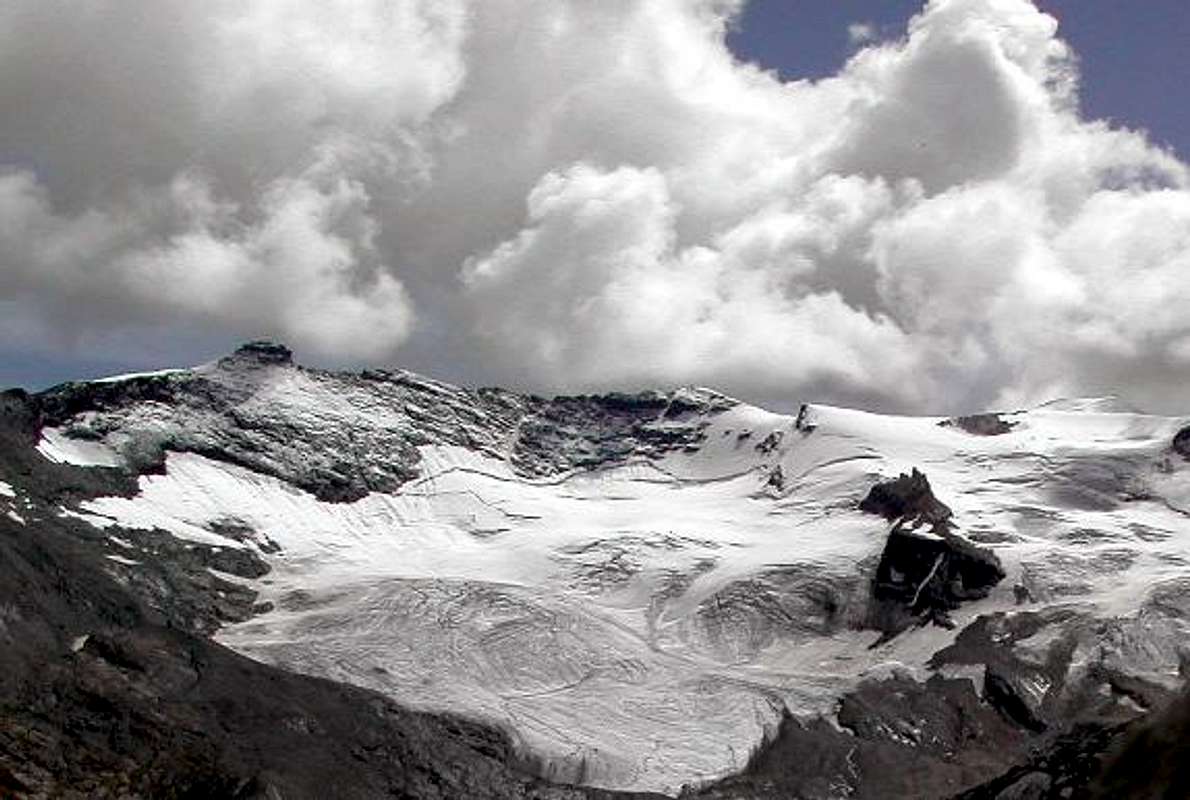
Important Summit (3.338 m), sited at the end on middle part of the watershed between the Valleys Savara Rhêmes and before its conclusion with Punta Galisia.
By the latter (3.346m), located in the triple border with Piedmont and France, it goes down towards the North a long buttress that ends with the Subgroup of Punta Bioula over the course of Dora Baltea, near the Commons of Villeneuve, Introd and Rhêmes St. Georges. Between the two is inserted the less evident Punta Bousson (3.337m) that "binds" to the Galisia with Glacier Oriental de Fond and to the Basei on the Glacier de Lavassey. This is therefore the shape of Western side of the three mountains, while on the opposite side of the same "melt" together into one big cliff/wall overlooking the final part of the Plan of Nivolé or Nivolet and the terminal of Ceresole Valley, also called Locana, Soana or generically of Orco by the name of river that runs through it. The next Col de Basei (3.176m) marks the only transit point between the two valleys, and after the same, the watershed configures a number of less important Summit (Nivoletta, Vaudala, Rosset, Leynir) until you reach the Subgroup of Taou or Tout Blanc, Aouille and Entrelor (3.438m, 3.445m, 3.430m), all located above the Thumel Villages (1.879 meters to the West) and Pont Valsavarenche. On both sides rise paths that reach this important hill through easy terrain and evident in the medium to low-lying areas and moraines and rocks in those terminals, the latter crossed by some traits not always comfortable to deal with. Final part instead becomes common with the ascent of the North Ridge easy, at the end of which, however, there is a rocky turret exposed but already equipped with some nails (I°+/II°-).
![]()
Nearby the Basei Summit towards the Punta Tsanteleina & Grande Sassière, by Marco Cossard 1980
By the latter (3.346m), located in the triple border with Piedmont and France, it goes down towards the North a long buttress that ends with the Subgroup of Punta Bioula over the course of Dora Baltea, near the Commons of Villeneuve, Introd and Rhêmes St. Georges. Between the two is inserted the less evident Punta Bousson (3.337m) that "binds" to the Galisia with Glacier Oriental de Fond and to the Basei on the Glacier de Lavassey. This is therefore the shape of Western side of the three mountains, while on the opposite side of the same "melt" together into one big cliff/wall overlooking the final part of the Plan of Nivolé or Nivolet and the terminal of Ceresole Valley, also called Locana, Soana or generically of Orco by the name of river that runs through it. The next Col de Basei (3.176m) marks the only transit point between the two valleys, and after the same, the watershed configures a number of less important Summit (Nivoletta, Vaudala, Rosset, Leynir) until you reach the Subgroup of Taou or Tout Blanc, Aouille and Entrelor (3.438m, 3.445m, 3.430m), all located above the Thumel Villages (1.879 meters to the West) and Pont Valsavarenche. On both sides rise paths that reach this important hill through easy terrain and evident in the medium to low-lying areas and moraines and rocks in those terminals, the latter crossed by some traits not always comfortable to deal with. Final part instead becomes common with the ascent of the North Ridge easy, at the end of which, however, there is a rocky turret exposed but already equipped with some nails (I°+/II°-).
Importante Vetta (3.338 m) collocata al termine della parte media sullo spartiacque tra le Valli Savara e Rhêmes e prima della sua conclusione con Punta Galisia.
Da quest'ultima (3.346 m), posta al triplice confine con il Piemonte e la Francia, scende infatti verso Settentrione quel lungo contrafforte che si conclude con il Sottogruppo della Punta Bioula sopra il corso della Dora Baltea, presso i Comuni di Villeneuve, Introd e Rhêmes St. Georges. Tra le due é inserita la meno evidente Punta Bousson (3.337 m) che si "lega" alla Galisia con il Glacier Oriental de Fond ed alla Basei con il Glacier de Lavassey. Questa risulta quindi la conformazione Occidentale delle tre montagne, mentre sul lato opposto le stesse si "fondono" in un'unica grande parete rocciosa che sovrasta la parte finale del Pianoro del Nivolè o Nivolet e quella terminale della Valle di Ceresole, detta anche di Locana, Soana o genericamente dell'Orco per il fiume percorrentela. Il successivo Colle di Basei (3.176 m) segna l'unico punto di transito tra le due vallate, mentre, dopo il medesimo, lo spartiacque configura una serie di Sommità meno importanti (Nivoletta, Vaudala, Rosset, Leynir) fino a raggiungere il Sottogruppo di Taou o Tout Blanc, Aouillé ed Entrelor (3.438 m, 3.445 m, 3.430 m), posto sopra i Villaggi di Thumel (1.879 metri ad Ovest) e Pont Valsavarenche. D'ambo i lati salgono sentieri raggiungenti questo importante colle tramite percorsi facili ed evidenti nelle parti medio-basse e con morene e pietraie in quelle terminali, quest'ultime attraversate da alcuni tratti non sempre comodi da affrontare. La parte finale invece diviene comune con la salita della facile Cresta Nord, al termine della quale esiste però una torretta rocciosa esposta ma già attrezzata (I°+/II°-).
Da quest'ultima (3.346 m), posta al triplice confine con il Piemonte e la Francia, scende infatti verso Settentrione quel lungo contrafforte che si conclude con il Sottogruppo della Punta Bioula sopra il corso della Dora Baltea, presso i Comuni di Villeneuve, Introd e Rhêmes St. Georges. Tra le due é inserita la meno evidente Punta Bousson (3.337 m) che si "lega" alla Galisia con il Glacier Oriental de Fond ed alla Basei con il Glacier de Lavassey. Questa risulta quindi la conformazione Occidentale delle tre montagne, mentre sul lato opposto le stesse si "fondono" in un'unica grande parete rocciosa che sovrasta la parte finale del Pianoro del Nivolè o Nivolet e quella terminale della Valle di Ceresole, detta anche di Locana, Soana o genericamente dell'Orco per il fiume percorrentela. Il successivo Colle di Basei (3.176 m) segna l'unico punto di transito tra le due vallate, mentre, dopo il medesimo, lo spartiacque configura una serie di Sommità meno importanti (Nivoletta, Vaudala, Rosset, Leynir) fino a raggiungere il Sottogruppo di Taou o Tout Blanc, Aouillé ed Entrelor (3.438 m, 3.445 m, 3.430 m), posto sopra i Villaggi di Thumel (1.879 metri ad Ovest) e Pont Valsavarenche. D'ambo i lati salgono sentieri raggiungenti questo importante colle tramite percorsi facili ed evidenti nelle parti medio-basse e con morene e pietraie in quelle terminali, quest'ultime attraversate da alcuni tratti non sempre comodi da affrontare. La parte finale invece diviene comune con la salita della facile Cresta Nord, al termine della quale esiste però una torretta rocciosa esposta ma già attrezzata (I°+/II°-).
First Ascents
- First known on the Summit: Camillo Poccardi and Giovanni Blanchetti; August, 1875, in ascent from Nivolé through Basei's Glacier.
- First in Winter: unknown.
- North Crest (Normal Via): Giovanni Bobba with Rhêmes Mountain Guide Casimire Thèrisod; August 17th, 1888.
- Southeast Spur of Northeast Antesummit: Massimo Mila and Leo Ravelli; July 30th, 1956, in ascent from Nivolé Tableland.
- Southastern Slope: Giovanni Bobba with Rhêmes Mountain Guide Casimire Thèrisod; August 08th, 1889.
- Southeast Wall (Second Spur): Enrico Marta and Giorgio Viale; August 05th, 1970, in ascent from Nivolé Tableland.
- Southwest Ridge: Giovanni Bobba with Rhêmes Mountain Guide Casimire Thèrisod; August 08th, 1889, in traverse from Punta Bousson.
- West Face: Nini Daga Demaria, lone; August 21th, 1961, in ascent from Lavassey Glacier; In descent: Osvaldo Cardellina and Giuseppe Lamazzi; July 21th, 1974.
- Great Crossing (P. di Lavassey - P. di Paletta North and South - Gran Vaudala North and South - Cime di Nivoletta North and South - P. Basei Western Wall, in descent - P. Bousson - North-northwestern Face in ascent): Osvaldo Cardellina and Giuseppe Lamazzi; July 21th, 1974, in day from Thumel Village.
- Great Crossing S/N: (Punta Basei - Cime di Nivoletta South and North - Gran Vaudala South and North - Punta del Rosset - Punte del Leynir South and North - Punta Celestino Bess): Osvaldo Cardellina, Marco Cossard, Camillo Roberto Ferronato, Giuseppe Lamazzi, Nino Trapani and Nino Sandretto (until Punta Rosset); July 28th, 1974.
Getting There
BY CAR:
BY PLANE:
- From TORINO, MILANO, etc: Motorway A5. Exit at IVREA or Quincinetto (PIEDMONT) also Pont Saint Martin, Verrès, Chatillon, AOSTA East (Nus) and West (Aymavilles) Municipalities (AOSTA Valley).
- From IVREA Town to Aymavilles, Villeneuve Municipalities.
- From Aymavilles to Villeneuve and from this to Valsavarenche or directly by Villeneuve
- From Aymavilles (646m) towards Villeneuve (670m) through Regional Road in South of Dora Baltea.
- From Villeneuve to Savarenche Valley, Dégioz-Valsavarenche (1.541m) up to the Pont Valsavarenche (1.946m). Albergo Savoia and Città di Chivasso Refuges at the end of Nivolé Tableland below the homonym Hill and Punta Basei, through muletracks.
- From Villeneuve towards Introd Communes and from this last to Rhêmes Valley
- From Aosta Town (East) or from Courmayeur-Resort (West), through the SR.27, towards Villeneuve (670m); also by the Motorway A5 from Aosta West (Aymavilles) or from Morgex to Arvier (776m) Communes. From those to the Rhêmes Valley, Introd (880m), Rhêmes Saint Georges (1.171m), Rhêmes Notre Dame (1725m) Municipalities, through Main Road, up to the Thumel Village (1.879m) with Municipal Road and Benevolo Refuge (2.280m), through dirt road or path. It is not necessary to take Motorway A5: you can drive on SS.26, in the direction of AOSTA - IVREA - TURIN.
BY PLANE:
- Aeroporto "Corrado Gex" Saint Christophe (Aosta).
Approach & Route Description
A) - Approach from Thumel towards the Gian Federico Benevolo Refuge: from Parking (1.848m) continue in South through the road towards Pasture (1.901m) and, leaving left that descending to of Thumel little Village (1.879m; worthy of visit with the tiny bridge nearby a deep gorge) and, by the trail n° 13, direct one's steps through Great Vaudala(z) Valley in foreground with beautiful waterfall. On the contrary near the pasture start the path n° 13 to Gian Federico Benevolo Refuge (2.285m; abounding signs); crossing below the characteristic small Church (1.936m), go up by South-southwest direction along and from upper the Rhêmes Doire; leaving right the deviation to Fos Alp, cross into a small valley the, with same name, small torrent reaching, by more in Southwest route amongst prairies, the Saint-Pantaleon (2.010m) and Barmaverain (2.037m) Pastures. Very soon wade across the torrent reaching the Waterfalls Area (2.051m); by a brief and hardly more steep ascent diagonal, go upper dirt main road and through false level route join at Roman Bridge upon the torrent (2.125/30 meters about). From this point continue by same road with two narrow hairpin bends to Lavassey Alp (2.227m) also to rejoin by a short cut, at once over the bridge; from pasture by short cut again or by a nearby dirt road reach the refuge, sited on ample grassy-rocky promontory (E/F; 1h'15/1h'30).
A) - Route from Benevolo through the Basey Pass and by the Northern Crest: coming to the deviation (2.707 meters) in left (Southeast) with Galisia Point Route from this point go up by path n° 13B along the enough step moraine as far as upper crossroads towards Nivoletta (Northeast) and Basei (East) Hills in altitude around 3.000 meters, by a more steep terminal part with bisordered stacking of stones arriving on the last pass (3.176m; E; 2h'30/3h'00). From this, climbing on easy Northern Crest or Standard Route, before bypassing to the left (East) an elevation 3.196 meters and after reaching the Top, paying attention to a passage in the final equipped with some lanynards (check the efficiency of the same; I°+/II°-) and exposed on the suspended Basei Glacier to the Northeast (EE/A; 0h'45/1h'00; from the Basei Pass; 3h'30/4h'00 altogether).
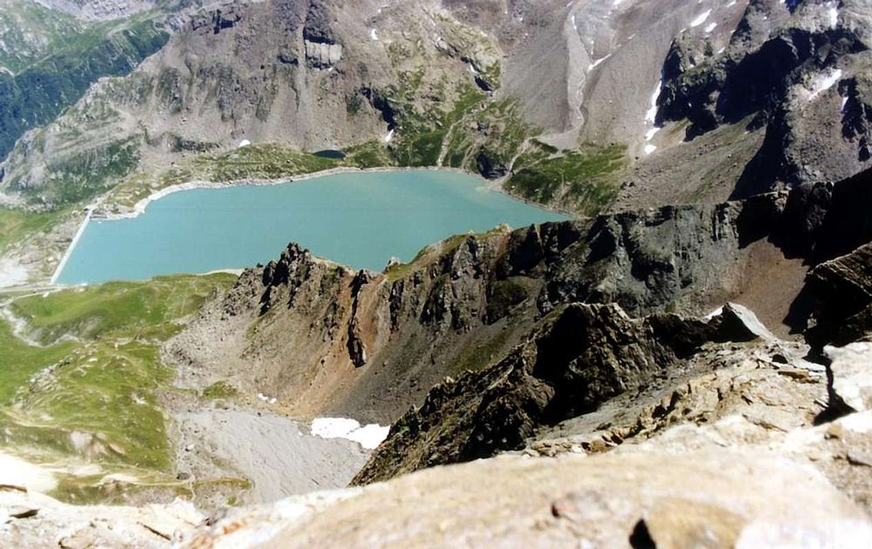
![]()
From the Summit towards Orco/Locana Valley with Ceresole's Artificial Dam, by Gianfranco Vicentini 1998
A) - Route from Benevolo through the Basey Pass and by the Northern Crest: coming to the deviation (2.707 meters) in left (Southeast) with Galisia Point Route from this point go up by path n° 13B along the enough step moraine as far as upper crossroads towards Nivoletta (Northeast) and Basei (East) Hills in altitude around 3.000 meters, by a more steep terminal part with bisordered stacking of stones arriving on the last pass (3.176m; E; 2h'30/3h'00). From this, climbing on easy Northern Crest or Standard Route, before bypassing to the left (East) an elevation 3.196 meters and after reaching the Top, paying attention to a passage in the final equipped with some lanynards (check the efficiency of the same; I°+/II°-) and exposed on the suspended Basei Glacier to the Northeast (EE/A; 0h'45/1h'00; from the Basei Pass; 3h'30/4h'00 altogether).
A) - Avvicinamento da Thumel verso il Rifugio Gian Federico Benevolo: dal Parcheggio (1.848 m) continuare verso Meridione tramite la strada verso l'Alpeggio (1.901 metri). Lasciando sulla sinistra quella che brevemente scende al piccolo Villaggio di Thumel (1.879 m), meritevole d'una visita insieme al vicino ponticello sito presso una profonda gola) e con sentiero n° 13 il medesimo si indirizza verso il Vallone della Grand Vaudala(z) con bella cascata frontalmente. Presso l'alpeggio si diparte invece il sentiero n° 13 per il Rifugio Gian Federico Benevolo (2.285 m) con abbondanti segnalazioni, che, passando sotto la caratteristica Chiesetta (1.936 metri), s'indirizza verso Sud-suovest seguendo dall'alto il corso della Dora di Rhêmes. Lasciando sulla destra (Ovest) la diramazione per l'Alpe di Fos, oltrepassare in un valloncello l'omonimo torrente raggiungendo, con percorso più verso Sudovest tra le praterie, gli Alpeggi di Saint-Pantaleon (2.010 m) e di Barmaverain (2.037 m). Subito dopo guadarne il torrente raggiungendo la località delle Cascate (2.051 m); con un breve diagonale, appena più ripido, e portarsi sulla soprastante strada sterrata poderale e, con percorso in falsopiano, pervenire al Ponte Romano sul torrente (2.125/30 metri circa). Da questo punto o continuare sulla stessa, che con due stretti tornanti sale all'Alpe Lavassey (2.227 m), oppure raggiungerla tramite una breve scorciatoia subito sopra il ponte; dall'alpeggio ancora per scorciatoia, o lungo la vicina poderale, raggiungere il rifugio, sito in un ampio promontorio erboso-roccioso (E/F; 1h'15/1h'30).
A) - Via dal Benevolo al Colle Basei e tramite la Cresta Settentrionale: giunti alla deviazione 2.707 metri verso Sudest, con la via della Punta Galisia, da questa risalire con il sentiero n° 13B lungo la morena sino alla superiore biforcazione a circa 3.000 metri per i Colli di Nivoletta (Nordest) e Basei (Est) raggiungendo con parte finale più ripida e tramite disordinati accatastamenti di pietre quest'ultimo colle (3.176 m; E; 2h'30/3h'00). Risalire alla Punta Basei per la facile nonché breve Cresta Nord o Normale, scavalcando od aggirando sulla sinistra (Est) dapprima la quota 3.196 metri e facendo attenzione nella parte finale ad un passaggio attrezzato con alcuni cordini (controllarne lo stato d'efficienza; I°+/II°-) ed alquanto esposto sul Ghiacciaio sospeso di Basei a Nordest verso il Pian del Nivolé (EE/A; 0h'45/1h'00; dal colle; 3h'30/4h'00 complessivamente).
B)- Approach from Pont Valsavarenche towards Col de Basei with ascent always through the Northern Ridge: from fork towards the Refuge Federico and Renato Chabod continue more in Southwest with Main Road and passing neighbor Maison Vieille, Pessey, Giomey, Donzel Pastures to Pont Djouan (1.994m; parking) and Pont Valsavarenche (1.951m; P.N.G.P. Cabin). Abandoning the terminal part of the short road to the Breuil locality (two camping, hotel-restaurant; fountain; departure to Refuges Vittorio Emanuele II°; office Valsavarenche Mountain Guide) continue through path in West to a splendid waterfall and impending Cross de La Roley (+; 2.319m) at ther entrance of Nivolé Tableland (11 Kilometres, the most high of Europe?). Changing Southwest and crossing Nivolé(t) Torrent on footbridge (2.377 meters) reach the Grand Collet Montagne (2.409m; in East path to Grand Collet Pass 2.832m), subsequent Nivolet Alp (2.407m; below Black Lake to West) up to two Nivolé Lochs (2.533/7m) just before Savoia (2.610m) and Città of Chivasso (2.600m) Refuges, at wide Nivolé(t) Hill (2.597m), below Northeastern Slope Punta Basei with homonym overhanging small glacier (F+; 4h '00/4h '15).
(*** Possibility of reaching the Nivolé or Nivolet Hill also from Piedmont Region with a good route in asphalt road, which goes up in the Valley of Locana or Ceresole's Reale or by Torrent of the Orco, passing after the Ceresole's Artificial Dam nearby Serrù ed Agnel Lakes. Various departures by Castellamonte small Town near Ivrea in Canavese Area.)
B)- Avvicinamento da Pont Valsavarenche al Col de Basei con salita sempre con la Cresta Nord: dal bivio per il Rifugio Federico e Renato Chabod continuare più a Sudovest tramite la Strada Regionale e passando nelle vicinanze degli Alpeggi di Maison Vieille, Pessey, Giomey, Donzel fino a quelli di Pont Djouan (1.994 m; parcheggio) e Pont Valsavarenche (1.951 m; Casotto del P.N.G.P.). Abbandonando la parte terminale della breve strada verso la località del Breuil (due campings, hotel-restaurant; fontana; partenze verso i Refugi Vittorio Emanuele II°; ufficio delle Guide di Valsavarenche) proseguire ad Ovest con il sentiero in direzione di una splendida cascata sovrastata dalla Croce de La Roley (+; 2.319 m) all'ingresso nel Pian del Nivolé (11 Kilometri, probabilmente il più alto altipiano d'Europa). Cambiando verso Sudovest ed attraversando il Torrente del Nivolé(t) su d'una passerella in legno (2.377 m) pervenire alla Montagna Grand Collet (2.409 m. Lasciando ad Est il sentierino per il Colle del Grand Collet 2.832m), raggiungere la successiva Alpe del Nivolet (2.407 m; sottostante il Lago Nero posizionato ad Ovest) sino ad arrivare ai due Laghi del Nivolé (2.533/7 m) appena prima dei Rifugi Savoia (2.610 m) e Città di Chivasso (2.600 m) donde al largo Colle del Nivolé(t) (2.597 m), al di sotto del Versante Nordest di Punta Basei con l'omonimo e sospeso ghiacciaietto (F+; 4h'00/4h'15).
(*** Possibilità di raggiungere il colle pur dal Piemonte tramite la strada asfaltata risalente la Valle di Locana o di Ceresole Reale conosciuta anche come Valle del Torrente dell'Orco, passando dopo la Diga di Ceresole presso i Laghi Serrù ed Agnel, con partenza dalla Cittadina di Castellamonte, presso d'Ivrea nella zona cosiddetta del Canavese).
From F/F+ to PD-.
Dal F/F+ al PD-.
A) - Via dal Benevolo al Colle Basei e tramite la Cresta Settentrionale: giunti alla deviazione 2.707 metri verso Sudest, con la via della Punta Galisia, da questa risalire con il sentiero n° 13B lungo la morena sino alla superiore biforcazione a circa 3.000 metri per i Colli di Nivoletta (Nordest) e Basei (Est) raggiungendo con parte finale più ripida e tramite disordinati accatastamenti di pietre quest'ultimo colle (3.176 m; E; 2h'30/3h'00). Risalire alla Punta Basei per la facile nonché breve Cresta Nord o Normale, scavalcando od aggirando sulla sinistra (Est) dapprima la quota 3.196 metri e facendo attenzione nella parte finale ad un passaggio attrezzato con alcuni cordini (controllarne lo stato d'efficienza; I°+/II°-) ed alquanto esposto sul Ghiacciaio sospeso di Basei a Nordest verso il Pian del Nivolé (EE/A; 0h'45/1h'00; dal colle; 3h'30/4h'00 complessivamente).
 |
 |
 |
 |
 |
B)- Approach from Pont Valsavarenche towards Col de Basei with ascent always through the Northern Ridge: from fork towards the Refuge Federico and Renato Chabod continue more in Southwest with Main Road and passing neighbor Maison Vieille, Pessey, Giomey, Donzel Pastures to Pont Djouan (1.994m; parking) and Pont Valsavarenche (1.951m; P.N.G.P. Cabin). Abandoning the terminal part of the short road to the Breuil locality (two camping, hotel-restaurant; fountain; departure to Refuges Vittorio Emanuele II°; office Valsavarenche Mountain Guide) continue through path in West to a splendid waterfall and impending Cross de La Roley (+; 2.319m) at ther entrance of Nivolé Tableland (11 Kilometres, the most high of Europe?). Changing Southwest and crossing Nivolé(t) Torrent on footbridge (2.377 meters) reach the Grand Collet Montagne (2.409m; in East path to Grand Collet Pass 2.832m), subsequent Nivolet Alp (2.407m; below Black Lake to West) up to two Nivolé Lochs (2.533/7m) just before Savoia (2.610m) and Città of Chivasso (2.600m) Refuges, at wide Nivolé(t) Hill (2.597m), below Northeastern Slope Punta Basei with homonym overhanging small glacier (F+; 4h '00/4h '15).
(*** Possibility of reaching the Nivolé or Nivolet Hill also from Piedmont Region with a good route in asphalt road, which goes up in the Valley of Locana or Ceresole's Reale or by Torrent of the Orco, passing after the Ceresole's Artificial Dam nearby Serrù ed Agnel Lakes. Various departures by Castellamonte small Town near Ivrea in Canavese Area.)
B)- Avvicinamento da Pont Valsavarenche al Col de Basei con salita sempre con la Cresta Nord: dal bivio per il Rifugio Federico e Renato Chabod continuare più a Sudovest tramite la Strada Regionale e passando nelle vicinanze degli Alpeggi di Maison Vieille, Pessey, Giomey, Donzel fino a quelli di Pont Djouan (1.994 m; parcheggio) e Pont Valsavarenche (1.951 m; Casotto del P.N.G.P.). Abbandonando la parte terminale della breve strada verso la località del Breuil (due campings, hotel-restaurant; fontana; partenze verso i Refugi Vittorio Emanuele II°; ufficio delle Guide di Valsavarenche) proseguire ad Ovest con il sentiero in direzione di una splendida cascata sovrastata dalla Croce de La Roley (+; 2.319 m) all'ingresso nel Pian del Nivolé (11 Kilometri, probabilmente il più alto altipiano d'Europa). Cambiando verso Sudovest ed attraversando il Torrente del Nivolé(t) su d'una passerella in legno (2.377 m) pervenire alla Montagna Grand Collet (2.409 m. Lasciando ad Est il sentierino per il Colle del Grand Collet 2.832m), raggiungere la successiva Alpe del Nivolet (2.407 m; sottostante il Lago Nero posizionato ad Ovest) sino ad arrivare ai due Laghi del Nivolé (2.533/7 m) appena prima dei Rifugi Savoia (2.610 m) e Città di Chivasso (2.600 m) donde al largo Colle del Nivolé(t) (2.597 m), al di sotto del Versante Nordest di Punta Basei con l'omonimo e sospeso ghiacciaietto (F+; 4h'00/4h'15).
(*** Possibilità di raggiungere il colle pur dal Piemonte tramite la strada asfaltata risalente la Valle di Locana o di Ceresole Reale conosciuta anche come Valle del Torrente dell'Orco, passando dopo la Diga di Ceresole presso i Laghi Serrù ed Agnel, con partenza dalla Cittadina di Castellamonte, presso d'Ivrea nella zona cosiddetta del Canavese).
DIFFICULTIES & EQUIPMENT
DifficultiesFrom F/F+ to PD-.
Dal F/F+ al PD-.
 |
 |
 |
 |
 |
Equipment
For Hiking or for Mountaineering, in relation to the season; in snow presence better with rope.
Da Escursionismo o da Alpinismo, relativamente alla stagione; con neve meglio se con corda.
For Hiking or for Mountaineering, in relation to the season; in snow presence better with rope.
Da Escursionismo o da Alpinismo, relativamente alla stagione; con neve meglio se con corda.
Camping
Strictly forbidden in Parco Nazionale del Gran Paradiso.
Mountain Conditions
- You can get meteo information at the official site of the Regione Valle d'Aosta:
- Valle d'Aosta Meteo
- Meteo: You can find more weather information on the website 3B Meteo:
- Meteo Rhemes Notre Dame
Webcam
- WEBCAM on Aosta Valley:
- Webcam
Books and Maps
BOOKS:
- "Guida dei Monti d'Italia-Gran Paradiso Parco Nazionale" E. Andreis, R. Chabod, M. C. Santis, Club Alpino Italiano/Touring Club Italiano, prima Ed. 1939; seconda Ed. 1963; terza Ed. 1980.
- "I Rifugi della Valle d'Aosta" di Stefano Ardito, Ed. Guide iter, Febbraio 2003.
- "Diari Alpinistici" di Osvaldo Cardellina e Indice Generale accompagnato da Schedario Relazioni Ascensioni 1964-2019 (inediti).
 |
 |
 |
MAPS:
- Kompass "Gran Paradiso Valle d'Aosta Sentieri e Rifugi" Carta Turistica 1:50.000.
- Enrico Editore Ivrea-Aosta "Gruppo del Gran Paradiso" 1:50.000.
- I.G.C. Istituto Geografico Centrale Torino "Valsavarenche Val di Rhemes Valgrisenche Parco Nazionale del Gran Paradiso", (carta n° 102), 1:25.000.
- I.G.C. Istituto Geografico Centrale Carta dei sentieri e dei rifugi "Il Parco Nazionale del Gran Paradiso" 1:5.0000.
Important Information
- REGIONE AUTONOMA VALLE D'AOSTA the official site.
- FONDAZIONE MONTAGNA SICURA Villa Cameron, località Villard de la Palud n° 1 Courmayeur (AO) Tel: 39 0165 897602 - Fax: 39 0165 897647.
- SOCIETA' GUIDE ALPINE DEL GRAN PARADISO Comune di Valsavarenche.
- A.I.NE.VA. (Associazione Interregionale Neve e Valanghe).
Useful numbers
- Protezione Civile Valdostana località Aeroporto n° 7/A Saint Christophe (Ao) Tel. 0165-238222.
- Bollettino Meteo (weather info) Tel. 0165-44113.
- Unità Operativa di Soccorso Sanitario Tel. 118.