
-
 17653 Hits
-
 88.19% Score
-
 26 Votes
|
|
Mountain/Rock |
|---|---|
|
|
45.47524°N / 7.11481°E |
|
|
Hiking, Mountaineering, Skiing |
|
|
Spring, Summer, Fall |
|
|
10951 ft / 3338 m |
|
|
Overview
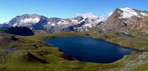
From Rosset lake, Punta Basei on the right and Levanne in the background
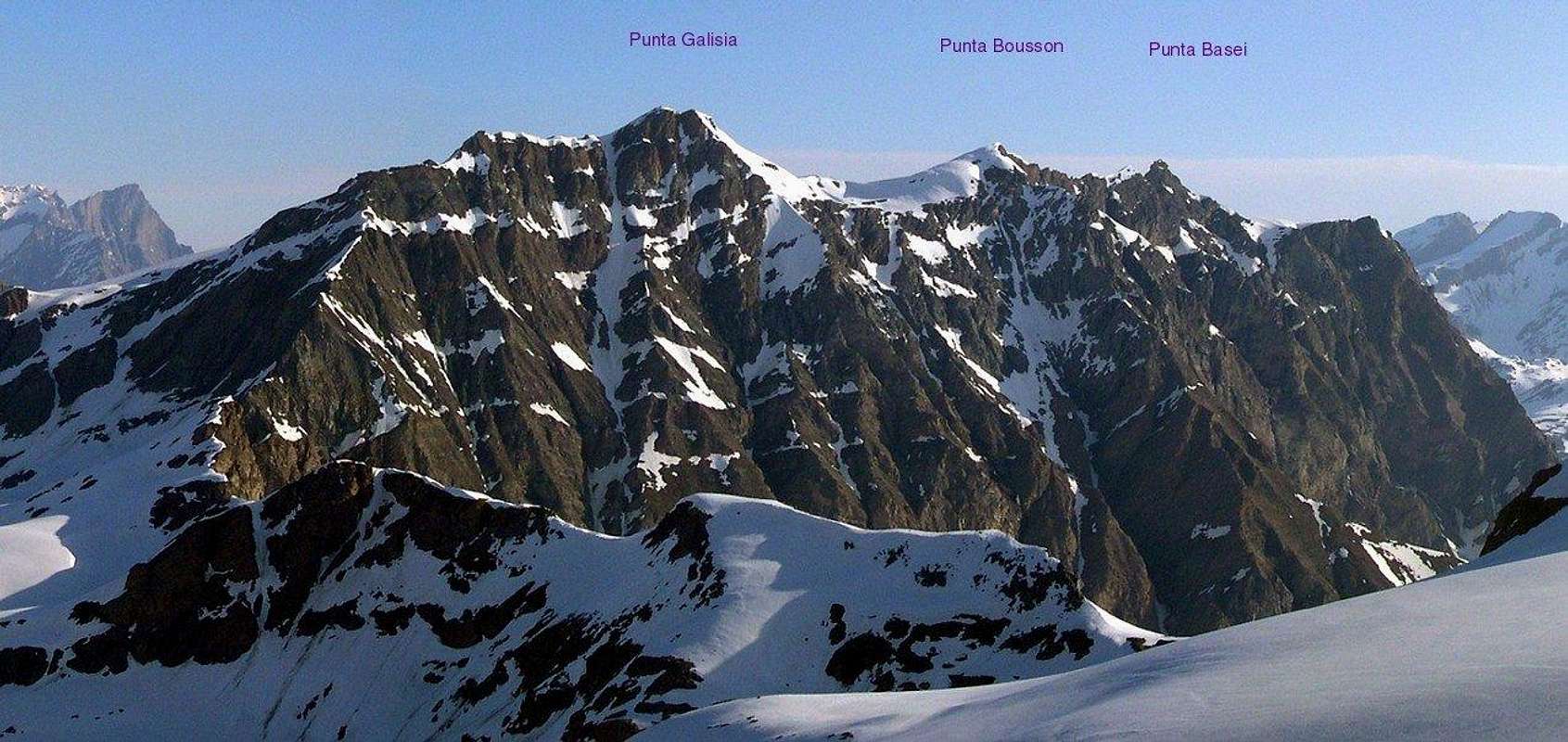
The watershed between Orco and Rhemes Valleys consists of some interesting and well-known summits; Punta Basei is one of them, it is the third summit of the ridge starting from W and is sometime considered part of a sort of subgroup formed of Punta Galisia (3346m), Punta Bousson (3337m) and Punta Basei (3338m), in fact on the maps of the XIX century these three summits were simply recognised as Galisia.
Its S and E sides belongs to Orco Valley, the first one is a 500m high wall of bad rock, while the E one is not particularly steep and is partially covered by the Basei Glacier that is fast-fading due to the more and more high temperatures of last years; the western one slopes down to the Rhemes valley, with the presence of Lavassey Glacier.
The notoriety of this mountain depends from the easy and relatively short access, in fact, when the road to Nivolet Pass is open (early June to late September), the summit is reachable in approximately three hours without alpine gear (required for the N side).
Along the last meters of the normal route, there is a window in the stone with a nice view to the most beautiful mountains of Rhemes Valley (see picture).
First known ascent: August 1875 by C. Poccardi and G. Blanchetti.
![Punta Basei <i>(3338m)</i> from Chabod Hut]()
![The large S wall of the ridge Basei, Bousson, Galisia]()
![Summit of Punta Basei]() Height difference: 756mDifficulty: easy alpinismPark the car just 50 meters under Nivolet Pass Valsavarenche side. Follow the trail to Colle Leynir, then turn left and walk on the path to colle Basei. Arrived at the base of Basei Glacier, walk on the glacier or along its edge, keeping the direction to the summit. Climb the last rocks finding one passage aided by a fixed rope and walk along the last 10 meters of horizontal ridge. Approximately same route for skinners except in the early spring when the road could be closed at Lago Agnel (2300m), Lago Serrù (2225m) or before.Other routes:
Height difference: 756mDifficulty: easy alpinismPark the car just 50 meters under Nivolet Pass Valsavarenche side. Follow the trail to Colle Leynir, then turn left and walk on the path to colle Basei. Arrived at the base of Basei Glacier, walk on the glacier or along its edge, keeping the direction to the summit. Climb the last rocks finding one passage aided by a fixed rope and walk along the last 10 meters of horizontal ridge. Approximately same route for skinners except in the early spring when the road could be closed at Lago Agnel (2300m), Lago Serrù (2225m) or before.Other routes:
![Punta Basei: fixed rope on the final ridge]() Rifugio Benevolo, 2285m, CAI Torino. Teleph. n. +39.0165.936143. 61 beds, 5 beds winter side. Usually open even in spring for ski-mountaineering in higher Val di Rhêmes.Rifugio Città di Chivasso, 2606m - located just under Nivolet Pass. - Phone: +39.0124.953150 - 70 places (6 places in winter room) Albergo Savoia, 2532m at Nivolet lakes. - Phone: +39.0165.94141 - 65 places.
Rifugio Benevolo, 2285m, CAI Torino. Teleph. n. +39.0165.936143. 61 beds, 5 beds winter side. Usually open even in spring for ski-mountaineering in higher Val di Rhêmes.Rifugio Città di Chivasso, 2606m - located just under Nivolet Pass. - Phone: +39.0124.953150 - 70 places (6 places in winter room) Albergo Savoia, 2532m at Nivolet lakes. - Phone: +39.0165.94141 - 65 places.
![Levanne seen from the normal route to Punta Basei]() All routes are within Parco Nazionale del Gran Paradiso: dogs or other animals are not allowed. Camping is strictly forbidden (except for emergency from sunset 'til dawn). Any fees required nor parking permits. Ceresole Reale - Nivolet Pass paved road: Seasonal opening from early June to the end of September. During Sat and Sun in July and August, engine vehicles (cars, campers and motorbikes) must stop in Serrù dam car park. Bus mandatory to Nivolet pass.Further details at P.N.G.P. official site.
All routes are within Parco Nazionale del Gran Paradiso: dogs or other animals are not allowed. Camping is strictly forbidden (except for emergency from sunset 'til dawn). Any fees required nor parking permits. Ceresole Reale - Nivolet Pass paved road: Seasonal opening from early June to the end of September. During Sat and Sun in July and August, engine vehicles (cars, campers and motorbikes) must stop in Serrù dam car park. Bus mandatory to Nivolet pass.Further details at P.N.G.P. official site.
Meteo France2
Météo Savoie 08 92 68 02 73
Its S and E sides belongs to Orco Valley, the first one is a 500m high wall of bad rock, while the E one is not particularly steep and is partially covered by the Basei Glacier that is fast-fading due to the more and more high temperatures of last years; the western one slopes down to the Rhemes valley, with the presence of Lavassey Glacier.
The notoriety of this mountain depends from the easy and relatively short access, in fact, when the road to Nivolet Pass is open (early June to late September), the summit is reachable in approximately three hours without alpine gear (required for the N side).
Along the last meters of the normal route, there is a window in the stone with a nice view to the most beautiful mountains of Rhemes Valley (see picture).
First known ascent: August 1875 by C. Poccardi and G. Blanchetti.
  |
Getting There
By carNorth side:

- From Turin/Milan. Motorway A5, exit in Aosta Ovest. Follow Courmayeur direction, until reached Villeneuve. Follow for Val di Rhêmes direction.
- From Switzerland, Martigny (Grand St. Bernard Tunnel/Pass). Drive to Aosta, then follow Courmayeur direction on SS.26. Once reached Villeneuve, turn for Val di Rhêmes.
- From France (Mont Blanc Tunnel or Petit St. Bernard Pass). Do not enter in motorway A5, drive through SS.26 Aosta direction. Before arriving in Villeneuve, turn right for Val di Rhêmes direction.
South side:

- From Turin. Motorway A5, exit in Scarmagno. Follow for Castellamonte, then Cuorgnè, then Ceresole Reale or Parco Nazionale del Gran Paradiso.
- From Milan. Motorway A4, after Santhià exit, turn to Aosta direction (A5 motorway). Once arrived on A5, following Aosta direction first exit is Ivrea, while following Turin direction first exit is Scarmagno. Best one (easier road) is Ivrea.
By train/busTrain to Aosta from Turin or Milan then local bus to Rhêmes Notre Dame. Timetables here.Local train from Torino to Pont Canavese, then bus to Ceresole Reale and Nivolet Pass. Timetables here.
Nearest Airports: Milano 193 km; Torino 95 km; Geneva 165 km.
Routes
Normal route, E side
- W face: steep slope of snow or ice (depends from the season) practicable coming from Rifugio Benevolo, best in spring.
- SW ridge, coming from Punta Bousson: quite frequented during the enchainment of Galisia, Bousson, Basei. Aerial ridge practicable with alpine gear. The enchainment is advisable for the panoramas and the variety of terrains.
- SE spur: 500 meters high climbing route of bad rock. Not advisable.
Huts

Red Tape

When to climb
Alpinism/hiking: June to November. Ski-mountaineering: April to June.
 |
Books and maps
Books:Guida dei monti d'Italia di E.Andreis,R. Chabod, M.C. Santi GRAN PARADISO ed. TCI Maps:IGC 1/50000 Gran Paradiso
Weather and snow conditions
Weather forecastsPiemonte and Valle d’AostaPiemonteThe borderline with France isn’t so far from Basei:Meteo France2
Météo Savoie 08 92 68 02 73
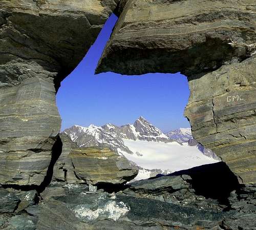
The window of Punta Basei