
-
 6866 Hits
-
 84.27% Score
-
 18 Votes
|
|
Mountain/Rock |
|---|---|
|
|
46.54446°N / 10.39672°E |
|
|
Hiking |
|
|
Spring, Summer, Fall |
|
|
9665 ft / 2946 m |
|
|
Overview
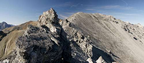 Punta di Rims as seen from the ridge traverse from Piz Umbrail Punta di Rims as seen from the ridge traverse from Piz Umbrail |
Punta di Rims is a panoramic mountain in the north of the Ortler / Cevedale Group. While often the group is thought to end at Stilfser Joch / Passo di Stelvio and the corresponding valleys to the east and west of it, technically two more subgroups can be found on its northern side: Fallatschkamm / Cresta di Vallazza in the north-east and the Umbrail-Group to the west. Both are separated by Umbrailpass / Giogo di Santa Maria (also Wormser Joch in its old German name), which at 2506m serves as one of the main trailheads in the area.
The main summit, obviously, is Piz Umbrail, after which the whole subgroup has been named, an often climbed limestone 3000er with a rocky, broken south face. Piz Umbrail is connected by one of the most panoramic ridges of the area with Punta di Rims, its neighbour to the west. If you look up Punta di Rims in the guidebook of the German Alpine Club you'll find the short laconic description: "only worthwhile to climb if in conjection with the traverse from or to Piz Umbrail", a judgement from which I tend to disagree for two reasons: views and history.
 Looking from the summit of Punta di Rims towards the Sesvenna Group in the north
The mountain - as said above - is very panoramic being located just across Valle del Braulio from the central Ortler / Cevedale Group. Thus it offers perfect views on the glaciated peaks of the group, while also showcasting the Umbrail-Group itself as well as the Sesvenna Group a little to the north. Through Münstertal / Val Müstair you can see as far as Weisskugel / Palla Bianca in the Ötztal Alps while in the opposite direction the glaciers of the Bernina Groupgleam in the sunlight.
As for history - see the following section.
The highlight of a climb of Punta di Rims clearly is the ridge traverse from Piz Umbrail. Technically it is not exactly demanding but the absolutely rotten rock quality of Piz Umbrail ensures that you'll never feel absolutely comfortable. Thus it is attempted only by a minority of the many Umbrail summiters and a much quieter destination. Its other route, from Umbrailpass through Bocchetta di Forcola is a classic hiking route, frequented quite often, especially by mountain bikers, but most forgo the climb to the summit and return instead.
World War I around Stilfser Joch / Passo di Stelvio
 The central Ortler Group behind WW I fortifications
The area around Stilfser Joch / Passo di Stelvio was heavily contested during WW I, like so many other alpine ridges on the former Austrian - Italian border. The two countries fought a heavy mountain war, remnants of which you can discover all across the Eastern Alps. While the heaviest fighting occured on the Isonzo Front in which now is the border area between Italy and Slovenia as well as around Plöckenpass in the Carnic Alps, here on the westernmost part of the front fighting was slightly less fierce. The presence of the neutral Swiss troops ensured that both warring nations had to take care not to accidentally attack their neutral neighbour. Even the Swiss airspace was not allowed to be penetrated by Italian or Austrian artillery.
Consequently both warring nations tried to build their positions (and barracks) as close as possible to the Swiss ones, trying to ensure safetty from enemy fire. On Punta di Rims, for instance, you can find the ruins of two barracks back to back - one Italian, one Swiss. On Dreisprachenspitze / Cima Garibaldi just across Umbrailpass, Austrians had built a whole barracks city next to their neutral neighbours.
On the otther hand the population of the area had to suffer most. While the Lombardian part of the region (west of Stilfser Joch / Passo di Stelvio) was only sparsely populated, on the South Tyrolian part in the east three villages had to take the full force of the artillery attacks. In addition most of the male population had been drafted either to fight or as support. Like in all the other fighting zones along the front winter with its harsh temperatures and avalanches proved as devastating as the actual fighting.
 In a WW I mine In a WW I mine |  Ortler seen from the mine Ortler seen from the mine |  Lunch among WW I fortifications Lunch among WW I fortifications |
Today you can still find proof of the fighting on all sides of Stilfser Joch / Passo di Stelvio. All three nation left their marks on the landscape and you'll find many a trench, mine or ruined building without even having to search. Two theme trails have been created along the old defense positions, Sentiero Life in the north, Sentiero della Pace in the south to commemorate WW I. The latter runs all the way from Bormio across the whole former frontier until it ends near Marmolada in the central Dolomites.
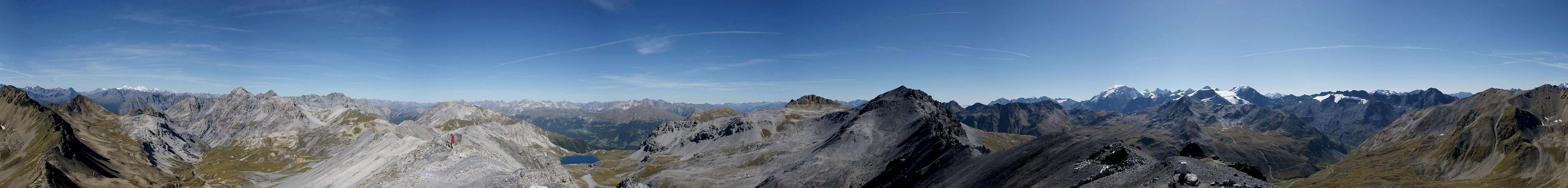
360° Summit Panorama
  |
Getting There
 Punta di Rims as seen from Bocchetta di Forcola
The trailhead for Punta di Rims is at Umbrailpass / Giogo di Santa Maria / Wormser Joch. The pass is located only a few kilometres away from Stilfser Joch / Passo di Stelvio, Europe's highest road pass. It can be easily reached though Stilfser Joch should be avoided due to the usual heavy traffic.
From South Tyrol / Alto Adige
- Take SS38 from Bozen / Bolzano through Meran / Merano and Vinschgau / Val Venosta.
- At Spondinig / Spondigna the road turns off in direction of Stilfser Joch Passo di Stelvio.
- Drive across the pass (48 switchbacks!) and on to Umbrailpass. Park at the Italian - Swiss border.
- Alternatively, at Spondinig / Spondigna turn onto SS40 to Schluderns / Sluderno.
- Here turn onto SS41 which leads into Switzerland.
- Called B28 there the road leads to Santa Maria, where the road to Umbrailpass turns off south.
- The road is open from 6 a.m. through 8 p.m.
From Lombardia
- Take SS38 direction Stilfser Joch / Passo di Stelvio.
- Shortly before you reach the pass the Umbrailpass road turns off left (north).
From Graubünden
- Take B28 across Ofenpass / Pass dal Fuorn until you reach Santa Maria.
- Here turn south onto the road to Umbrailpass (open 6 a.m. through 8 p.m.).
From Austria
- From Landeck take B180 across Reschenpass / Passo di Resia into South Tyrol / Alto Adige.
- The road, SS40 in Italy, takes you to Mals / Malles Venosta.
- Here, turn onto a side road through Laatsch / Laudes, which heads for Switzerland, joining SS41 several kilometres in front of the border.
- In Switzerland follow B28 to Santa Maria, where you turn onto the road to Umbrailpass (open 6 a.m. - 8 p.m.).
Red Tape
 Parnassius phoebus
Unlike the mountains on the other side of Valle del Braulio, the mountains of the Umbrail-Group are not part of any natural or national park. However, Punta di Rims is located on the border between Italy and Switzerland and while border controls are scarce they might occur. Switzerland is not part of the EU which requires you to definitely carry ID or passport with you.
And once again: the border on Umbrailpass is open only between 6 a.m. and 8 p.m. so that during the night you might be forced to take a rather long detour depending on your destination.
Accommodation
- Vinschgau / Val Venosta
- Val Müstair / Münstertal
- Lombardia (select region "Lombardia" and/or town "Bormio")
Weather Conditions
Maps & Books
Maps
- Nationalpark Stilfserjoch / Parco Nazionale dello Stelvio
Kompass Map WK072
1:50000
ISBN: 3-85491-391-5
Books
- Unterengadin
R. and S. Weiss
Rother Verlag
ISBN: 3-7633-4043-2
- Ortleralpen
P. Holl
Alpenvereinsführer
Rother Verlag
ISBN: 3-7633-1313-3