
-
 5763 Hits
-
 83.1% Score
-
 16 Votes
|
|
Area/Range |
|---|---|
|
|
46.55581°N / 10.35141°E |
|
|
Hiking, Mountaineering, Scrambling, Skiing |
|
|
Spring, Summer, Fall, Winter |
|
|
10433 ft / 3180 m |
|
|
1 - Overview
 Piz Schumbraida seen through Valle Forcola Piz Schumbraida seen through Valle Forcola |
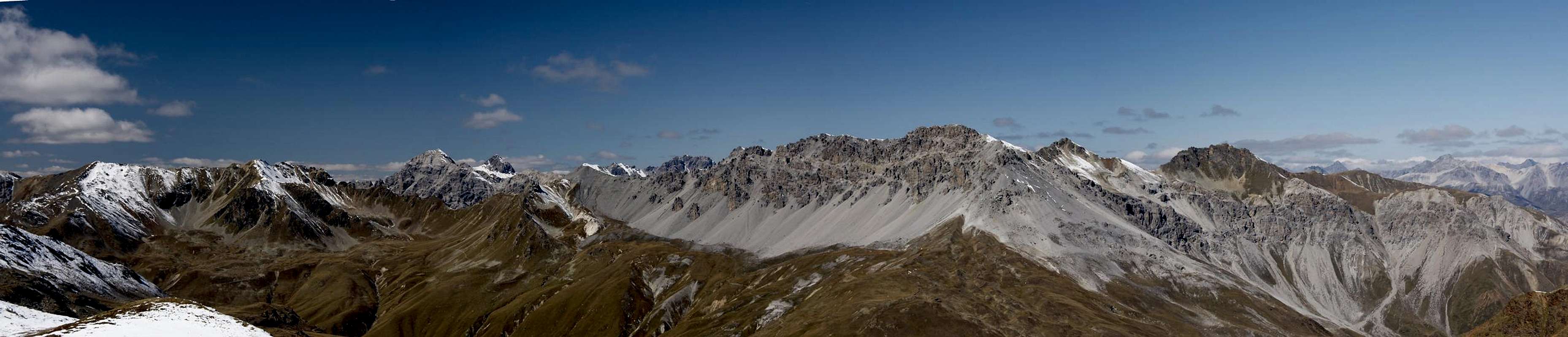
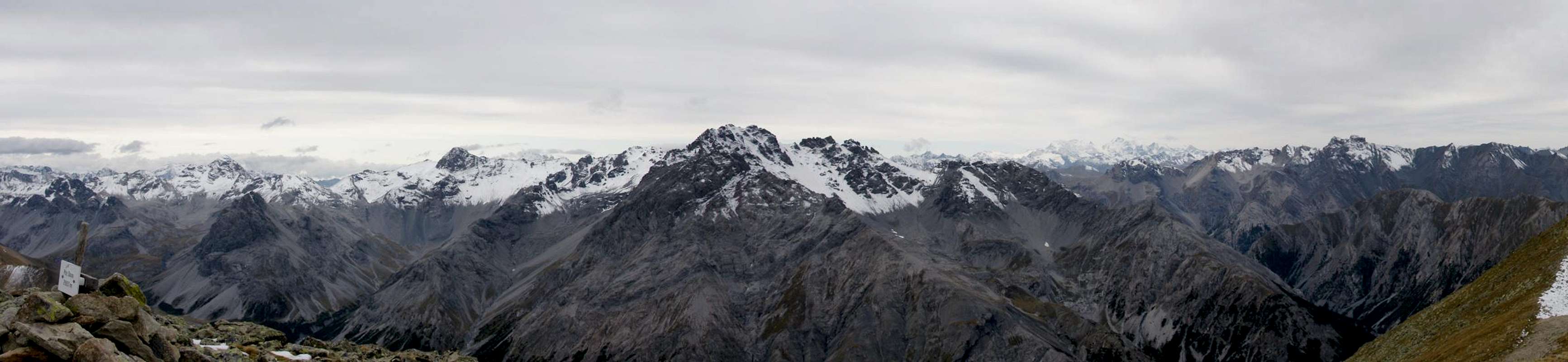
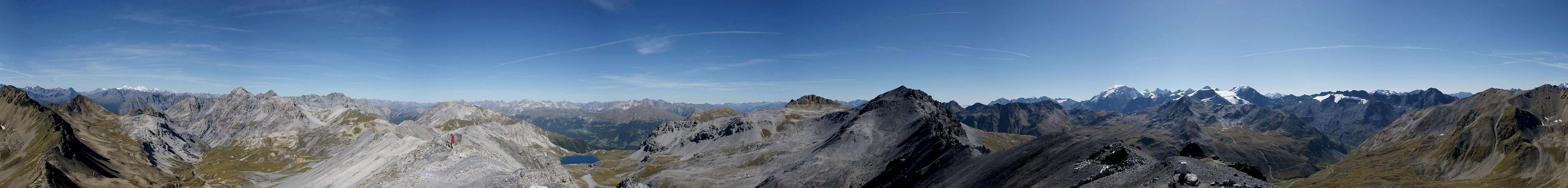
The Ortler / Ortles Group is one of the largest mountain groups of the eastern Alps. It divides into ten subgroups, of which the ones in the vicinity of Ortler / Ortles itself are the most important and highest ones. In the area their glaciated mountains attract most attention while lower and lesser summits are veritably overlooked. Still, this central part makes up only about a third of the whole range while the other two thirds can be found in its north-west or the east. In the north-west SS38, the road which leads from Bormio to Trafoi across Stilfser Joch / Passo dello Stelvio separates two subranges from the central Ortler / Ortles Group, Fallaschkamm / Cresta Valazza in the east and the Umbrail Group in the west.
Named after its easternmost cornerstone, Piz Umbrail and the associated Umbrailpass / Giogo di Santa Maria, the subgroup differs in most aspects from the remainder of its mother range. Most important of all, the Umbrail Group is made up from brittle limestone, rather than the eruptive rocks the remainder of the Ortler / Ortles is made up from It rather resembles the Sesvenna Group to its north and sometimes the mountains of both groups are referred to as Engadin Dolomites. Of the group only very few mountains are regularly climbed: there are hiking trails to only half a dozen mountains: Piz Umbrail, Punta di Rims, Piz Praveder, Piz Turettas, Piz Daint, Piz Dora and Munt la Schera. Far from being difficult, the remainder of the mountains of the group lead a very solitary existence with few ski tour ascents during winter.
 |  |  |
The Umbrail Group is located on the Swiss - Italian border. It is bounded by Val Muraunza in the east, Val Müstair in the north, Val Gallo and Valle di Fraéle in the south-west as well as Valle del Braulio in the south-east. The group consists of three subranges, two ridges and a loose assortment of lesser mountains. The Main Ridge at the same time is the border between Switzerland and Italy and consists of the highest mountains of the group. Half a dozen mountains surmount 3000m with Piz Murtaröl / Cima la Casina being the highest one at 3180m. To the north, separated from the main ridge by Val Mora, there is a second smaller and lower ridge. Its highest mountain is Piz Dora at 2968m). The third group, a loose assortment of four summits is located in the very west of the group and topped by Cima del Seraglio (2684m).
The area around Stilfser Joch / Passo di Stelvio was heavily contested during WW I, like so many other alpine ridges on the former Austrian - Italian border. The two countries fought a heavy mountain war, remnants of which you can discover all across the Eastern Alps. While the heaviest fighting occured on the Isonzo Front in which now is the border area between Italy and Slovenia as well as around Plöckenpass in the Carnic Alps, here on the westernmost part of the front fighting was slightly less fierce. The presence of the neutral Swiss troops ensured that both warring nations had to take care not to accidentally attack their neutral neighbour. Even the Swiss airspace was not allowed to be penetrated by Italian or Austrian artillery.
 Ortler as seen through a WW I mine
Consequently both warring nations tried to build their positions (and barracks) as close as possible to the Swiss ones, trying to ensure safety from enemy fire. On Punta di Rims, for instance, you can find the ruins of two barracks back to back - one Italian, one Swiss. On Dreisprachenspitze / Cima Garibaldi just across Umbrailpass, Austrians had built a whole city of barracks next to their neutral neighbours.
Today you can still find proof of the fighting on all sides of Stilfser Joch / Passo di Stelvio. All three nation left their marks on the landscape and you'll find many a trench, mine or ruined building without even having to search. Two theme trails have been created along the old defense positions, Sentiero Life in the north, Sentiero della Pace in the south to commemorate WW I. The latter runs all the way from Bormio across the whole former frontier until it ends near Marmolada in the central Dolomites.
2 - The Umbrail Group on SP
  |
Thanks to the aforementioned obscurity of the group and even though most parts of it are easily reachable by car there is only a small number of mountains posted to SP. They are the ones with the shortest or easiest access routes.
- Umbrail Group
3 - The Summits
|
The following listing follows the Alpenvereinsführer (German Alpine Club guidebook , see list of books below). Where possible, I listed both the German and Rhaetian names. In general you can say that Rhaetian names dominate on the Swiss side of the border while the Italian ones can be found in the south. However, some of the summits bear names in both languages. As for the elevations, there have been at least two measurements for the whole range. Here I stick with the younger Italian ones.
- Piz Umbrail (3031m)
![]()
- Piz Chazfora (3006m)
- Piz Rims (2965m)
- Munt da Milli Ons (2816m)
- Piz Lad (2882m)
![]()
- Pizzet (2561m)
- Piz Mezdi (2668m)
- Punta di Rims (2946m)
![]()
- Monte Braulio (2980m)
![]()
- Monte Radisca (2970m)
- Corno di Radisca (2934m)
- Monte Pendenolo (2780m)
- Piz dal Lai (2826m)
- Piz Praveder (2768m)
- Monte Forcola (2906m)
- Piz Schumbraida (3124m)
![]()
- Monte Solena (2919m)
- Cucler da Jon dad Onsch (2827m, 2775m)
- Piz Tea Fondada / Monte Cornaccia (3144m)
- Piz Magliavachas (3044m, 3088m)
- Piz Murtaröl / Cima la Casina (3180m)
![]()
- Piz Pala Gronda (3002m)
- Mon’Ata (2730m)
- Piz Mon’Ata (2938m)
3.2 - North Ridge
- Piz dal Döss Radond (2906m)
- Piz Turettas (2963m)
![]()
- Piz Chazfora (2783m)
![]()
- Piz Dora (2951m)
![]()
- Piz Daint (2968m)
![]()
- Piz Gialet / Il Jalet (2392m)
3.3 - Western Summits
- Cima del Serraglio (2685m)
- Munt Buffalora (2630m)
- Muot Chavagl / Munt Chavagl (2542m)
- Munt la Schera (2590m)
3.1 - Main Ridge
 |


4 - Getting There
 |
The fact that the Umbrail Group is surrounded by roads on all sides might imply that he group can be easily reached. However, it lies in a region far away from the cities of Italy, Switzerland or Austria so that itineraries are lengthy.
From South Tyrol / Alto Adige
- Take SS38 from Bozen / Bolzano through Meran / Merano and Vinschgau / Val Venosta.
- At Spondinig / Spondigna the road turns off in direction of Stilfser Joch Passo di Stelvio.
- Drive across the pass (48 switchbacks!) and on to Umbrailpass or down in the direction of Bormio (for the southern parts of the Umbrail Group..
- Alternatively, at Spondinig / Spondigna turn onto SS40 to Schluderns / Sluderno.
- Here turn onto SS41 which leads into Switzerland.
- Called B28 there the road leads to Santa Maria, where the road to Umbrailpass turns off south (open from 6 a.m. through 8 p.m.).
- For the western parts of the group stay on B28 towards and across Ofenpass / Pass dal Fuorn.
From Lombardia
- Take SS38 direction Stilfser Joch / Passo di Stelvio.
- At Bormio you can turn onto SP301, to Livigno for the western parts of the Umbrail Group.
- For the eastern parts stay on SS38.
- Shortly before you reach Stilfser Joch / Passo di Stelvio the Umbrailpass road turns off left (north).
From Graubünden
- Take B28 across Ofenpass / Pass dal Fuorn until you reach Santa Maria.
- Here turn south onto the road to Umbrailpass (open 6 a.m. through 8 p.m.).
From Austria
- From Landeck take B180 across Reschenpass / Passo di Resia into South Tyrol / Alto Adige.
- The road, SS40 in Italy, takes you to Mals / Malles Venosta.
- Here, turn onto a side road through Laatsch / Laudes, which heads for Switzerland, joining SS41 several kilometres in front of the border.
- At Santa Maria, the road to Umbrailpass (open 6 a.m. - 8 p.m.) turns off.
- For the western parrts of the group stay on B28 to and across Ofenpass / Pass dal Fuorn.
5 - Accommodation
- Val Müstair / Münstertal
- Lombardia (select region "Lombardia" and/or town "Bormio")
- Vinschgau / Val Venosta
6 - Red Tape
The bulk of the Umbrail Group has no red tape or restrictions. However, in the southern part - on the Italian side of the border - some parts of the group belong to the Nationalpark Stilfser Joch / Parco Nazionale dello Stelvio where the usual restrictions apply. Some parts in the north-west of the group (west of Ofenpass / Pass dal Fuorn) Belong to Schweizerischer Nationalpark / Parco Nazionale Svizzero which has severe restrictions. For instance you are not allowed to leave trails or to park cars only in designated areas.Find more information on the websites of the respective parks:
- Nationalpark Stilfser Joch / Parco Nazionale dello Stelvio
- Schweizerischer Nationalpark / Parco Nazionale Svizzero
The road between Santa Maria and Umbrailpass is open only during daytime (6 a.m. - 8 p.m.). Outside that timeframe langthy detours are the rule.
7 - Weather Conditions
8 - Maps & Books
8.1 - Maps
- Nationalpark Stilfserjoch / Parco Nazionale dello Stelvio
Kompass Map WK072
1:50000
ISBN: 3-85491-391-5
8.2 - Books
- Unterengadin
R. and S. Weiss
Rother Verlag
ISBN: 3-7633-4043-2
- Ortleralpen
P. Holl
Alpenvereinsführer
Rother Verlag
ISBN: 3-7633-1313-3