
-
 9147 Hits
-
 82.48% Score
-
 15 Votes
|
|
Route |
|---|---|
|
|
45.91983°N / 7.87082°E |
|
|
Mountaineering, Ice Climbing |
|
|
Spring, Summer |
|
|
Half a day |
|
|
Alpine PD |
|
|
Approach
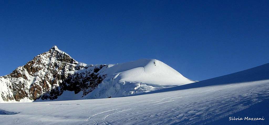
Punta Parrot traverse
Punta Parrot/Parrotspitze 4432 m is a mountain belonging to the Monte Rosa Group, Pennine Alps. The mountain has the shape of a long and sharp ridge in the West-East direction and is located between the Eastern Lyskamm and the Punta Gnifetti. It's separated from the Eastern Lyskamm by the Colle del Lys 4248 m and from Punta Gnifetti by the Colle Sesia 4299 m. In the Monte Rosa group there is an impressive sequence of 4000s, located close to each other, and Punta Parrot is part of this one: Punta Dufour, Punta Zumstein, Punta Gnifetti, Ludwigshöhe, Corno Nero and Piramide Vincent are the other peaks that make up this extraordinary icy circle. Check here the complete list of the 82 alpine Fourthousanders and the 46 minor summits: Club4000.
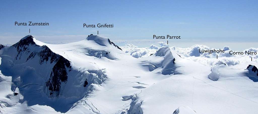
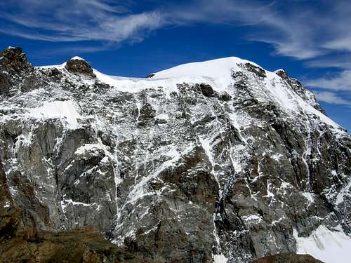
Punta Parrot is located on the border ridge between Italy and Switzerland and shows two contrasting slopes, as it happens for some of the nearby mountains: the North side is gently angled and snowy, while the South face, facing the Italian side appears like a very high and wide wall of rock and snow overlooking the Val Sesia. In fact Punta Parrot is part of the famous and severe Parete Valsesiana del Monte Rosa, together with Punta Giordani, Piramide Vincent, Corno Nero and Punta Gnifetti.
The name Punta Parrot comes from the German physician Johann Jakob Friedrich Wilhelm Parrot, who made an attempt to climb the Vincent Pyramid with Joseph Zumstein in the year 1816. Punta Parrot was first climbed several years later, on August 16, 1863, by the British Reginald S. MacDonald, Florence Crauford Grove, Montagu Woodmass, with the guides Melchior Anderegg and Peter Perren.
Getting there
Two different road approachs are possible depending if coming from the Valle di Gressoney (Aosta) or from Val Sesia.
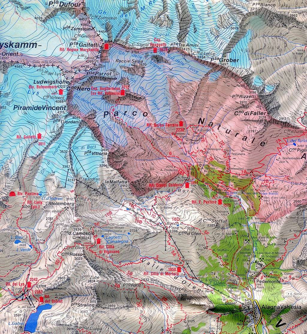
Access via Valle di Gressoney (Aosta Valley) - From the A5 Torino – Aosta Highway, exit to Pont St. Martin and take the Valle di Gressoney, getting to Gressoney St. Jean, Gressoney La Trinité and Staffal. From Staffal take the Cable car to Alpe Gabiet – Passo dei Salati - Indren
Access via Val Sesia (Piedmont) - From the A26 Highway exit to Romagnano Sesia and take the road to Varallo Sesia. Here continue following all the Val Sesia road to Alagna Valsesia. From Alagna Valsesia take the Cable car to Pianalunga - Passo dei Salati – Nuova Indren 3275 m
There are several ways to get to the two mountain huts (Rifugio Mantova and Capanna Gnifetti) from the valley. The different approach routes are described below.
Access to the Rif. Città di Mantova 3498 m and Rif. Gnifetti 3611 m
Get to the Rif. Gnifetti from Punta Indren, 3260 m (cable car from Alagna or Gressoney) in 1,5 h via the Rif. Città di Mantova, 1 h to Rif. Città di Mantova. In the lower part, it is a marked path (n. 5). The traverse of the glacier is not marked. From Punta Indren, traverse the ski-run, slowly going up on the Indrenglacier till you reach the outstanding rock band above which the Mantova-hut is situated (yellow-red signs). You climb up the rock steps (fixed ropes). To reach the Gnifetti Hut from the Mantova Hut you have to cross the glacier going up over the E-side of the glacier to the N and at the end on the rocks to the Gnifetti hut. This will take up to 30 minutes longer.
Route Description
Punta Parrot traverse
Difficulty: PD (Alpine scale)
Difference in level: 830 m from Capanna Gnifetti - 965 m from Rifugio Mantova - 1160 m from Indren
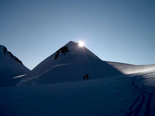
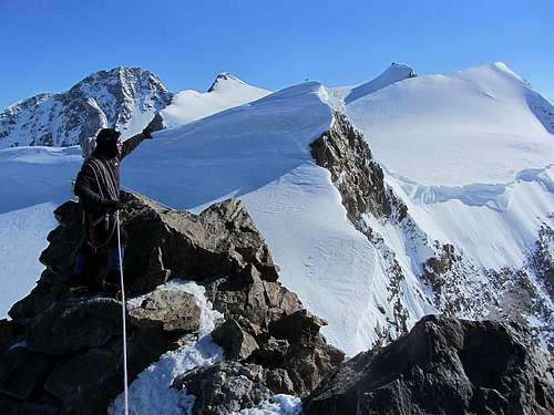
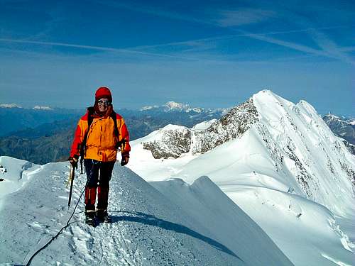
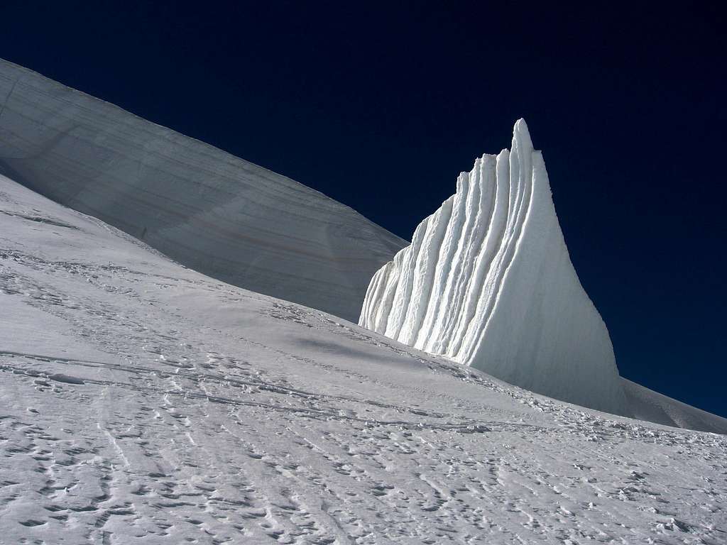
Punta Parrot is a minor summit in the Monte Rosa group, anyhow the climb is a must for those looking for a fine itinerary on a high mountain. The peak is often linked in crossing with the other adjacent 4000s, Ludwigshohe and Corno Nero. The itinerary suggested is a superb ring following a sharp and very aesthetic ridge with easy climb and can also be done in the opposite direction to that one described. The approach involves a full glacier's equipment. Lys Glacier has several crevasses - often hidden in early summer - so it is necessary to cross it by proceeding enroped.
Route description - The approach to Punta Parrot starts from either Capanna Gnifetti m. 3611 and Rifugio Mantova m. 3470. From the shelters – Rifugio Mantova or Capanna Gnifetti – gain the starting point of the Lys Glacier, which begins nearby Capanna Gnifetti. Enter the glacier and follow it at first diagonally to the left (toward North-East) along a steep ramp, then toward North rising on moderate ice-slopes, never too away from the steep slopes of Piramide Vincent. In some sections the route presents a few passages between wide crevasses. Continue always along the track, usually present in summer, heading to the Colle del Lys.
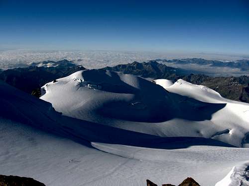
After passing a series of irregular slopes, the itinerary gets the snowy basin below the Balmenhorn at about 4000 m. with the statue of Christ under which it's located the little bivouac. Finally, the route reaches the Colle del Lys 4248 m, just near Eastern Lyskamm, located to the left. Here, leave the track heading to Punta Gnifetti and slightly to the right head towards the col between the Ludwigshohe and the Parrot. Without reaching it, with a traverse to the left, gain the West ridge above a rocky outcrop, then follow the airy ridge.
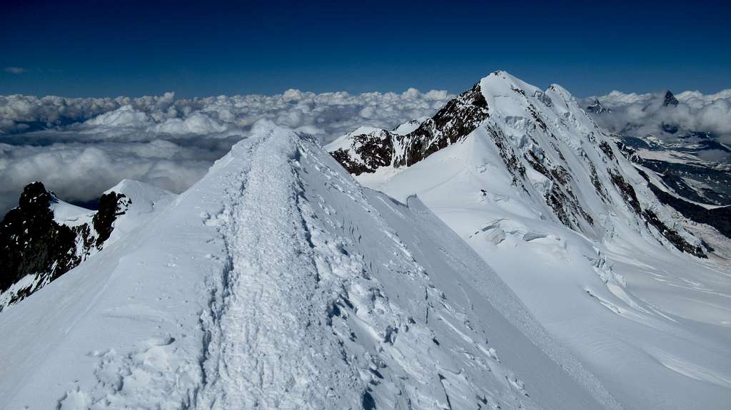
Finally, the route reaches the Colle del Lys 4248 m, just near Eastern Lyskamm, located to the left. Here, leave the track heading to Punta Gnifetti and slightly to the right head towards the col between the Ludwigshohe and the Parrot. Without reaching it, with a traverse to the left, gain the West ridge above a rocky outcrop, then follow the airy ridge. After a steeper section, the ridge becomes gently angled, reaching the summit. From the summit continue following the airy but wider North-East ridge descending towards the Colle Sesia 4299 m. From here the descent route joins the trail to Punta Gnifetti. Take it to the left to come back to the Colle del Lys.
The itinerary can also be climbed in the opposite direction.
Essential Gear
Rope, ice axe, crampons.
Red Tape
There are no particular permits required to climb the peak.
Huts
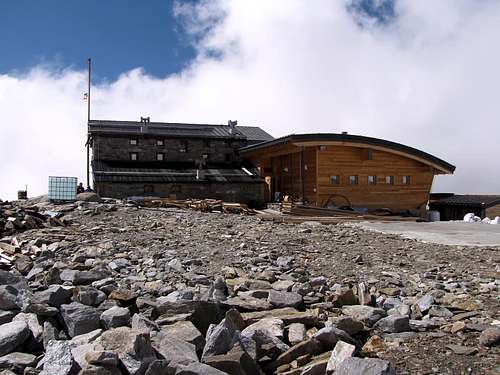
- Rifugio Città di Mantova m. 3470
Situation: Garstelet Glacier
Open: from June to September
Size: 85 persons + 15 in the winter-shelter
Guardian: Guide di Gressoney
Hut's phone : 0039 0163 78150 / 347 0802910 Email: info@rifugiomantova.it
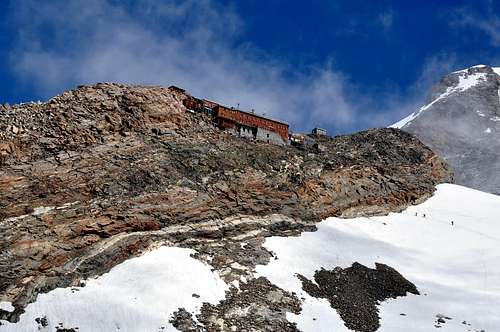
- Capanna Gnifetti m. 3611
Situation: Garstelet Glacier
Open: spring from middle March to middle May - summer from middle June to middle September
Size: 176 persons + 4 in the winter-shelter
Hut's phone : 0163 78150 / 347 0802910 Email: info@rifugimonterosa.it
When to climb
Best months are June, July, August and September. Ski-mountaineering: from the end of March to the end of May
Meteo
Meteo Valle d'Aosta
Meteo Piemonte
Guidebooks
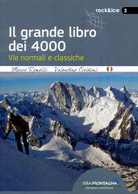
"Il grande libro dei 4000 - Vie normali e classiche" by Marco Romelli, Valentino Cividini - Idea Montagna Editore, 2015
“Tutti i 4000 – L’aria sottile dell’alta quota” – Club 4000, CAI Torino – Vivalda Editori
“4000 delle Alpi” by Richard Goedeke - Ed. Libris
“Monte Rosa” by Gino Buscaini - Guida dei Monti d'Italia C.A.I.-T.C.I.
|
|
|
|
Maps
"Breuil/Cervinia-Zermatt" Kompass map 1:50.000.
"Cervino-Matterhorn e Monte Rosa" n. 5 - Istituto Geografico Centrale map 1:50.000