
-
 20602 Hits
-
 92.04% Score
-
 37 Votes
|
|
Mountain/Rock |
|---|---|
|
|
39.01800°N / 106.3946°W |
|
|
13461 ft / 4103 m |
|
|
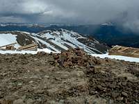
Quail Mountain Overview


These western slopes are surprisingly steep, and the 900 vertical feet and 0.6 mile from Hope Pass had me stopping numerous times to catch my breath. For more information on this route, see the West Slopes Route page.
Interesting Factoids
At the summit, there are two old and decrepit cabins, which I assume are buildings from the mining era. This summit provides a splendid position amongst numerous high peaks of the Sawatch, and it is well worth the visit.
SP member jimmyjay gave me this interesting information: Quail Mountain came very close to becoming a ski resort. A base village and several lifts were proposed from the 9400' level to the 11800' level on the NE slope and with a north ridge potential of 4000' vertical - which would have made it one of the largest in the state (Snowmass hadn't surpassed the 4k mark yet). Millions were poured into it in the 1980s. What saved it was the snow study which showed that it received 1/2 the snow of nearby Copper and 1/3 the snow of nearby Vail.
Today, except for the decrepit cabins at the summit, the mountain is as pristine as ever. Mountain goats abound on these slopes, and mule deer and elk aplenty are just below, in the valleys. Ptarmigan (and quail???) are also prevalant in this area.
Getting There

At 9.3 miles west, you will pass two large beaver ponds. This one is right next to the road. There is a small turn in the road here, and on the north side of the road a 4-wheel drive road turns uphill. There is a small post at the junction of this road, but no sign.
Park at the junction, or, if you have a 4WD you can continue up the 4WD road for 0.2 mile to the Hope Pass Trailhead. This is your starting point.
From the North: The Willis Gulch Trailhead can be accessed from Colorado 82, 8.4 miles west of U.S. 24 and 15.3 miles east of Independence Pass. To get to the TH, turn south onto a dirt road and follow it 100 yards. There is plenty of parking here.
TRAILHEAD CHANGE: Per harrise (7/4/2011), The Parry Peak Campground has signage at the end of saying the trailhead is located 1/4 mile east on HWY 82. There are two dirt pull offs that fit maybe six cars each. Just under these is the bridge across Lake Creek taking you to the trails.
All distances per Gerry Roach.
Red Tape & Other Considerations
For a ten-day forecast and current conditions of the Twin Lakes area, directly from the NOAA web site, Click Here. Remember weather conditions can change rapidly above timberline. Always be prepared!
Scott - May 15, 2005 9:00 pm - Voted 10/10
Untitled CommentHi Brad.
Below is a link to the weather forecast by coordinates for the mountain itself. Since it rounds coordinates to the nearest hundreth, it doen't get the exact elevation of the summit, but gets close. For mountain areas, I have found this forecast more accurate than the ones from the nearest town search on weather.com. Th current conditions are sometimes far away from the forecast area though, and current temps don't match the summits.
Forecast for Quail Mountain