
-
 6527 Hits
-
 90.81% Score
-
 33 Votes
|
|
Mountain/Rock |
|---|---|
|
|
38.40670°N / 111.04523°W |
|
|
Scrambling |
|
|
Spring, Fall, Winter |
|
|
5434 ft / 1656 m |
|
|

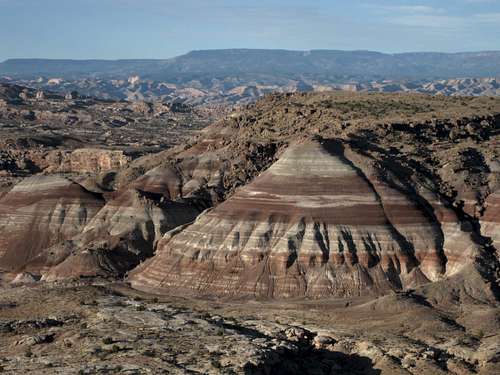
Anyone who loves colorful badlands, ridge rambles, desert scenery, and solitude will want to pay homage to this monarch.
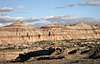
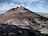
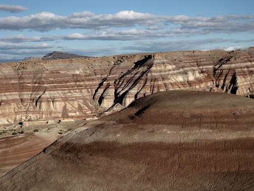
Queen of the Wash is an exceptionally large, exceptionally colorful bentonite peak in an area that itself is exceptionally beautiful. From certain perspectives, the Queen looks like a perfect pyramid. In actuality, it is just one of several peaks of a v-shaped (upside-down, that is) ridge complex consisting of Brushy Basin shale, and not even one of the three highest. The highpoint of the ridge complex is about a mile north of the Queen's summit, and this page covers it as well.
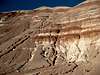
Climbing Queen of the Wash and the ridge highpoint does not entail a lot of distance or elevation gain, and it is not technically difficult if one chooses his route(s) wisely, but the climb can be a dangerous one. Any route up or down the peak is going to be extremely steep-- we are talking about 350' of elevation change in just 0.2 mi in some places (that is a grade of 1750' per mile)-- on extremely loose surfaces, meaning that a tumble could easily turn into an uncontrolled fall resulting in serious injury or death. There are several cliff bands, especially as one heads farther north, making route-finding more difficult, especially from above, and travel more dangerous, for added to the already-bad possible outcomes of an uncontrolled fall is the chance of rolling off the edge of a cliff.
You are not going to find Queen of the Wash on topo maps; it is an unofficial name, and I have only seen it in guides for the Cathedral Valley Loop in Capitol Reef National Park. But the formation, once you have read a description, is unmistakable, and the pictures and map on this page should make it only more unmistakable.
Don't even think of trying this peak in wet conditions or if it has rained recently. Chances are, you won't even be able to get there, but if you do, you will find yourself hiking through a gumbo that may suck the shoes from your feet.

Getting There
9.5 miles east of the boundary of Capitol Reef National Park, turn north off Utah 24 and onto signed Caineville Road. This road is dirt, sand, and clay. It is passable to most vehicles in dry conditions, but when wet it can become a greasy morass that not even 4wd vehicles can negotiate. Enjoy the very scenic drive through colorful bentonite badlands; at dawn, the scenery hues are amazing.
6.5 miles from Utah 24, you pass a wooden signpost marked "20." This is the stop on the Cathedral Valley Loop Tour that overlooks Queen of the Wash. However, you want to drive about 8 miles from 24 before parking (park on the highest ground possible). Anywhere between 8 and 8.5 miles is good. The best place to park is a short, rugged spur (only 0.1 mi at most) at 8. mi; the spur climbs a bench overlooking the peak and circles around to retrace the route to the main road.
Route Information

Distance: It's only about 0.8 mi to the summit of Queen of the Wash, and it can probably be a little shorter than that if you're willing to take on the loose, near-vertical faces closer to the road. It seems a shame not to go on to the ridge highpoint, though, and if you do that, you're looking at a round-trip distance of around 3.5 mi.
Elevation Gain: To the summit of Queen of the Wash only, the gain is about 400'. All the way to the ridge highpoint (5660') makes it about 700'.
Difficulty: Technically, this is all Class 2 by the easiest ways, but the dirt is so soft and loose that purchase can be difficult and you often have to use your hands to dig in in order to stop a slide. My descent route from the ridge highpoint did involve some Class 3 scrambling, and there was a little easy scrambling on the traverse near the northern end.
Notes: There really is no one best way up or down. Photos on this page show routes I used. In general, I found it easier to use the gullies on the peaks as much as possible because the surfaces there were harder-packed and there were more rocks for grabbing and for planting feet on.
On the way back, I worked cross-country to gain the large wash below the eastern face of the ridge, and then it was easy walking just about the whole way back.
You're not going to get lost out here, but if you want to ensure being able to retrace your route back to where you parked, consider building cairns (and dismantling them as you head back).
Ridge Complex
Seen from south to north:
 |
 |
 |
Approach, Ascent, Descent, and Return
Photos shown in sequence.
 |
 |
 |
 |
 |
 |
 |
Traverse
Photos are in sequence from Queen of the Wash's summit to the ridge highpoint.
 |
 |
 |
 |
 |
 |
 |
 |
Views

Red Tape
BLM land-- no fees or permits are required.
Avoid walking on the biological crust out here; it is alive and is critical to the desert ecology, and it is fragile. If the soil looks lumpy, dark, or crusty, avoid it. Better yet, try to stay on exposed rock and in sandy washes as much as you can.
Camping
No developed or primitive campgrounds are nearby, but dispersed camping is widely available. Don't camp on low ground, especially in washes, and don't camp on the biological crust. If you're driving the Cathedral Valley loop, you can stay at a primitive campground about 23 miles farther along the tour.