
-
 24944 Hits
-
 94.87% Score
-
 50 Votes
|
|
Area/Range |
|---|---|
|
|
38.49032°N / 111.35329°W |
|
|
Hiking, Trad Climbing, Scrambling |
|
|
Spring, Summer, Fall, Winter |
|
|
6924 ft / 2110 m |
|
|

Needle Mountain
Overview
Southern Utah is a realm of superlatives, but even in such a phenomenal display of hue and form, there are some places that stand out even more. The other places are not any lesser for it; it is just that the "special" places are not just remarkable but rather exceptionally remarkable. Cathedral Valley, perfectly named, is one such place.
The name alone is enough to inspire a visit. A description of the setting does even more. And a good photograph just might break the heart of someone who wants to go but can't.
A Love Born and Realized
So it was for me the first time I visited Capitol Reef National Park. Actually, the second time. The first time was in April 1996, but my brother and I just drove through on our way from Bryce Canyon National Park to Natural Bridges National Monument. We only stopped to take a picture of the sign at the park boundary. Yeah, once I was that way.
So it was July 1996, and I was back, this time with my girlfriend (now wife). We actually stopped this time, and as I looked over the park brochure, I saw a picture of Cathedral Valley. Right then, I knew I had to go there, but as I looked at the map and realized I had neither the time nor the vehicle to get there that day, I felt crushed. But I was back the next spring, armed with high clearance and more time, and that marked the first of my four visits now to Cathedral Valley. It is one of my favorite places in the world.
The Valley of the Cathedrals
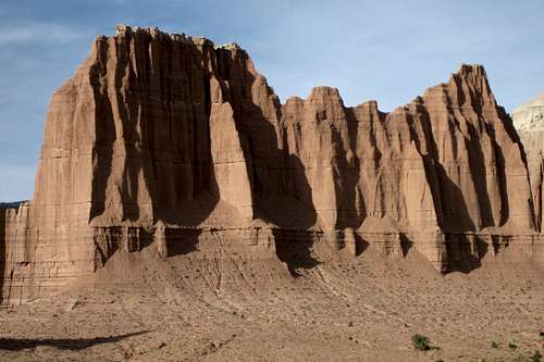
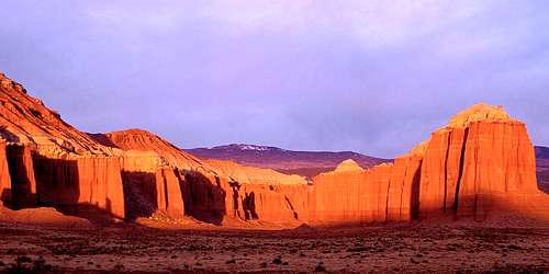
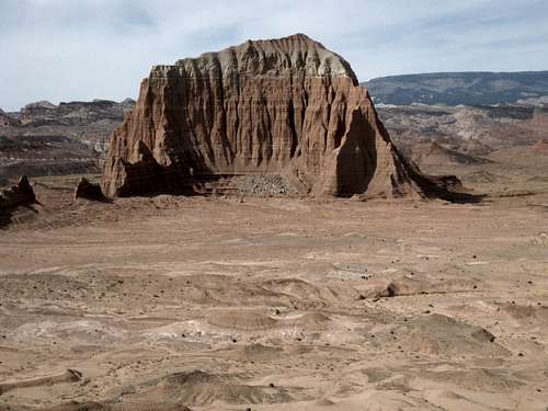
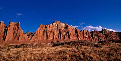
Hidden away in the northern part of the park and accessible only by long drives on dirt roads, the location itself is not only aptly named but also even more spectacular than the name suggests. Colorful sandstone monoliths tower hundreds of feet up into the deep blue Utah sky. Remnants of ancient ridges, these eroded spires now stand in silent splendor like sentinels. A few-- Temple of the Sun, Temple of the Moon, Cathedral Mountain (at 6924', the highest peak in Cathedral Valley), Needle Mountain-- have names, but most do not. Many of the cathedrals have never been climbed. Others have surely seen no more than a few ascents. Two-- the Temples of the Sun and Moon-- are closed to climbing to protect them from human-caused damage.
Golden eagles soar among the sheer cliffs. The wind is a constant and almost like a living force. Fragile wildflowers bloom in the sands and the delicate soils.
This is remote desert wilderness. Although dirt roads penetrate the heart of the complex, visitation is light, most likely because of the great distance from paved roads and the risks being in such places entails. It is country for wandering, for exploring, for escaping, and for dreaming. Sometimes harsh, it nevertheless casts a spell that those struck are happy to have felt. And they never really break free of it, not that they really try.
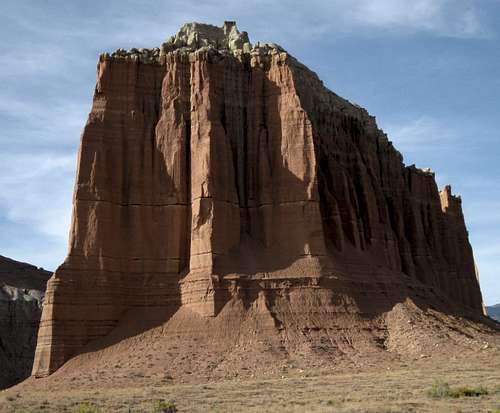
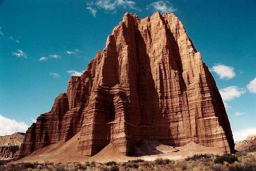
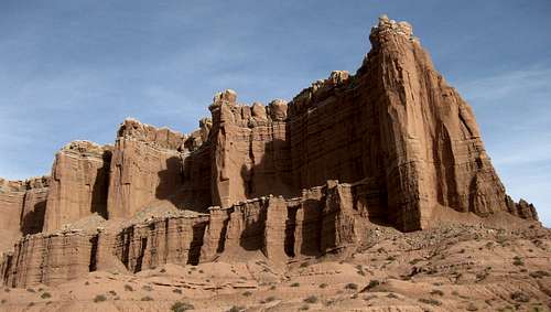
 Cathedral Mountain
Geology
On my pages, I usually devote little detail to geology and human history, preferring to focus instead on why a place is worth visiting, how to find it, and how to enjoy it. However, a place like Cathedral Valley almost forces one to ask "How did the Cathedrals get there?"True to form, I will not go into painstaking detail, but I hope the following will satisfy the merely curious:
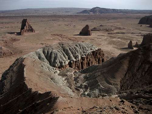
The free-standing formations, composed mostly of Entrada sandstone, are actually the remnants of a now-eroded, once-level (for the most part) plateau. Softer rock wore away, but the harder rock remained behind as the towers we see there today. From the valley floor, this may not be so apparent, but from Upper Cathedral Valley Overlook (see Tour section below), the "mountaintops" appear almost level with one another, and it is then easy to grasp the geological story here.
 Walls of Jericho
Getting There
There are three main access points for Cathedral Valley. I will provide more details about distances and important locations in the "Tour" section, but here is how to get to them:River Ford-- 2.7 miles east of the park boundary, turn off Utah 24 onto a dirt road that reaches the Fremont River in less than half a mile. You need high clearance for this crossing, and you should always check the water levels first. This road, Hartnet Road, leads about 33 miles to Cathedral Valley Junction in Upper Cathedral Valley, passing several scenic overlooks along the way.
Caineville Road-- 9.5 miles east of the park boundary, turn off Utah 24 onto a signed dirt road. This road leads about 26 miles to Cathedral Valley Junction in Upper Cathedral Valley, passing Lower Cathedral Valley along the way.
Last Chance Road-- Exit I-70 at Exit 91. Follow the main trunk road almost 27 miles, first east a few miles and then mostly due south, to Cathedral Valley Junction. Signage is not good along this route, and although the way is almost intuitive, there are some potentially confusing junctions, and a good road map will come in handy. I found the DeLorme Utah Atlas and Gazetteer very useful.
 Upper Cathedral Valley-- by CEHogge
A Tour of Cathedral Valley
Many people who visit Cathedral Valley enjoy doing so via a loop of almost 60 miles that begins at either River Ford or Caineville and ends at the other. It is better to start at River Ford rather than risk finding the river crossing unmanageable at the end of the day, and I will describe the loop from that direction.You can find more details about the loop from the GORP Cathedral Valley Loop Tour; my description will cover what I consider to be the highlights.
All these roads are dirt, sand, and clay as well and should also be avoided in wet or potentially wet conditions. The climb from Upper Cathedral Valley to the plateau is rough and steep in places but not difficult.
Before venturing out into this remote area, please read the Precautions section on this page and prepare yourself accordingly.
The Loop
River Ford-- This is sometimes little more than ankle-deep, but I have had to cross it in knee-deep water, and I know it can be higher after storms and during spring runoff. There supposedly are two crossing places a few hundred feet apart, but I have never seen a second one. The stream is wide here, but the bed is rocky and mud is not usually an issue; nevertheless, if you try to cross without high clearance and four-wheel drive, you are asking for trouble, such as a flooded and stalled engine mid-stream, or a displaced vehicle. River Ford
Exactly what is bentonite?
From the source linked above--
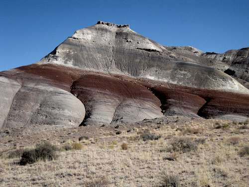
"Softly contoured and banded in shades of brownish-red, grayish-green, blue and purple, these rainbow hills resemble the Painted Desert of Arizona and the Badlands of South Dakota. They are similar, also, to the colorful Chinle slopes of Capitol Reef and the Circle Cliffs. However, they are not of the same geological age as those features. These colorful mounds are known variously as the Bentonite, Rainbow, or Painted Hills. They are encountered not only along the River Ford-Hartnet Road but on the Caineville-Middle Desert access road as well. They are among the most visually flamboyant features of the region.
The Bentonite Hills appear to be rounded masses of clay. Actually, they are formed of layers of soft stone of various colors, the surface of which turns to clay when exposed to weathering. What is seen by the eye is a veneer of color-banded, popcorn-like clay, which obscures the basic rock layers beneath the surface. When wet, the clay absorbs water and becomes gummy and very slippery, making vehicle or foot travel difficult or even impossible: hence the warning to avoid areas of clay when wet or when rain or snow threaten.
Technically, the Bentonite Hills are the Brushy Basin shale member (component) of the Morrison Formation (group of rocks). The Brushy Basin shale was formed by mud, silt, fine sand, and volcanic ash, laid down in swamps and lakes about 140 million years ago during Jurassic times. It contains a measure of bentonite, a useful clay consisting of aluminum and other minerals. The impure bentonite of this area has not proven commercially attractive. Also found in the Brushy Basin shale are dinosaur bones and petrified wood."
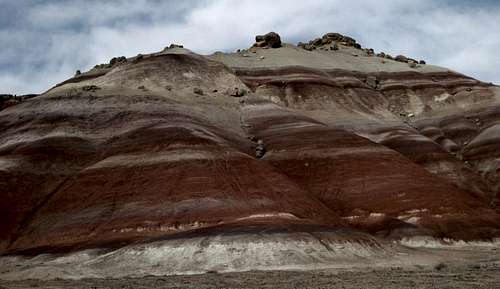 Bentonite Hills
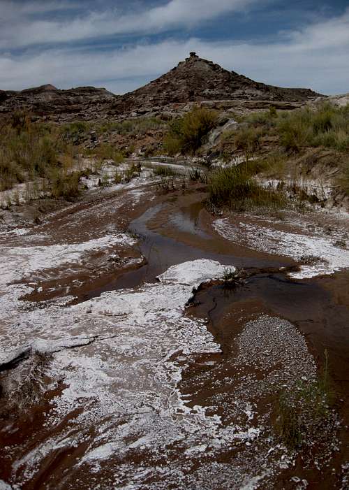 Rockwater Spring
About a mile before the turnoff, look on the right for a narrow 4wd road. This road ultimately connects to Caineveille Road, but it also provides quick access to Rockwater Spring, a salty flow that includes a small waterfall in a sandstone bowl. If you are concerned about your paint job, don't venture onto this road, for you will scrape tree and shrub branches as you go.
 Jailhouse Rock from Lower South Desert Overlook
Lower Cathedral Valley Overlook-- 17.6 miles from the highway, stop at a small parking area and signed trailhead to enjoy a short hike (or easy scramble) with views of Lower Cathedral Valley that few people ever see. A route page attached to this one provides pictures and more details.
 Lower Cathedral Valley Overlook
Upper South Desert Overlook-- This turnoff is 27 miles from River Ford. Enjoy the views from the parking area or hike up a small knoll for better views of the desert and the Waterpocket Fold. At this point, you are nearly 2000' higher than you were at River Ford.
Upper Cathedral Valley Overlook-- The short spur to this location leaves Hartnet Road at 27.3 miles from River Ford. A short hike leads to spectacular views of the formations of Upper Cathedral Valley.
Hartnet Junction and Upper Cathedral Valley-- You are now 27.5 miles from River Ford. Go left to leave the loop and reach Thousand Lake Mountain; go right to continue the loop.
From here, the road descends into Upper Cathedral Valley. The descent is steep and rocky in places and is the roughest stretch of the loop, but there usually are not major obstacles, and four-wheel drive is not necessary in dry conditions.
Upper Cathedral Valley has several spires and large cliffs all composed of the same colorful rock. The two highest formations, Needle Mountain and Cathedral Mountain, rise as much as 500' from the desert floor; the former is right next to the road, and the latter, the higher of the two and the highest peak in Cathedral Valley, is a short distance west. As the road swings east to Cathedral Valley Junction, it passes a long east-west cliff called the Walls of Jericho (because of visible crumbling), also called Wall Street (because of a supposed resemblance to the skyscrapers of Manhattan, not because it is protected by public money, though that is true, too). Seen from the east, the formation reminds some of a dome-capped basilica, which perhaps inspired or reinforced the name
Cathedral Valley.
Look for the Cathedrals Trail (mentioned in the next section) where the road runs north-south directly west of Cathedral Mountain.
 Walls of Jericho-- by CEHogge
Gypsum Sinkhole-- Now you are 33 miles along the route. Turn right onto a marked spur and drive a short distance to the sinkhole, which was formed when the land collapsed after dissolved and drained gypsum left it weak (people used to think a meteorite had caused the crater). The sinkhole, about 50' in diameter, has sheer or overhanging edges and is more than 200' deep, so be careful when checking it out. Exploration is not allowed unless you have obtained an NPS permit to do so, for this site is located within Capitol Reef National Park.
Back on the main road, about five miles past the turnoff, you pass a long, colorful, eroded cliff called Layercake Wall.
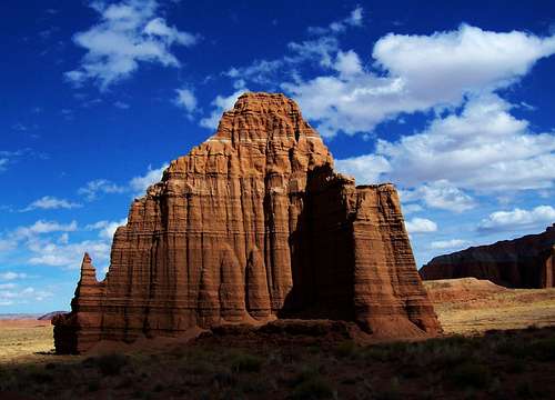
Lower Cathedral Valley and Glass Mountain-- The majority of pictures people see of Cathedral Valley seem to come from this location, and the majority of those seem to be of the massive Temple of the Sun, the Temple of the Moon, or both. This location is also within the boundaries of the national park.
 Temple of the Sun
Climbing the Temple of the Sun and the Temple of the Moon is prohibited.
 Temple of the Moon-- photo by gjagiels
If you do not have a high-clearance vehicle but want to see Cathedral Valley, you can make the trip to Lower Cathedral Valley in most passenger cars via Caineville Road in dry conditions. I say this because I have done it myself.
Beyond Lower Cathedral Valley, you soon leave Capitol Reef National Park for good and head toward Wood Bench and into the Middle Desert.
Bentonite Hills-- Again! At 48 miles, the road abruptly leaves the open desert and snakes its way into and through bentonite badlands like those at the beginning of the journey. You stay among these bentonite hills the rest of the way. The road becomes narrower and a little rougher, but it still is "easy" in dry conditions.
 More bentonite hills
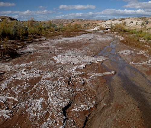 Willow Seep
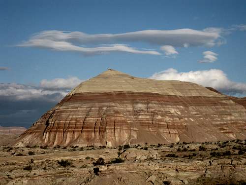 Queen of the Wash
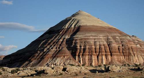 Queen of the Wash
Last Chance Country
Most visitors to Cathedral Valley use River Ford and/or Caineville Road, but those approaching from the north (see Getting There for directions) have the opportunity to drive through some of the loneliest road-accessible country in southern Utah. First, the 27-mile route between I-70 and Cathedral Valley Junction passes through high desert characterized by scrub vegetation. Next, it crosses the Last Chance Desert, where black volcanic boulders are scattered across the landscape. Finally, it passes by cliffs and towers like those in Cathedral Valley proper, giving a fine taste of what wonders are to come. Adventurous climbers may want to try Solomons Temple, a massive butte east of the road fairly close to Cathedral Valley. This peak is guarded by sheer cliffs on all sides.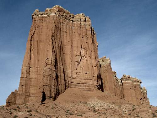 Last Chance Country
If you are driving from the interstate and planning to exit at River Ford, it is more important than ever to gas up as close to the interstate as you possibly can (the nearest town is a few miles west). It is 60 miles from point to point, and if the ford is impassable, you have to go back the way you came or drive back to Cathedral Valley Junction and then take Hartnet Road to Utah 24. Either way, since the closest gas station on 24 is still about 20 miles away, you are looking at a total drive of around 140 miles, and mileage like that can drink a lot of gas in dirt-road conditions.
 Last Chance Country
Activities
Most visitors simply drive the roads and get out at the overlooks to take pictures. But there is more to do than just that.In addition to what follows, there are mountain and route pages attached to this one. Not all of them are for destinations in Cathedral Valley proper, but all are destinations accessed from the roads in the area.
Hiking
Several of the overlooks and pullouts have short trails leading to better views. There are also three established routes.Lower South Desert Overlook-- From here, a trail leads to an overlook of South Desert and then down to the desert floor along an old road for a few miles past Jailhouse Rock and then Temple Rock.
Lower Cathedral Valley Overlook-- A short hike to one of two saddles, or a ridge traverse between both, leads to fine views of some of the area's most spectacular formations. A route page attached to this page provides pictures and more details.
Cathedrals Trail-- A trail (from a signed trailhead) goes for a mile past the highest formations of Upper Cathedral Valley.
Scrambling
Just about anywhere. There are so many ridges and outcrops out here just waiting for wanderers and scramblers to check them out.Rock Climbing
Technical climbing is not very good out here because the rock quality is poor (lots of brittle sandstone), but that does not mean the daring lack opportunities. The Temple of the Sun and the Temple of the Moon are closed to climbing, but the other formations are not. Rules to follow: no white chalk, no installing new bolts except to replace existing unsafe ones, no power drills.Precautions
You are in a remote area. Help is far away, and wet weather can turn the roads to gumbo and strand you. The roads are generally not challenging but do have rocky sections that can eat your tires.• Out here, you can be 30 miles from the nearest paved road; the nearest towns are even farther away. If your vehicle breaks down or weather conditions make the roads impassable, you can be looking at two or three days of walking to find help or two or three days of waiting for conditions to improve. Have enough food and water to last for at least two extra nights out. Although the route is not a busy one, you probably will see someone else out here, but don't count on it, especially in winter.
• Have at least one full-size spare tire.
• Have a basic tool kit and materials for repairing a flat tire.
• Have a full tank of gas. That seems obvious, but I'm saying it all the same.
• Spring and fall are the best times to visit. They tend to be the driest seasons, and temperatures are pleasant. Summers can be uncomfortably and even dangerously hot. Winters can be bitterly cold, but a bigger concern is being caught in a snowstorm; this is not a heavy-snow area most years, but it has its moments.
• Don't even think of coming out here if it has rained recently or if rain is likely. The roads will become a gooey grease impassable even to 4wd vehicles.
• If you do get into trouble and have to abandon your car, your best bet is probably to head to Utah 24, which gets a good amount of traffic, and then head east to Hanksville, about 20 miles from Caineville. Hanksville has motels, restaurants, and gas stations. Be aware that a walk to Hanksville could be up to 50 miles!
• Let someone know when you go and when you plan to return, and set a "Start worrying" time and plan.
• Avoid walking on the biological crust out here; it is alive and is critical to the desert ecology, and it is fragile. If the soil looks lumpy, dark, or crusty, avoid it. Better yet, try to stay on exposed rock and in sandy washes as much as you can.
Red Tape
No fees or permits required; consult the park website for general regulations.Camping
You can camp just about anywhere, but don't camp on the biological crust, and don't camp in washes and other low-lying areas lest you suddenly find yourself floating away during a storm.There is a primitive campground near the turnoff for Upper Cathedral Valley Overlook. No fee is required, and there is no water.
External Links
The following sites have good information about the park:NPS Capitol Reef site
Capitol.reef.national-park.com
Fred Spicker - May 16, 2014 6:41 pm - Voted 10/10
Caineville RoadIf the ford is not passable and you are looking for the Caineville Road, it can be easy to bypass at highway speeds since the road sign is quite small and the BLM sign is set far back. Slow down and start looking between mile posts 97 and 98. If you are going E and you get to the Rodeway Inn, you have gone too far. Going W - It is about 1/4 mi to the Caineville Road from the Inn. A short distance up Caineville Road, you will come to an unsigned fork - take the right fork.
Bob Sihler - May 20, 2014 6:08 pm - Hasn't voted
Re: Caineville RoadFred, these are good additions that I'll incorporate. I've been there several times and never thought of these things from that perspective when writing the page because I've long known exactly where to look. I should also add that the road starts immediately west of the long, obvious ridge known as North Caineville Reef.