Approaching Mt. Rainier National Park
![Mt. Hood]()
![Copper Creek Inn]()
![Packing Up]()
![The Park]()
![Lenticular Cap]()
![Ranger Station]()
![Nisqually Glacier]()
"It’s a hot one out there today boys,” Phil, my father-in-law, commented as we sped across the desert. “I thought Oregon was supposed to be green,” I dryly replied while watching some unidentifiable bird-of-prey circling off the side of the highway. “It is, just give it some more time,” was his response. Sure enough, as the highway dropped down into the Columbia-River basin, the amount of trees and vegetation increased dramatically. It was a welcome sight after looking at rolling brown desert for most of the drive. The river basin was filled with waterfalls, pine forests, and occasional views of Mt. Hood, my first glimpse of any mountain belonging to the Cascade Range. Every so often we would spot a bald eagle perched on top of a tree, gazing across the river, undoubtedly looking for its next meal. We finally reached Portland where we were to meet the 4th member of our team. Due to time constraints, he decided to fly that far and drive with us the rest of the way.
After picking Peter up at the airport, we began the final leg of our journey to Mt. Rainier National Park. We made a stop at a grocery store to get some breakfast for the next day, and more importantly, our “victory dance” for the summit (a block of cheese and stick of pepperoni.) After a few more miles on the highway we reached our exit and entered the countryside of central Washington. As we followed the road around rolling hills and small farms I noticed the countless timber-tracts criss-crossing the landscape, and marveled at how steep some of the terrain was that had been cleared. After a while we reached Morton, a small logging community, and asked around trying to find a good place to eat. We were told to hold out until we got to Ashford, so we piled back into the car and kept going.
The countryside quickly turned to thickly-vegetated forest. I couldn’t believe that about 30 feet into the woods it looked as dark as night despite being only 5 o’clock in the evening. I felt confident that if Bigfoot really does exist, he is living in the gnarly woods of central Washington. Every so often the hills would open up for a second and we would catch a view of Mt. Rainier, and I would stare at it in astonishment. Even from this distance I could see the gnarly gaping crevasses in some of the ice flows, an image that would keep flashing in my mind the rest of the evening.
We finally reached a gear/souvenir-shop/restaurant and decided to get out and see if this was the place for our final meal. We wandered around admiring the impressive selection of equipment and found a few souvenirs; however, I realized that a Mt. Rainier T-Shirt wouldn’t be as cool if our summit attempt was unsuccessful, and not wanting to jinx our climb I decided to hold out. While in the store we overheard some people talking about the Copper Creek Inn having really good food, and as it was just down the road, we piled into the car again and kept going.
The people in the store were right. The food was phenomenal, and I highly recommend the Paradise Burger for anyone that decides to give this place a try. We sat talking about various logistics pertaining to the climb as we ate and made plans for the morning of our summit attempt. We bought an entire blackberry pie for the road, and devoured most of it upon arriving at our spot in the Cougar Rock campground. I slept in the bed of the pickup truck, which was surprisingly comfortable, and looked through the trees into the sky as I tried to fall asleep.
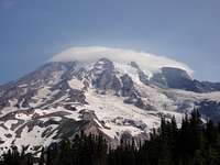
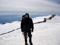
Being worn out from the 13-hour drive, I slept well and felt good upon waking up in the morning. We sat around eating cereal and the remnants of the blackberry pie, stringently loading our packs trying to keep the weight down. Feeling confident that we hadn’t forgotten anything, we put everything into the truck and began winding our way up to the Paradise Ranger Station. This drive afforded us our first lasting views of Mt. Rainier. There was a thin lenticular cloud hugging the summit which we hoped was coincidental and not an indication of bad weather to come. We parked at the ranger station then went in to buy our climbing permits and check the weather one last time. The ranger told us that we could expect good weather today, with conditions getting worse the afternoon of our summit attempt. We were hoping to be on our way down the Muir snow field at that point, and were not overly concerned about the forecast. Upon filling out all of the necessary paperwork, we retreated to the truck to get our gear and hit the trail.
Paradise to Camp Muir
![Starting on the Trail]()
![Crew of Climbers]()
![Oasis of Trees and Flowers]()
![Looking up the Snow Field]()
![Ridge]()
![Crevasses]()
![Looking Down Towards Paradise from Camp Muir]()
![Huts]()
![Camp on the Cowlitz Glacier]()
![Camp]()
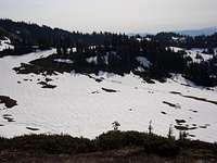
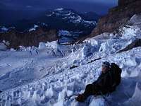
The trail starts right next to the guide hut just across from the Paradise Inn. It is pavement for the first few hundred yards, then turns into hard-packed dirt the rest of the way. There is a sign at the bottom indicating that it is 4.4 miles to Camp Muir. It was a warm sunny day and the sunburn conditions were optimal. I decided to make a homemade hat/bandana combo to protect my neck and ears from the sun, and wore some vintage Julbo glacier glasses to protect my eyes. The path was well marked and there were a number of people working up the trail with us. The trail periodically passed through an oasis of pine trees and wildflowers breaking up the monotony of the snow, but it would always return to snow before long. I kept looking up and to the left at the Nisqually glacier, a gauntlet of gaping crevasses and huge seracs. We eventually had to climb a ridge that had been running parallel with the trail for quite some time, and slowly began working up the switchbacks to the top. The view from the ridge was rewarding. It felt good to have some elevation gain under our belt, even if it was minimal in comparison to the 8000+ vertical feet we had yet to climb. There was a small glacial stream that we had to cross, and we decided to stop and have lunch after crossing it. I pounded a cliff bar and an apple and took a few swigs of water as my fellow climbers enjoyed a similar meal.
We spotted a number of larger teams following our lead and as the distance between us closed, we decided it was time to hit the trail again. The changing scenery and vegetation of the lower mountain drastically transformed into an abyss of blinding snow as we left the beaten bath and started on the boot path towards Camp Muir. We slipped into a rhythm and pounded on the trail for a while before stopping for some water. I kept thinking about the irony of being surrounded by frozen water, but yet the heat, radiation, and UV rays were intensified by it and were sucking the moisture out of my body.
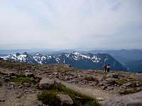
The snow field kept going and we kept climbing. Other mountains in the Cascades became visible as we gained more and more elevation. The air quality was good and allowed us to see some of the peaks that were further on the horizon. Finally, the stone huts came into view, but we were fooled into thinking they were closer than they actually were. It still took us quite a while before we were standing on the ridge at just over 10,000 feet.
Camp Muir was a frenzy of activity. Everywhere I looked something was going on. Climbers were setting up tents, boiling water, checking gear, eating, practicing with ropes, etc. It reminded us of how much we still had to do before climbing into our bags for the night. There was a rope separating the rock from the snow on the other side. It read something to the effect of, “Hidden Crevasses, Rope Up Beyond This Point.” After reading it I looked beyond the rope to see a number of people were camping there. I felt confident that my team surely wouldn’t set up camp in such a hazardous area until I realized that they had already walked over there and had even picked out a spot.
After getting our tents set up we began the usual chores of melting water, cooking dinner, and collecting snow. My appetite was out of whack and I struggled to finish my dinner. I pawned the rest of it off to my teammates and began getting my sleeping bag out. The sun set behind the cliffs at about the same time that we finished filling our bottles with melted snow. We talked for a few minutes, set our alarms, and retreated into our bags for what Phil would promise to be one of the worst nights ever. He was right. The sun had set, but it was still light out, and the yellow Mountain Hardware cover on the tent amplified the light dramatically. I felt like I was trying to fall asleep in the middle of Christmas tree. I continually tossed and turned trying to get comfortable, and every time that I did, I would realize that I needed to go to the bathroom and would get up to go.
Finally it got darker and I started drifting off when suddenly, “Hey, Reggie! Get Over Here! You are going to be 3rd on the rope! Lisa, You are Second!...” I jerked upright into a sitting position trying to figure out what was going on. I looked at my watch and it was 10:02PM. Who are these people?!, I thought. The guides and most everyone else in Camp were planning on a midnight wake-up call, and these people are leaving two hours earlier? My thoughts were interrupted by…”Tom, Shut Up, People are still sleeping!!!” What Reggie failed to realize is that he was yelling louder and making more noise than Tom was by telling him to shut up. Finally, the clinking of carabiners and crunching of crampons quieted as they departed from camp. Later I found out that some of my teammates in the tent next to us were about to practice self-arresting techniques on Reggie and Tom, but they had departed camp before they could get our boots on.
Camp Muir to Summit
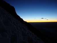
When I finally began dozing off again, the alarm snapped me back into reality. As I lay in my sleeping bag I could hear the clinking of tools and harnesses all around me. Periodically, the beam from a headlamp would sweep across the tent, momentarily lighting it up and allowing me to see Peter already up and getting ready. I followed and put on my various layers of clothing, then exited the tent. The weather was perfect. There was not a cloud in the sky or even a breeze to contend with. The groups around us would line up on the boot path next to our tents to get organized, and would trudge off starting the traverse across the Cowlitz glacier. By the time we left, there was a steady line of headlamps all the way to Cathedral Gap.
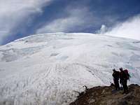
The Cowlitz glacier is fairly straightforward. There are a few crevasses that skirt the boot path, but the footing is solid and the angle is not steep at all. The primary concern is a rock fall area about the last 50m or so before reaching Cathedral Gap. There is little or no warning that a fall will occur, so the best tactic is to spend as little time as possible on that section. The glacier transitions into loose rock and skree and requires a number of short switchbacks to the top. Once on the top, the path traverses around the Cathedral rock formation and drops onto the Ingraham Glacier. The current boot path makes somewhat of an ‘n’ shape on the glacier as it parallels the Cathedral Rock formation, then cuts across at the base of a bunch of hanging seracs, then cuts back down a ways to get to the base of the Disappointment Cleaver (DC). On the Ingraham Glacier we crossed over a number of crevasses that were only a foot or so wide, and I would try and look down them as I passed over to see how deep they were. This long traverse up, across, and back down the Ingraham was in order to avoid a bunch of huge crevasses and holes in the glacier. We would stop periodically to have some water, but we wanted to keep pace with the majority of climbers ahead of us. There is yet another hazardous rock fall area before exiting the Ingraham and getting on the DC. Again, we hurried on that portion of the path and reached somewhat of a bottleneck of other climbers.
As we skirted around an exposed portion we ran into a team that was going off the path and onto some snow. We stood and waited as they discussed putting in some ice screws, and not realizing that they were indeed going off the trail, we waited and followed once they had climbed on. As we began the climb up the DC, we spotted first light on the horizon. I was amazed at how well my crampons held even on churning skree and loose rocks, and we slowly progressed up the ridge. We reached a patch of snow with some switchbacks, and I noticed the snow covered in sun cups. It would turn out that the snow conditions would be similar for the remainder of the climb, an added safety feature as this would prevent a fall from turning into a slide on steeper terrain.
After reaching the top of the switchbacks we decided to stop and take a break. We all broke out our down jackets and hunkered in for a rest. I think one or two of my teammates got to nap for a few minutes as I focused on eating and staying warm. From our resting area we could see the crevassed and rugged terrain of the Emmons glacier. It was a little disconcerting to see how much more elevation we needed to gain, and the sun was already up and on the horizon. We got back up and started pounding away on the trail again. Upon reaching the top of the DC we could see a team of climbers working across a long traverse to get onto the main portion of the Emmons. The trail passed just above some gaping crevasses and below a hanging serac. We pushed on and followed their lead on the trail.
The boot path was still very well marked, and the sun cups added a sense of security as the trail became steeper. The switchbacks continued as we trudged up the Emmons, the monotony broken up by a crevasse crossing or water break every so often. We passed a crevasse on the side of the boot path that was unbelievable. A slit in the snow opened up into being about 7 or 8 feet wide, and the inside walls were blue and perfect. I felt like I was looking into a flawless topaz-lined cave. We started coming across teams on their way down and would exchange pleasantries as we passed. The last 1000 feet or so the wind picked up and blew incessantly from that point on. We stopped to put on another layer, then started to grind away at it again. We kept hearing that we were almost there, but we still could not see well defined crater rocks of the summit. About 600 feet from the top we came to a split in the trail. There was a crevasse that had a 6-foot ladder across it, and there was a newly blazed trail that some guides had just created to avoid the latter. We opted for the new trail that did not require a ladder; however, after crossing it, I will not claim that it was any safer. The new boot path skirted an exposed ridge and was crossed by a number of crevasses. Knowing that this way had not been tested by a number of climbers before us made me uneasy, but we pressed on and luckily made it across without incident.
After that crossing we started to feel drained mentally and physically. Some clouds had begun developing around the mountain, and the sun was starting to warm up the snow. The last thing we wanted was bad weather moving in and warmed-up snow bridges on the way down. Luckily, after a few minutes we could finally see the crater rim. We slowly progressed up the last 600 feet of switchbacks and arrived at the summit. There was a team that had just traversed across the rim that was roping up to head down. By the time we got our packs off and broke out the cheese we had the crater to ourselves. After a break we traversed the crater rim and stood on top of the true summit. It was quite a relief to have made it with such favorable weather and climbing conditions. We took some pictures, and hurried back to our gear to begin the descent not wanting to press our luck on the melting glacial terrain.
From the Summit to the Bottom
The snow was slushy but still held well, and we returned over the dicey crevassed crossing without any problems. It was hard to believe how quickly we were able to drain elevation, and we caught up to a few groups that had passed us on their way down. On the way up I had not even seen the Ingraham Flats campground in the dark, but on the return trip it was interesting to see how many tents there were, and how close some climbers were camping to crevasses. Upon reaching Camp Muir we had run out of water. Luckily, a climber in front of us had a bottle to spare and we split it amongst ourselves.
As I got in the tent to pack up my gear I wanted nothing more than to climb inside of it and crash, but I knew it was time to get down, and we needed to fast as a thick layer of fog and churning clouds was visible down on the Muir snow field. The descent down to Paradise was a nightmare. The fog was thick, and I biffed it a number of times on patches of blue ice. We ended up on a different trail somehow, and kept passing landmarks that we didn’t recognize from the way up. I felt like I was wandering through an enchanted forest, and about every 100 yards we would reach a sign that said “Do not leave the trail, this is a protected wildflower area.” Of course there were no signs saying where we were or where the trail was taking us. There were a few occasions when I honestly thought that we were going to have to spend the night in the woods somewhere, but luckily we ended up in the right spot. This was a testament to me of how dangerous the Muir Snow Field really is. In blizzard or whiteout conditions it would be disastrous to try and find your way.
Luckily, we had some Gatorade waiting for us in the car, and we downed them before even getting into it. Our first stop was the Copper Creek Inn for some Paradise Burgers on me, a promise I made to the team if we had a successful summit day, and I knew all along that if I did have to buy, it really would be my pleasure.
Comments
No comments posted yet.