Late Season Fools on Liberty Ridge
I feel we lucked out at every turn on this mountain. We stood beneath melting serracs, crossed soft snow bridges, escaped avalanches, evaded rock falls, found alternate routes over the bergshrund, endured foul weather and foiled hoards of mice. We didn’t survive because we were wise or great mountaineers; we were just plain lucky. I have every respect for the formidable Mount Rainier. Why she let these late season fools walk away without a scratch is a mystery to me even to this day.
A Dreadful lower ridge
![The team]() From left, Steve, Dick, Marc
From left, Steve, Dick, Marc![Bivy site behind Thumb Rock]() Bivy behind Thumb Rock
Bivy behind Thumb Rock
It felt like it was hours that we were struggling up extremely loose and steep dry ground. I had expected Liberty Ridge to be frozen solid or at least to have hard snow on it. So where was all the snow and ice? For a while every step started a rock avalanche.
I was trying to stay a couple hundred feet in front but not in direct fall-line from my climbing partners, Steve and Dick. Whose idea was this anyway? I was asking myself. Well, doing Mt. Ranier was mine, doing Liberty Ridge was Steve’s, and Dick? He always came along, never said much, was predictably late, consistently disorganized, and always ended up shining on the climb.
I saw a rock about 2 x 3 feet in size. “That must be big enough to stand on and rest,” I thought to myself. I made my way to it and stood on it. “ Ah, that feels good.” It took only seconds before the rock started to move. I slid down a few feet with it and quickly fell to the side and stopped. The rock, however, didn’t. I yelled down, “Rock!” I couldn’t see Dick, but Steve looked up for a second and looked down again. I yelled, “BIG Rock, guys!” Steve disappeared too.
The rock avalanche was sizable and headed directly toward them. I looked in their direction and prayed. When the slide—more like a trundle—stopped, I yelled down, “Are you guys okay?”
“Yeah!” someone yelled back.
I thought to myself, “I could have killed my two best friends.”
The Approach
Two weeks later was the 4th of July long weekend. The three of us rushed to rent a car at the Seattle Airport and get under way. When we stopped at the ranger station to pick up a permit, we were warned that a storm was coming in three days. He also told us that they had rescued two climbers from Liberty ridge two days earlier. Apparently one of them had been hit on the face by a rock.
Dick said, “You know what that means, guys. We have to hurry!”
By 3:00 p.m. we were hiking up the trail. It didn’t take long before we could see the entire north face of Mt. Ranier and Liberty Ridge itself. A friend of mine who had done the route a month earlier had commented, “The first time you recognize Liberty Ridge you will want to turn around and go home. Don’t be discouraged. It’s not as steep as it appears.”
The approach to Carbon Glacier went pretty smoothly. We camped close to its edge and watched the sunset do its afternoon dance on the north face of Rainier. I’m not sure if I got any sleep that night; I couldn’t wait to get started early in the morning. If it had been up to me, we would have started pre-dawn before snowbridges got too soft to cross. Getting Dick and Steve out of their bags, however, was a challenge.
The Glacier
It took some coaxing and cajoling to get my buddies going.
Dick muttered, “This feels more like work than vacation.”
Carbon Glacier was fully sunlit when we came to the first seracs. They were leaning and melting like a faucet that was left on. This was when we made our next foolish mistake by filling our water bottles. I guess the mountain gods were on our side to keep the seracs from rolling on top of us and to keep the snow bridges from collapsing under our feet.
We made fast progress toward the base of Liberty Ridge with our eyes scanning for any snow gullies. None were to be found. The most solid rock section was a broken up steep step about forty feet in height.
I pointed, “That’s our route, but we can’t use a rope.” I was afraid a rock would break off and hit the rope, taking me down with it into the gaping mouth of a crevasse below.
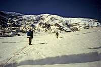
![Dick and Steve on the glacier]() Willis Wall looming above
Willis Wall looming aboveThe Ridge
![A rock step]() Rock Step
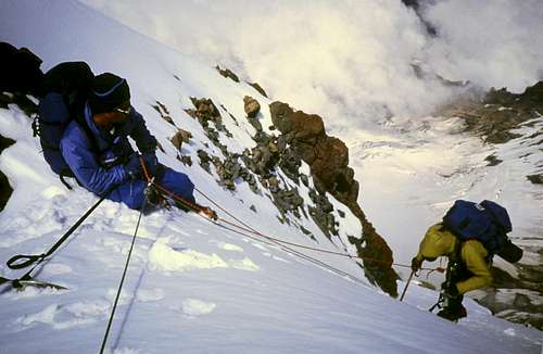
Rock Step![Thumb Rock]() Thumb Rock
Thumb RockThe rock step turned out to be easier than I had expected. I was the first to arrive on the ridge proper. Dick was next, but when he showed up on top, he was tied into one of our two ropes. He said he wanted to belay Steve.
“Okay, Steve. Climb!” Dick shouted down.
I started working my way further up the ridge. Within minutes I heard a loud crash! I yelled down, “Are you guys okay?”
Steve had pulled a large loose rock off the rocky section, but he was okay.
We moved carefully and methodically. I was praying for some snow and ice. I was tired of finding my way through steep and loose scree. A few hundred feet below Thumb Rock, our bivy site and objective for the day, I came across the first hard snow. I took out the rope, flaked it out on a rock, and quickly put on my crampons. By now Dick was there. I handed the rope to him and asked him to feed it out. In what seemed less than an hour, we were all on the base of Thumb Rock.
![Liberty Wall]() Liberty Wall
Liberty Wall Thumb Rock is a 300 foot formation made of broken volcanic rock. Just opposite of Thumb Rock there is another loose formation, and in between the two there is barely enough room for two small tents. Dick and Steve shared a very small tent; I had a tarp that could double up as a tent. During dinner we heard a loud crack. An avalanche plumetted down Liberty Wall only a few hundred feet away.
Around ten o’clock at night it rained for a short time. I worried obsessively that a rock would break off Thumb Rock and land on us. My fears came to be realized in the middle of the night when I heard another loud crack. It was a rock about a foot long that broke off the other formation and rolled to within feet of our bivy site. Sheer luck. I am predictably bad at getting sleep the first two nights in mountains. The rock fall didn’t make it any easier to get any shut eye. In any event, morning dawned and Dick, Steve and I had to get going. We had 4,000 feet of steep snow and ice to climb.
The Shooting Gallery
It had rained on us for a short time the night before. Rain at 10,000 feet? I thought to myself. This cannot be a very good sign.
In the morning one of the first things I noticed was hearing the sound of running water. By 8:00 a.m. it sounded like thousands of creeks running down Willis Wall to our left. Within a few hundred feet we came to what I called “The Shooting Gallery.” We had to go through a rocky formation that looked like a gun sight. Countless smaller rocks had come down the gun sight and scarred the steep slopes below. We scanned with our eyes for any possible alternate way to go up. None seemed any better.
![Above The Shooting Gallery]() Just above Shooting Gallery
Just above Shooting Gallery
Dick started to lead, heading straight up. Small avalanches of sand and pebbles poured unrelentingly down the middle of of the gun sight. Dick hadn’t reached the worst part yet when we saw some bigger pieces coming through the notch. One piece was noticeably larger than the rest. It missed Dick and came directly toward me. I didn’t want to jump out of the way until it got closer. I was tied with a 4-foot leash to my ice axe that was buried in the snow. I had to be sure which way to jump. By now the rock had picked up considerable speed and was tumbling down toward my legs. At the last second I jumped to my right. The rock hit my ice axe’s adze and bounced, missing me by two feet. “Let’s hurry up and go through this, guys!” I yelled.
Upper Ridge
Once we passed the Black Pyramid, we could not hear the running water anymore. The temperature dropped quickly and we put on extra layers of clothes. From this point on we did not see any more rock falls. The ridge seemed pretty consistent at 40-45 degrees with steeper sections peppered in mostly hard snow. Not much different from any other volcano: the higher you climb the less obvious the summit’s location. Still, we figured that as long as we were going up, we should be getting closer to the top.
I worried about the infamous bergshrund that I knew we had to overcome. But where was it? We finally reached a vertical section about 15 feet. No, this was not the shrund. There were no crevasses on either side, and it didn’t look like the photos I had seen. The three of us were tired. Progress slowed down considerably. And then I saw it: bergshrund ahead.
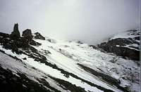
![Upper Willis Wall]() Upper Willis Wall
Upper Willis Wall![Storm?]() Approaching Storm
Approaching StormGetting Lucky
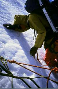
![Step]() Dick leading the first step
Dick leading the first step![Ptarmigan Ridge....]() Ptarmigan Ridge
Ptarmigan RidgeA gaping crack that seemed endless was a few hundred feet ahead. My eyes were panning to the right and left for the narrowest part of the bergshrund. Way to the left there seemed to be a section that I couldn’t make out. Hoping that it might be a bridge, I headed that way. The closer I got, the more promising the prospect. When we finally got close enough, I saw that a huge avalanche had covered part of the main bergshrund. I breathed a sigh of relief and told Dick who was just behind me, “That’s it, Dick!” We climbed on to the avalanche debris.
Summit Bivouac
![Melting snow]() Melting snow near the summit of Liberty Cap
Melting snow near the summit of Liberty CapThe sun was dropping down toward the horizon like a rock. We had just finished a long, very steep section of avalanche debris and the slope kicked back to about 40 degrees again. We were too busy to pay much attention to a sea of clouds that had begun to cover the entire landscape below our feet. Steve was tired and suggested that we dig a hole and stay there for the night. I objected to that strongly: if the storm actually hits, we needed to be closer to the top so we could head down the opposite side of the mountain. Liberty Ridge was too steep and dangerous to contemplate using it as an escape route. Dick agreed and got in front to lead another vertical step. Steve followed using his headlamp. Then it was my turn to climb. I asked Dick and Steve to turn off their headlamps so that I could climb with what little light was coming from the horizon. Then I was on top! Soon we were all on top of Liberty Ridge! The ground became nearly perfectly flat. We melted snow for drinking and made hot water bottles for our sleeping bags. There was little energy left for conversation after our long, hard day. There on top of the ridge we rested our beaten bodies for the night.
Summit of Liberty Cap, Mount Rainier, Descent down Emmons Glacier
![Liberty Cap Summit]() Summit of Liberty Cap. The dirt patch visible behind us is the summit of Mount Rainier.
Summit of Liberty Cap. The dirt patch visible behind us is the summit of Mount Rainier.![Summit of Mount Rainier in full condition]() Summit of Rainier in full condition
Summit of Rainier in full condition
When we crawled into our bags the night before we didn’t know exactly how far we were from the top. I was the first one out of my bag in the morning. Looking up I realized we were only a couple of hundred feet from the summit cone of Liberty Cap. Hurriedly I put on my crampons and grabbed my pack heading for the summit. Steve and Dick stuck their heads out of their tent and gave me dirty looks for being so chipper.
“See you on top, boys!” I shouted obnoxiously.
When I got to the top I realized that the entire mountain—except for the two summits—was socked in. It didn’t take long for Dick and Steve to show up on top. After taking a few summit shots, we proceeded to drop down about 400 feet to the saddle between the Liberty Cap and Columbia Crest. Another 800 feet of easy hiking put us all on top of Mount Rainier.
Getting Lucky again
By the time we reached the main summit of Mt. Rainier, the storm was upon us in its full fury. We scrambled to take a few summit photos, then turned to the task of descent.
Our original plan was to find Saint Elmo’s Pass which would lead us back to the north side of the mountain. But with the storm and cloud cover, we decided that finding the pass would be nearly impossible. Fortunately I had located a trail of footprints heading down toward the east side of the mountain. It would take us down to Emmons Glacier. We headed down. By the time we reached the treeline, darkness was upon us. We were forced to spend another night on the mountain. Although it rained most of the night, we were so tired that nothing kept us from sleeping—not even being attacked by hundreds of persistent mice trying to burrow into our sleeping bags with us.
In the morning we headed down the trail in an on-and-off rain. We ran into two climbers going up the mountain who were planning to approach Liberty Ridge via St. Elmo’s Pass. I told them about rain on our Thumb Rock bivouac sight, and the rock falls that had nearly finished me. Prudently they decided to cancel their climb and go back down with us. They also offered to take one of us to the north side parking lot to get our car. Steve volunteered to go. Lucky again, since we had no other way to get to our car parked 60 miles away.
Call me lucky; call me superstitious. I think Mount Rainier let us “Three Late Season Fools” off the hook too easily. Or, may be she was touched by the love we had for her.


Comments
Post a Comment