
-
 8272 Hits
-
 84.27% Score
-
 18 Votes
|
|
Mountain/Rock |
|---|---|
|
|
46.24997°N / 13.69652°E |
|
|
Hiking, Scrambling, Skiing |
|
|
Spring, Summer, Fall, Winter |
|
|
6276 ft / 1913 m |
|
|
Overview
 The south face
 From the N ridge
The south-eastern part of Krn group finishes with a steep, partly grassy, 500 meters high and some 2000 meters broad wall. The several peaks of this wall are guarding a gentle grassy slope, allmost a high plateau, lying north of them. The whole small group is inclined towards the east - from the high western ridge the slopes and valleys are falling down towards the east. First, as said, gently, later more steeply, all the way down to the valley of Tolminka river. If you would think that the relative low altitude of Rdeči rob and out of its northern ridge rising to Škofič, 20013 m, means an easy and quick ascent, you are wrong. The ascent from Tolminka river valley can last as long as up to 5 hours (1400 meters of altitude), the ascent from Kuhinja meadow above Krn village on the opposite side is some two hours shorter.
Rdeči rob is primarilly a hiker's goal. The tour is not difficult, but it requires some experience in a remote terrain. Especially nice is the tour in early summer, when the slopes around Rdeči rob are full of blossoming flowers. In winter, the ascent is also possible, even skiing from below the summit ridge. As for the summit name - it is clear that it can't be any other. In translation Rdeči rob means Red Edge. Just look on any of the pictures of this summit and you will see why. In the narrow area of Rdeči rob the white Dachstein limestone of Krn group disappears, being replaced by a red marly limestone from the late Cretaceous period (94-71 million years old).
Summit View
 South Bohinj Range
 Towards Triglav
From Rdeči rob the view towards the south is opened, interesting is also the view towards the east, along the Southern Bohinj range. On the NE, we see Triglav group, towards the north are the close-by higher summits of Krn group. Also towards the west the view is quite opened and fine.
Geographic Overview
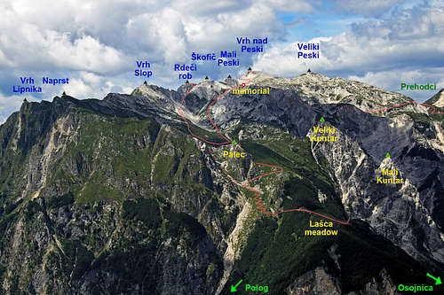
The eastern ridge of Rdeči rob is starting above planina Lašca (alpine meadow) with the first high summit, named Vrh Lipnika, 1688 m. Its northern neighbour is the sharp, stand-alon Palec (Thumb), 1612 m. From Vrh Lipnika the next higher bump towards the west in the ridge is Naprst, 1733 m, then Vrh Slop, 1827 m, comes after which the ridge culminates in the summit of Rdeči rob, 1913 m. There the ridge branches.
After a short summit wall of Rdeči rob, the SW branch goes over the summit of the close-by Veliki (Big) Stador, 1903 m, down to Mali (Small) Stador, 1731 m, after which the ridge lowers considerably and gets lost in the broad southern slopes of Krn massif. In lower regions the long, grassy southern ridge rather goes over Visoč vrh towards Mrzli vrh, both being already the fore-hills of Krn group.
The other branch goes from the summit of Rdeči rob towards the north. This north ridge - the first, short part of it, is actually the true 'Red edge' of our mountain. After the first notch it soon converts into a white limestone ridge and continues in the NW direction. The next summit of Škofič, 2013 m, would already be considered as a separate mountan in which we are here not interested any more.
Places of Interest
Besides a hiking interest a visitor can find in this area a few other items:
 Javorca
> Javorca memorial church. It was erected on a beautiful place above Tolminka valley, as a memorial to Austo-Hungarian soldiers who lost lives in fierce battles in this part of Krn group.
 Lašca meadow
> Beautiful alpine meadows. South of Rdeči rob (actually south of Mali Stador) the area of dreamy alpine pastures begins. The highest is planina Sleme, 1448 m, on the other side of Visoč vrh, 1483 m, there is planina Pretovč, 1140 m. On the eastern slopes of Visoč vrh there is a series of meadows, one more beautiful than another: Medrja, 1150 m, Laška seč, 975 m, Črča, 775 m, and finally a few houses of Javorca, 570 m. On the western side of Stador there is planina Leskovca, 1230 m, not to mention all others below Krn. And a special chapter is a more remote, but still alive planina Lašca, 1289 m, on the eastern side of Rdeči rob group. It lies on a dreamy beautiful terrace above Tolminka valley.
> Jezero v Lužnici, cca 1800 m. Krn group has only a few lakes. Jezero v Lužnici is a small one, but a nice place to stop by.
> Geological phaenomena. Close to the end of Tolminka valley there is a deep Pološka jama, a cave system in high mountain karst, which is not reachable for non-speleologists. An interesting phaenomenon are holes below the summit of Palec. They are supposed to be connected with the cave system of Pološka jama. In winter, warm air, coming out of these holes, melts a few meters thick snow cover. Above Tolminka there are also a few interesting boulders.
> Waterfalls. Although the southern part of Krn group is famous of many high and beautiful waterfalls, in the vicinity of Rdeči rob thera are not many. Only the creeks, flowing into Tolminka have a few not so high waterfalls. Interesting is also the source of Tolminka river.
> World War I remains. In WW1 the high summits of this part of Krn group were held by the Austro-Hungarian army. But the frontline was close, so you can still today see the remains from that time. Interesting is also the bunker system in Tolminka valley, being built after the WW1 by Italians who took over this territory.
Getting There
 In Tolminka valley
See the main Krn Group page and Julian Alps page to get an impression how to reach the towns of Tolmin and Kobarid!
1. The western, shorter approach on Rdeči rob starts in Krn village, 865 m. This picturesque mountain village can be reached by a mountai road, starting either in Kobarid or in Kamno, on the shore of Soča river. From there, we can drive further northwards, to the parking place before Planina Kuhinja (meadow), 991 m.
2. The eastern approach starts in Tolminka river valley. From Tolmin town we can drive by a narrow mountain road some 6 kilometers into the valley till Polog meadow, 457 m, below Javorca.
3. You might see on maps mountain roads up on meadows Pretovč and even Sleme. I'm not sure what is their formal status, but walking by them I can say that they are bad, steep and narrow, appropriate perhaps only for 4WD, with a praying not to meet another vehicle, coming in the opposite direstion.
Routes Overview
|
1. From Krn village, 865 m. Continue by the cart-road towards the NE till Leskovca meadow, 1230 m. from there on towards the east a more steep, but good path ascends. On the altitude of 1400 meters it hits the marked path from Sleme meadow. There turn left (towards the north) and ascend in many switchbacks through the valley between Mali Stador (on the right) and Leskovški vrh or Maselnik (on the left). In a small basin, on some 1700 meters, you will see a red inscription on the rock, directing you towards the east, up the slopes. From there you clearly see the red rocks of Rdeči rob and a steep, grassy ramp, ascending up the ridge. The path is not marked, it even gets lost in a steep grass, but in a good visibility you will not miss the passage and with some care reach the summit ridge. Then towards the right (south) on top. 3 hours, medium hard, partly not marked, steep hike-up. 2. From Tolminka valley over Lašca meadow. This is the most beautiful, but not the shortest and the easiest approach. As it is not marked, I described it on a separate page, here is only the outline: Polog, 458 m, planina pod Osojnico, 700 m, planina Lašca, 1289 m, around Palec, Mala rupa, 1600 m, north ridge, summit. 5 hours. Below shepherds path, above Lašca abandoned military paths, difficult to follow, below the summit ridge a steep, pathless slope. This ascent, together with the descent by route #3 makes a wonderful one-day round tour. If you are crossing the whole Krn group, you migh be coming also from other directions, for example from the summit of Krn (hut) over Batognica, or from Krn lake. But all these are not the 'natural' approaches to Rdeči rob. |
Of course, also the ascent by the whole eastern ridge, from Vrh Lipnika would be interesting. In the middle part this ridge can be reached from the north, but in the continuation towards Rdeči Rob a few sharp places are seen. Would be interesting to know more!
3. From Tolminka valley over planina Sleme.You start below Javorca, on some 500 m of altitude. By the church you continue by a cart-road towards the west. It goes through the forest along the Peščak creek, below you hear the noise of its waterfall. Above the waterfall the cart-road crosses the creek and soon you reach Črča meadow. Continue by the cart-road and the markled path towards the west. There are many shepherds paths, so take care to stick to the marked one. Marks are two-fold: red-yellow circular marks and red-black line marks, denoting 'Pot miru' - 'The Peace Trail'. So you cross also meadows of Laška seč and Medrja, from where you again continue by a cart-road towards the SW on Pretovč meadow. There turn right and hike up by the road on Sleme meadow. (From Medrja, you can also go directly on Sleme meadow - on the upper part of Medrja turn right and follow the trail, which goes east of Visoč vrh.) From Sleme meadow you continue by the marked path around Stador. East of Mali Stador you reach the crossroads with the path from Leskovca meadow and from there you continue on top, as described under #1. 4 h 30 min, until the final summit passage good, comfortable marked paths, the last part is a medium hard, not marked, steep hike-up.
Red Tape
No limitations. The area lies within the broader borders of Triglav National Parc.
Huts and Camping
There is a hut on Kuhinja alpine meadow, but it is only 30 minutes away from Krn village, which can be reached by car. The other mountain hut is on the summit of Krn, which is also not really supporting the ascent on Rdeči rob. So you do a one-day hike or rely on shepherds hospitality or take a sleeping bag and a tent and sleep in a 'thousand stars hotel'.
When to Climb?
The best months are early summer, when snow is gone and autumn. Summer can be very hot, especially on the east approach. In winter and spring most of the west ascent can be done with skis. It is possible to ski from just below the summit ridge down to Krn village. The passage on the summit ridge and on top is very steep, so in snow winter equipment (ice pick, crampons) is needed.