
-
 6528 Hits
-
 81.84% Score
-
 14 Votes
|
|
Mountain/Rock |
|---|---|
|
|
46.26395°N / 13.67721°E |
|
|
Hiking, Scrambling, Skiing |
|
|
Spring, Summer, Fall, Winter |
|
|
7139 ft / 2176 m |
|
|
Overview
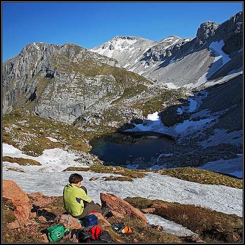
Above Jezero v Lužnici. Behind is Vrh nad Peski.


The name Vrh nad Peski means The Summit Above Sands. And it can not be more acurate. From anywhere you would go on our summit, everywhere you would have only rubble, screes, sands, debris,..., you name it. Those few rocks on top are only the remains, just to make you on the ascent a bit more careful.
The second highest summit of Krn group is getting far less attention than other vice-summits in Julian Alps. Of course Krn is very dominant and the group is small, but yet we can also with Vrh nad Peski find some good reasons to visit the area.
I would put on the first place the beautiful valley of Lužnica with its small lake. It belongs also to the other neighbouring summits, yes, but the natural highest point of the valley is Vrh nad Peski.
Secondly Vrh nad Peski can be very attractive in times of tour skiing. The slopes falling down towards Krnsko jezero (lake), so towards the north, are among the most beautiful ones for skiing in the group. And skiing can also be done towards the south.
On the third place, and let's leave the broad panorama aside, is the bloody history during the World War I. On the neighbouring plateau mountain Batognica the front line was stuck many months and even nowadays if you walk over the rubble slopes of Vrh nad Peski, pieces of iron will show up on almost every second step. Still today you can see concrete remains of a building on the very top of the mountain.
A Little of Geography
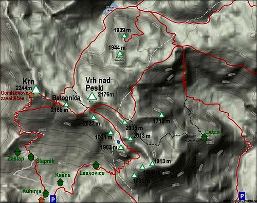

Jezero v Lužnici
The summit of Vrh nad Peski is rising above high valleys of Krn group, east of Krn, 2244 m, the highest summit. Between them there's also Batognica, 2165 m. SW of our summit there's a high saddle Prag, 2068 m, delimiting it from the ridge of Batognica. The summit ridge goes first towards the E on the nearby secondary bump, then it turns into the SE direction. Above the broad saddle there's first Peak 2035 m, on maps without a name, but often also dubbed as Mali Peski. It can be reached over its north slopes in easy climbing (UIAA I, only on top). After Peak 2035 m the ridge turns southwards, continuing on the neighbouring Škofič, 2013 m. This ridge is one of the most crumbly ridges in Julian Alps. They say that whatever you grab, you can take it home if you wish.
Parallel to this ridge, from Prag down towards the SE, the valley of Lužnica (or: Po Lužnici) stretches. In its lower part, west of Škofič, there's a small lake on 1801 m of altitude. It's some 40 meters in diameter and some 10 meters deep, of a nice blue colour. From the lake there are only a few steps on the notch between Maselnik, 1903 m, and Mali vrh, 1931 m. A tiny water stream frows from the lake towards the notch, but after only 10 meters it disappears in the karstic ground.
The whole northern and eastern side of the mountain is lowering steadilly down towards the big Krn lake, 1389 m, and Prehodci saddle, 1635 m.
Summit Panorama
All sides of a horizon are free, only towards the west there is the ridge going over Batognica on Krn. It's a nice scene too, fine is the plateau north of Krn, the Lužnica valley and in the distance the two different sceneries on the northern and southern side. The highest summits of Julian Alps on the north and the hilly landscape on the south.
 Towards Krn |
 Towards the SE |
 Towards Triglav |
Getting There
You can start the tour on Vrh nad Peski from many sides, some trailheads are more, others less remote.
1. From planina Kuhinja. The shortest approach comes from the parking place on planina Kuhinja (alpine meadow), 990 m, just above Krn village. You can reach the village and parking place from Soča valley, from Kobarid or Kamno.
2. From Tolminka valley. This approach is much longer. You can park there on planina (alpine meadow) Polog, 500 m.
3. The third valley to approach Vrh nad Peski is Lepena, a side valley of Soča valley. This is the approach from the north. In Lepena you can park on 700 m.
If you sleep in Gomiščkovo zavetišče, 2190 m, just below the summit of Krn, you go by the ridge and reach Vrh nad Peski in an hour and half.
Routes Overview
1. From planina (meadow) Kuhinja, 990 m

Maselnik

In Lužnica valley
Immediately above the parking place the cart road branches. While the left branch goes towards the mountain hut, we take the right branch which brings us in a few minutes on Kašna planina. There the road turns E and SE, ascends on a small grassy ridge which goes far down to Krn village, crosses the ridge and does another ascent towards the NE on planina Leskovica, 1230 m. There the cart road ends and we continue by a good, marked path in the eastern direction.
First, it crosses the slopes towards the SE (the shortcut goes more directly towards the E-NE) and on the altitude of 1400 m reaches a better marked path, coming from the right from planina Sleme. On the grassy slope we turn left and start crossing the slopes in the N direction. Soon the good path starts ascending the distinct valley in several turns. On the left are the steep rocky slopes of Maselnik, on the right of Mali and Veliki Stador. The scenery becomes more and more alpine and the valley more and more rocky. On 1700 m towards the right a marked path on Rdeči rob deters, but we keep straight, until the valley turns sharp left, towards the NW direction. Above one or two valley steps there's the saddle, 1858 m, between Maselnik on the SW and Škofič on the NE. Just on the other side of the saddle there is Jezero (lake) v Lužnici, 1801 m.
 |
 |
 |

In the upper Lužnica valley

Across the southern slope
From the saddle, the marked path crosses the slopes above the lake, on Škofič side. The upper valley is mostly rocky, only on its bottom there are grassy meadows. The marked path goes almost to Prag saddle, just below it we deter right by the path which crosses the southern slopes of Vrh nad Peski towards the east. The path would continue crossing the massif so when it approaches the E ridge of Vrh nad Peski we go straigth up, gain the ridge and continue by it towards the left (W direction again). Only the upper part has a few rocks which are easy to overcome. 3 h 30 min altogether.
2. From planina (meadow) Polog, 500 m
Due to rugged and hardly passable slopes west of the valley of Tolminka (Polog is its end) this is a very long tour. The direct marked path would go first towards the north on Prehodci pass, 1635 m. There is an important crossroads (was even more important in the World War I). We take the marked path left (towards the W-SW). Over the slopes of Malen, 1775 m, and by the broad edge of the high plateau the path finally brings us to the memorial pyramid on Mali Peski, 1975 m. There the path turns right, to the NW direction, ascends below the E ridge of Vrh nad Peski from where we go on top. Would be some 5 hours of ascent.
The second, shorter, but unmarked option would be over planina (meadow) Lašca. From the end of the valley we turn sharp left and ascend the alpine meadow on 1319 m, then we continue towards the west till the high basin below Rdeči rob. On 1750 m we take the W and then NW direction. The path crosses the slopes of Škofič and ascents directly to the memorial pyramid on Mali Peski. A bit shorter, but more difficult orientation. See also this route description: https://www.summitpost.org/rdeci-rob-over-lasca-meadow/332629!

The northen slopes
3. From Lepena
This is mostly a ski tour. In summer the upper part is pathless, unless we go much around on Krnska škrbina and over Batognica. We park by Dom (hut) Klementa Juga, 700 m. A good, marked path takes us towards the SE to Koča (hut) pri Krnskih jezerih, 1365 m. From there we continue towards the SW to Krnsko jezero (lake), 1389 m. We can get there of course also from other directions, for example from Komna. From the lake we continue in the SW direction to Planina na polju, 1543 m. There a steep valley towards the south opens. Above, the slopes get broader and broader and bring us on the eastern ridge of Vrh nad Peski. Some passages are steep for ski ascent. 4 h 30 min altogether.
4. From the summit of Krn

If you come on Vrh nad Peski from the W, you will obviuosly first cross the distinct Krnska škrbina (notch), 2058 m, between Krn and Batognica. The notch can be also reached from the S and N. The ascent from the notch on Batognica is first very steep and rocky, but in the World War I Italian soldiers built a broad stairway through the walls. So you overcome the steepest and most exposed part. Above, you have only some 50 more meters (easy) on the plateau-like summit of Batognica. Vrh nad Peski shows over here its most beautiful side. From Batognica we first descend on Prag saddle, 2068 m. The marked path goes over the platea un then by a broad but well exposed ledge above the southern walls. When the crossing is over, the path descents smoothly on the saddle. From there on top of Vrh nad Peski as described.
You can do a very nice round tour, combining ascents #1 and #4 (in any directuion).
You might be tempted to ascend on top of Vrh nad Peski directly from Prag saddle. Well, the ridge is rocky and quite crumbly. You can do it, but have in mind that obeve it requires also some easy climbing around UIAA degree I. So, not adviced much.
Maps:
- Krn, 1:25000. Planinska zveza Slovenije. (Classical map)
- My online map-guidebook.
Mountain Huts

Memorial pyramid on Mali Peski
In Krn group there are many mountain huts which can serve you on the ascent on Vrh nad Peski, even if the ascent can be comfortably done in one day. The official ones are:
1. Koča na planini Kuhinja, 991 m. reachable by car.
2. Gomiščkovo zavetišče on Krn, 2190 m. 3 h from the parking place.
3. Koča pri Krnskih jezerih, 1365 m. reachable in 2 hours from Lepena valley.
4. Dom dr. Klementa Juga, 700 m. At the end of Lepena valley, reachable by car.
And some more remote huts, like those on Komna plateau.
When to Ascend?
We can do the ascent on Vrh nad Peski any time of a season. Winter ascents are long and demanding. In spring it's a popular ski tour, only basic equipment needed.
Red Tape
Vrh nad Peski rises in Triglav national Parc. See more about it on the main page of Julian Alps.
Your Help Needed
Please provide more information about Vrh nad Peski:
- Do you have pictures of winter ascents or skiing?
- Do you have pictures from the north or east?