Welcome to SP!  -   
 
 New features are here! - Read More... 
Areas & Ranges·Mountains & Rocks·Routes·Images·Articles·Trip Reports·Gear·Other·People·Plans & Partners·What's New·Forum

Rhododendron Trail
Route
Contribute 
 
Geography
Parents 
Routes
 

Rhododendron Trail

 
Rhododendron Trail

Page Type: Route

Location: Pennsylvania, United States, North America

Lat/Lon: 39.80170°N / 76.2896°W

Route Type: Hike (Class 1)

Time Required: Less than two hours

Difficulty: Walk-up

Route Quality: 
 - 0 Votes


Page By: mtwashingtonmonroe

Created/Edited: Oct 28, 2004 / Apr 24, 2006

Object ID: 162650

Hits: 929 

Page Score: 0% - 0 Votes 

Vote: Log in to vote


Approach

Follow directions in the "getting there" section of the main page.

Route Description

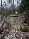
This is a trail of 1.2 miles in length and 350 feet of elevation gain. Though the trail is not very long or doesn't have much vertical elevation gain, it is the toughest and roughest trail in the park. Those famous boot eating rocks are found the entire length of this trail. On a clear day there are great views at many points along the trail. The trail also connects to the Overlook Trail to reach Hawk Point which affords the finest views.

 
Steepest Trail
 

Essential Gear

Comfortable hiking shoes and water.

Miscellaneous Info

If you have information about this route that doesn't pertain to any of the other sections, please add it here.

Images

Steepest TrailAt the top of the...Rhododendron Groves


"There have been joys too great to be described in words, and there have been griefs upon which I have dared not to dwell, and with these in mind I must say, climb if you will, but remember that courage and strength are naught without prudence, and that a momentary negligence may destroy the happiness of a lifetime. Do nothing in haste, look well to each step, and from the beginning think what may be the end.

© 2006-2012 SummitPost.org. All Rights Reserved.