
-
 3037 Hits
-
 72.08% Score
-
 2 Votes
|
|
Route |
|---|---|
|
|
42.88830°N / 1.9802°W |
|
|
Hiking, Mountaineering |
|
|
Spring, Summer, Fall |
|
|
A long day |
|
|
Overview
 Txurregui
This it's probably the longest route to reach Beriain but it's one of the most beautiful. The impressive fall of the ridge of Satrústegui to the North is marvelous, but it's dangerous in wet conditions or with snow. Great part of the route it's out of path and a good sense of orientation and map are very usefuls.
Slope: 993m
Time: 5h to summit (across the ridge) + 3h30min to descent.
It's possible to follow the route out of the ridge (using the route of descent) in 4h but the landscape it's better in the ridge (the most beautiful area of Sierra de Andia in my opinion).
Getting There
 Crossroad
 Txurregi
Some differents trailhead are possibles according with the route. Iltzarbe, Ollo or Senosian are the best villages of trailhead.
Getting there: from West (Basque Country) or North (France) or East (Aragón ) reach Pamplona. From Pamplona you go to Orcoyen (NW) following the road to Arazuri, Ororbia, Asiain until the crossroad of Anoz. The signal indicate Anoz and entry of valley of Ollo. In the first turn to left side we see the desviation to Ilzarbe (best place to the route of ridge).
If we want the easy route we follow the road to Ollo or Senosian.

If you has difficult to find this roads you can take the important N-240 in direction to Vitoria and in the village of Irurzun you must to take the road to Astrain and you reach the crossroad of Anoz from the north.
1)-Txurregi
 Txurregui
In the center of Ilzarbe (525m) we go in north direction across a track with the pyramid of Txurregi always present in front. After some huts we turn bordering the peak to reach an area in east side of Txurregi. We turn in a path to reach the Col of Ollariegi (835m, 45min) between Txurregi (left, 1125m) and Gaztelu (right, 1002m). It's possible the climb of Gaztelu from here and return (20min+10min) but if we want to climb the full ridge to Beriain it rest a lot of walk.
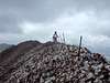
Searching a path near of the metallic fence we attack the hard slope of ramp north of Txurregi. In the ridge we turn to west to the mailbox of the summit of Txurregui (1125m). Great landscape.
 |
 |
 |
 |
 |
2)-Satrústegui
 Satrústegui
Leaving the summit of Txurregui in west direction we get the ridge. The terrain is easy initially in a plain but the boxwood appear to cover the path and the ridge. In some points we must to leave the edge to descent to evitate some falls and the vegetation. We reach a little summit less important called Aldemear (1136m) before to reach the vertex of the East summit of Satrústegui (1139m). It's not the highest point but the IGN and the maps called this summit as the main summit of the three of Satrústegui. After a little descent we try to follow the route near of the edge of the ridge but the path dissapear.
 Satrústegui
We reach the area of some little summits but the most important it's the last with a little cairn, it's the Satrústegui Central (1207m), really the summit of this part of the peak (it's called El Cascajo in some maps).
The path it's difficult to find and we cross a metallic fence in the upper side (near of the edge) to reach the rounded last summit of this part, the Satrústegui West or Idoitxiki (1271m) with a mailbox with the text "Satrústegui 1207m" (it's a mistake). Probably this central point of the route have some of the most spectacullar views.
3)-Idoitxiki-Amorro-Beriain
 Amorro
 Beriain
It rest still more boxwood but the terrain is easier and finally we reach easy hills without vegetation (at last!). After a little walk-up we cross the little summit of Idoitxiki West (1284m) to reach the important col of Portillo de Irañeta (1271m). We follow in west direction across the great hillside of Amorro (1345m) with a great cairn in the summit and we descent to a very wide plain. The main summit of Beriain it's visible to the west.
It's the easiest part of the route but the itinerary it's long. Little by little across some easy hills we reach the final ramp and the summit of Beriain (1493m).
4)-Descent
 Valley
 Track
TrackOf course the itinerary of full ridge it's not the best idea to the return. We leave the ridge in left side and search the path in the middle of the very wide plain. After a little col we reach a hut under the peak Leziza (1360m, in right side, south). In this point it's possible the descent direct in left side out of path or we must to take the little path of right side a few of meters more. We must to evitate the cairns and routes to south side (route of Goñi-Trekua).
A little forest it's visible in front of us and we evitate the trees turning to left side to reach a ruin of a hut and a small lake. After some meters we reach the forest track under the full ridge of Satrústegui-Txurregui. Following the track we reach the village of Ollo and following the road we arrive to Ilzarbe.