
-
 10420 Hits
-
 84.82% Score
-
 19 Votes
|
|
Mountain/Rock |
|---|---|
|
|
37.81507°N / 122.06141°W |
|
|
Contra Costa |
|
|
Hiking |
|
|
Spring, Summer, Fall, Winter |
|
|
2024 ft / 617 m |
|
|
Overview
 Mt. Diablo from Rocky Ridge north summit
The 4 summits at the northwest end command outstanding views of Mt. Diablo and most of the surrounding Eastbay hills. This section of Rocky Ridge requires a simple permit. The loop trail runs along the northeast slope to the top and back and requires no permit.
Getting There
 North from Rocky Ridge west summit
Loop Trail: Go through the Cattle gate at the north end of the parking lot and hike up .5 miles on a paved road. Take the Cuesta Trail on the left as it goes southeast approximately 1.4 miles along the northeast slope then curves right up to the 1,893' point on top of the ridge to the Upper Trail. The Upper Trail follows the top of the ridge northwest to the high point, Rock 2, at 2,024' then goes down to the right back to the Rocky Ridge Trail.
4 summits area: Same start as the Loop Trail but you continue on the Rocky Ridge Trail (road) to .8 miles to a gate where the Emud signs are posted. This is where further progress requires a permit. Continue another quarter mile up to a hanging valley with the main summit (fenced in area from the north) to the left, the west summit .2 miles across the valley over to the west and the north summit just up to the right. The west and north summits appear to be a few feet lower but are more interesting with trees and rocks and offer the best views to the west and north. The south summit is tree covered and a quarter mile south of Rock 2 and it's high point is a 15' class 5 rock pinnacle. See Klenkes' trip report.
Red Tape

Permit required for the 4 summits area info.
The Cuesta part of the loop trail could be quite muddy during the rainy season.
Camping
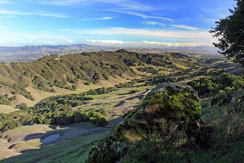 Bollinger Canyon from Rocky Ridge north summit
For current weather conditions
 Across the hanging valley to the north summit