
-
 8052 Hits
-
 0% Score
-
 0 Votes
|
|
Route |
|---|---|
|
|
37.11186°N / 118.53081°W |
|
|
Mountaineering, Trad Climbing |
|
|
Most of a day |
|
|
5.8 (YDS) |
|
|
III |
|
|
Overview
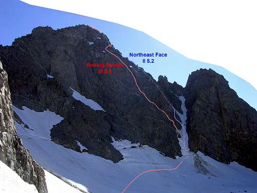
Rolling Stones, as far as I know, is a new route on the North East Face of Mt. Agassiz that I climbed with Vladimir Sofiyev in 2006. I suspect it's new because not only is there nothing in that area listed in Secor, but the rock was incredibly loose and there were no signs of anyone else having climbed the line. In fact, I don't really recommend this route, except perhaps in winter when much of the loose rock is covered in snow and frozen together.The route has two 5.8+ offwidth cruxes. The route may be harder now, as the second crux turned out to be a gap between a large detached block and the main face. The detached block peeled off as I finished the section.
So why did I put up this route? When the loose rock is covered in snow it might actually be nice. Also, it can serve as a warning of what line NOT to take if you're climbing the NE Face route!
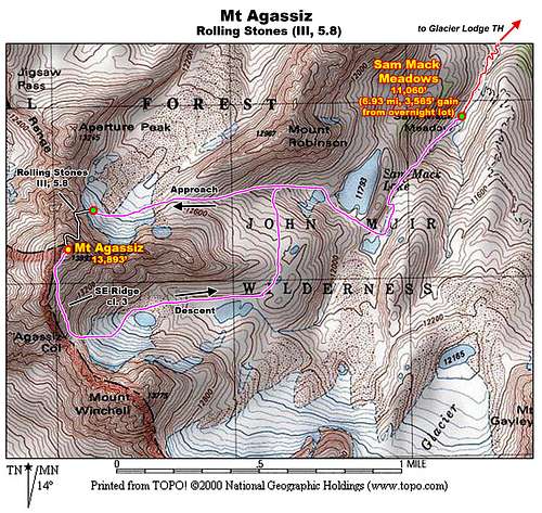 A topographic map showing the Rolling Stones route on Mt Agassiz from the common approach via Sam Mack Meadows.
| ||||||||||||||||||||||||||||||||||||||||||
Getting There
Approach via North Fork of Big Pine from the Glacier Lodge trailhead. Take the trail to Sam Mack Meadows and climb the right-hand chute (cl. 2-3), bypassing a large boulder on the right. This section can have a lot of water and some ice buildup in later season, and sometimes the easier variations involve climbing through spaces in the rocks. Next, follow the series of slabs in the drainage as you make your way to the Thunderbolt Glacier. When you reach the first lake at 11,790', ascend towards the right, passing another lake on your right as you aim for the saddle between the E Ridge of Mt. Agassiz and the W Ridge of Mt. Robinson. From there, head towards the prominent couloir that cuts up the right side of the NE Face of Mt. Agassiz.Another option could be to hike to 5th Lake and then head cross-country up the drainage that empties there. This may be a bit more distance, but not as steep. This might not be as good as it looks to require a lot more boulder-hopping, while the former approach has a lot of nice travel on slabs and meadow.
 Agassiz Col Agassiz Col |
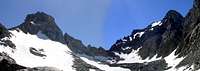
 SE Face & E Ridge of Mt. Agassiz. SE Face & E Ridge of Mt. Agassiz. |
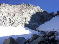 Rockfall on the north side of the E Ridge of Mt. Agassiz. Rockfall on the north side of the E Ridge of Mt. Agassiz. |
Route Description
Ascend the East Couloir that accesses the NE Face Route. After ascending about 100 ft, climb out of the couloir to the left, following a series of sloping ledges with lots of scree and sand. The ledges ascend at an angle in a series of 4th class steps as you angle up and left into the NE Face.The first third of the route (300 vertical feet) has a lot of loose rock but goes at 3rd to low 5th class. We simul-climbed it. One problem is that the follower cannot stay out of the fall line and the leader will probably knock down a lot of small rocks.
After the first third the terrain steepens for the next third (300 vertical feet) and the climbing becomes much cleaner. A thin ledge traverse leads over to a series of wide chimneys and left-facing corners, which go up to 5.8. The terrain here is still broken so we continued simul-climbing for most of it. The final "chimney", which transitioned to a mantle to a ledge on the left turned out to be a detached block that fell off as I finished it, so that section might be an easier or more difficult face climb.
For the last third of the route (300 vertical feet), you reach a broad ledge and the terrain above becomes vertical to overhanging. Here we traversed right through a notch and a short 4th-5th class downclimb to another ledge system. This ledge system wraps around and joins the upper section of the NE Face route, which is a nice 5.2 ridge. This ridge is clean and enjoyable to climb, leading all the way to the summit.
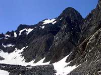
 Routes on the NE Side of Mt Agassiz.
Descent
From the summit the best descent is to downclimb the SE Ridge to Agassiz Col. This route is class 3, but snowfields linger late into the year, so bring crampons. If you descend this on a cold day or at night, the snow might be frozen and you will have to downclimb closer to the crest, which is broken cl. 5. The SE Ridge of Mt. Agassiz
Essential Gear
Helmet!A backpack is good for protecting the rest of your body from bouncing rocks.
For pro, bring a standard alpine rack ranging from nuts to 2.5" cams.