
-
 27040 Hits
-
 72.08% Score
-
 2 Votes
|
|
Route |
|---|---|
|
|
31.86455°N / 106.49082°W |
|
|
Hiking, Scrambling |
|
|
Spring, Summer, Fall, Winter |
|
|
Half a day |
|
|
Strenuous |
|
|
Overview
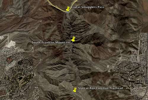
The Ron Coleman Trail goes from McKelligon Canyon to Smugglers Pass on Trans-Mountain Rd by way of South Franklin Mountain. The trail is named after Ron Coleman, an El Paso Congressman who worked to protect the Franklin Mountains.
Getting There
From I-10: Head North on US-54 Patriot Freeway to the Fred Wilson Rd. Exit. Turn left (west) on Fred Wilson Rd. Follow it to the left as it turns into Alabama Street. Continue to McKelligon Canyon Rd and turn right to enter the Park.
From the far west or east sides of town take Loop 375 (Also called Trans-Mountain if traveling from the west side and Joe Battle if you are coming from the east side.) and exit onto US-54 South. Exit onto Fred Wilson and turn right (west). Follow it to the left as it turns into Alabama Street. Continue to McKelligon Canyon Rd and turn right to enter the Park.
Once at McKelligon Canyon continue to the far end of the park, the trailhead is in the very back parking lot. It is recommended that you leave one vehicle at Smugglers Pass on Transmountain and then drive another to the trailhead at McKelligon Canyon.
Route Description

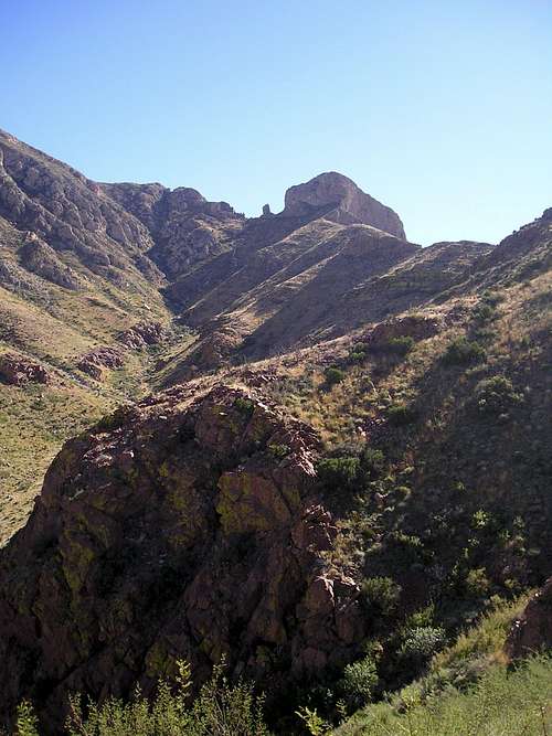
The Window
From the trailhead at McKelligon Canyon follow the blue trail markers. Continue up and to the right past the first cave, then to the left past the second cave.
At 0.58 miles as you reach the ridgeline, turn right and follow the trail north.
At about 1.45 miles, there is a split in the trail. Follow the slightly lower trail to the left. The trail is hard to find over a few rocky areas that you will have to scramble over.
At 1.75 miles, you will climb a wall to The Window, climb the left wall up to find the trail on the top. Continue along the trail and you will see the FAA towers to your right, which are located on the peak of South Franklin Mountain.
To reach the peak you have to detour from the trail and travel up to the towers. Use caution as it is steep, loose, and covered with desert fauna like Prickly Pear Cactus and Yucca Plants.
Once back on the trail, stay to the left and follow the ridgeline down to the parking area at Smuggler's Pass on Trans-Mountain Rd.
The trail is strenuous in places and requires scrambling over rocks and steep inclines. Be sure to take plenty of water, especially during the hot summer months, and give yourself 3-4 hours to complete the hike. The trail is 3.8 miles one way, add a little more for the detour to the summit.
Essential Gear
Please remember that this is the desert and it gets very hot during the summer months, therefore It is very important to take plenty of water. Sunscreen is also a good idea as the Franklin Mountains offer little or no shade. Good hiking boots or shoes will make your hike much more enjoyable. Please be safe and enjoy your hike!
External Links
A great write up of the trail complete with many pictures can be found at the Sierra Club of El Paso's website.
A bunch of pictures can be seen at this Gallery from the El Paso Ridgewalkers
Another great write up with pictures can be found at nm climber.com