
-
 38135 Hits
-
 81.68% Score
-
 15 Votes
|
|
Route |
|---|---|
|
|
41.40940°N / 122.1939°W |
|
|
Mountaineering, Scrambling, Skiing |
|
|
Spring, Winter |
|
|
One to two days |
|
|
Grade II - Class 3/35-55 degree slopes |
|
|
Approach
Approach to this route begins from Bunny Flat trail-head. Start up the trail towards Avalanche Gulch but instead of following the trail left towards Horse Camp, ascent a ridge (Broadway) which will lead the climber right towards Green Butte. Green Butte Ridge is the ridge East (Right) of Avalanche Gulch, and offers a more direct line to the summit than Casaval Ridge (on the West side of Avalanche Gulch). One may join the ridge at any point before about 10,200ft.
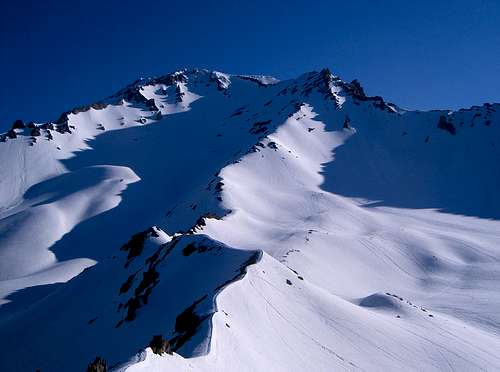
Route Description
The Green Butte Ridge proper begins at about 9200', just above Green Butte (El. 9193'). Ascend this sometimes narrow ridge approximately 3000' to a rock outcropping known as "The Thumb" (El.12,923'). During Winter months this ridge can be knife-edge in certain areas with exposed class 3 rock encountered. After winter storms the slopes are more gradual and rock is mostly covered. There are several great opportunities to camp directly on the ridge, especially at about 10,200ft. Above 10,200ft camp site the ridge begins to steepen and move towards the junction of Green Butte and Sargent's ridge. Steepest traverses towards the junction are mabe 40 degrees at most. Before the junction one may encounter some class 3 rock during dry years. Stay on the crest of the ridge and move to the snow slopes on the East (right) side to continue towards scree and the junction with Sargent's ridge. From there one may choose to climb over the crest of the ridge all the way to the Thumb, but it will involve a few class 5 moves on unstable volcanic rock. Ridges merge between Shastarama point and the Thumb at about 12,200 ft. While on the East side of the ridge continue traversing up on the snow slopes above Mud Creek Glacier. Climber may choose to cross to the other side of the ridge or continue traversing all the way till moderate to steep slopes allow an exit towards the Thumb.
Past The Thumb climb up and left toward Misery Hill, following the path of least resistance. Ascent Misery Hill and continue across the football field sized plateau towards the summit rocks.
Descend the route or Avalanche Gulch if desired.
 |
 |
 |
 |
 |
Essential Gear
Crampons and ice axe are required to climb this route. One may want to bring snow shoes and trekking poles for approach. If group does not feel comfortable traversing up to 55 degree snow/hard icy slopes pickets may be useful to protect steep and exposed sections. Bringing pickets or ice screws will require roping up. I have never done that, but seen people with ropes with harnesses on. Contact Ranger station for current information on the route.
Mt. Shasta Ranger Station (530) 926-4511
Miscellaneous Info
Contact me to add any information on the route.
For current updates contact climbing rangers at Mt. Shasta Ranger Station (530) 926-4511. They are very helpful and will help with latest weather trends, avalanche condition, load of snow on slopes, predicted wind etc.