
-
 94772 Hits
-
 90.81% Score
-
 33 Votes
|
|
Route |
|---|---|
|
|
45.16318°N / 109.80823°W |
|
|
Mountaineering, Scrambling, Skiing |
|
|
Spring, Summer, Fall |
|
|
A few days |
|
|
Class 3 |
|
|
Overview
Round trip distance: approx 28 miles
Elevation gain: approx 4500'
Difficulty: Class 3
The south face of Granite Peak has confused and mystified many people in the past and rightly so. It is a complex face with many ridges, gullies and slabs of varying sizes. Depending on your ability level, there are probably dozens of ways one could reach the summit via this face, however the easiest route will be described here, known as the SW Couloir (or SW Ramp...see below). This route is even quickly becoming the standard route for Granite Peak due to the easier terrain encountered higher on the mountain and the more enjoyable approach. Unfortunately this route also has a decent amount of loose rock and could be considered more dangerous than the "standard" Froze to Death Plateau/East Ridge Route, which is a very enjoyable scramble on excellent rock. Although it is still currently less popular than the standard route, it won't be long before this becomes the most popular route on the mountain. The approach for this route is by far the most beautiful way to reach the mountain. Although the Huckleberry Creek Approach is also fantastic, and both are better than the Froze to Death Plateau approach, the hike past Aero Lakes or Rough Lake into the Sky Top Lakes basin is unsurpassed. If you like fishing bring your rod too!
Allow two days for the trip, plus a day to sit out bad weather if necessary. One way distance from trailhead to summit, depending on your exact route (much of this route is off-trail) is about 13-14 miles. The entire approach is scenic and wild. It features alpine meadows bursting with flowers in the summer, extensive boulder hopping, a couple long hills, and more than one significant stream crossing. Come prepared as it will excite you, but also wear you out! Also be aware that although this route is easier than the east ridge, it is no walk in the park. People attempting this route should be proficient, and prepared for steep loose rock, and steep snow.
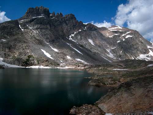
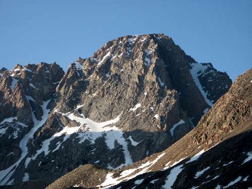
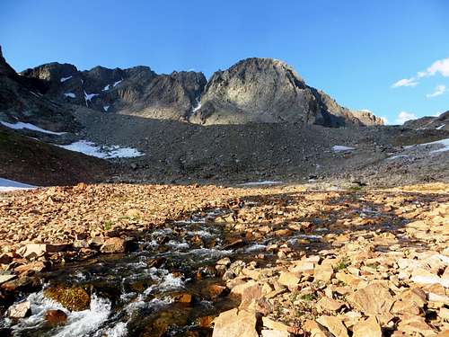 Granite Peak from the Sky Top Lakes basin
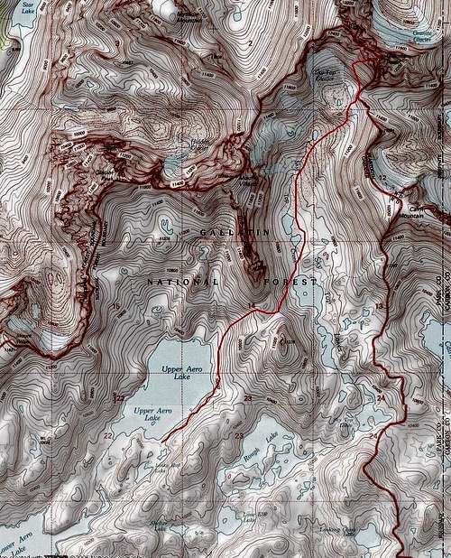
Getting There - Lady of the Lake (Aero Lakes) Trailhead
Getting to this trailhead seems to be the most difficult piece of route finding but it is actually quite simple. On my main Granite Peak page I named this the Aero Lakes Trailhead but many people call it the Lady of the Lake Trailhead. You start the approach here, which is just a few minutes away from the tiny town of Cooke City between Gardner and Cody. See the map below for the route to the trailhead.
From Cooke City, drive east on US Highway 212 (Beartooth Highway) a little less than 2 miles to the Lulu Pass Road and turn left (north). After two miles, there is a new large gravel parking area on the right that's impossible to miss. This is the new standard trailhead, where a 10 minute walk on the trail takes you to the old trailhead described just below.
To get to the old trailhead and shave off 10 minutes of walking, continue another third of a mile or so past the new large parking area to a large, signed junction (Goose Lake junction), and turn sharply right onto a short dirt road. Continue on this rough, rutted road (but still passable for most cars) for a quarter mile to its end at the small mining cabin with mining relics scattered around. There is room for about 6-8 cars here to park next to the old mining cabin (this is probably why the new parking area was built). To get to the actual start of the trail, walk around the cabin on the left side (passing an old hot water heater) and cross a small stream on some boards or rocks. Emerge from the bushes and onto the trail after a few feet of bushwhacking and walk northeast on the trail passing a large sign for Lady of the Lake. The trail from the new parking lot also intersects at this sign.
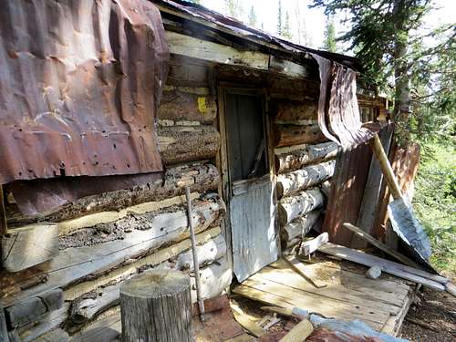 Old mining cabin at the TH Old mining cabin at the TH |
 Sheep Mountain from the Lulu Pass Road Sheep Mountain from the Lulu Pass Road |
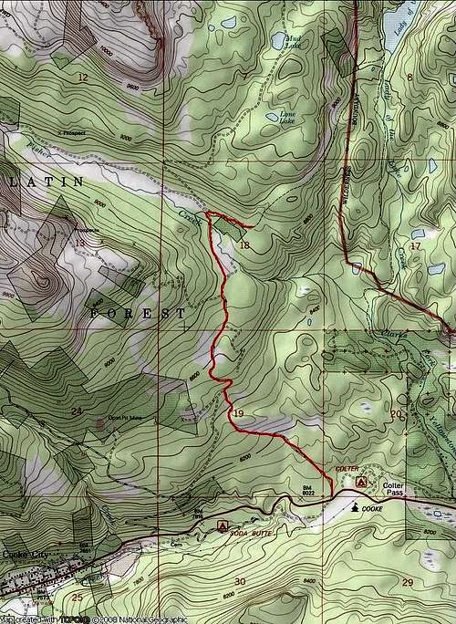 Aero Lakes Trailhead Access Map Aero Lakes Trailhead Access Map |
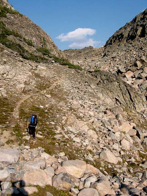
The Long Approach
AERO LAKES APPROACH
From the lower trailhead, there is a large cabin nearby just to the east. Walk around it on the left side (passing an old hot water heater) and cross a small stream on some boards or rocks. Emerge on the trail after a few feet of bushwhacking and walk northeast on the trail passing a large sign for Lady of the Lake. The first part of the trail heads up a short steep section and mellows to a nice undulating hike through sparse forests reaching the south end of Lady of the Lake at 8,750 feet after 1.5 miles. Follow the trail around the west side of this large lake (with great fishing and camping) and reach the junction with the trail coming down from the upper trailhead after another mile. A large cairn marks this junction. Continue straight and pass around a large meadow and cross a small creek which flows back down to Lady of the Lake. Don't follow this creek as it curves back to the south. Utilize rocks and logs to get across, then stay on the trail heading up through some trees and reach an obvious (but unsigned) trail junction 0.5 mile from the creek crossing. A few logs block a trail heading straight, however this trail is the route for the Sky Top Creek Approach described below. I will call this trail junction the Tri-Creek junction since it's where Zimmer Creek, Star Creek, and Sky Top Creek converge to form the Broadwater River. For the Aero Lakes route, you want to take the left trail. Your first views of Mount Zimmer and Iceberg Peak are found here to the north. A few minutes beyond the Tri-Creek junction, cross Star Creek a few feet before it dumps into Zimmer Creek and continue up the trail which follows the west side of Zimmer Creek for another mile. When the trail once again reaches the creek side, cross it on a couple large logs at 9,150 feet and locate the trail heading northeast towards Aero Lakes. This junction is unsigned so don't miss it and continue up Zimmer Creek. The trail quickly begins to climb steeply for 900 feet up what is known as heartbreak hill, reaching Lower Aero Lake after another 1.1 miles at 10,000 feet. The final quarter mile to the lower lake is hard to follow, just follow large talus through an obvious gap and descend 50 feet to the lake shore.
Here at the lower lake, the official trail ends (5.4 miles from the TH) but a boot path heads west around the lake, reaching its southwest corner after 0.3 miles which has a nice calm area making for great fishing. Continue along the northwest shore for another 0.9 miles and reach a small stream coming down from the northwest which drains a small lake above and to the north. Descend 50 feet to the creek, cross to its east side, and follow this drainage up to a very broad 10,160 foot saddle. Descend a short ways to the upper lake outlet stream and find a place to cross it. Wading may be required in early season. Reach the Upper lake at 10,170 feet and hike east around its south shore, then north around the east shore for 1.3 miles from the outlet. Stay close to the shore on the east side to avoid annoying talus traversing. Begin an ascending traverse and cross a small stream reaching a small tarn at 10,330 feet (200 feet above Upper Aero Lake). The camping at this tarn is fantastic and out of the bugs that flock the lake shore below. Views of Glacier, Villard, the Spires and the upper lake below are out of this world! This beautiful spot is 3.3 miles from where the official trail ends making the total distance 8.7 miles from the trailhead with only a 1,500 foot net elevation gain.
 Hiking up heartbreak hill to Aero Lakes Hiking up heartbreak hill to Aero Lakes |
 Villard Spires from the Upper Aero Lake Camp Villard Spires from the Upper Aero Lake Camp |
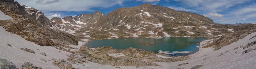
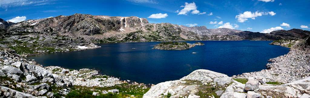 Lower Aero Lake Panorama
SKY TOP CREEK APPROACH
From the Tri-Creek junction (see above), instead of taking the left trail for the Aero Lakes approach, continue straight and follow the trail as it heads along the right (south) side of Star Creek for a few minutes. Locate a place to cross Star Creek on logs or rocks and pick up the trail on the north side. Continue to follow the north side of Star Creek downstream in an eastward direction and descend on the trail about 100 feet to Sky Top Creek. This entire Tri-Creek Junction is confusing since many social trails criss-cross the large meadow where these three creeks converge. Best to avoid trying to find the correct route through here at night. Parties have gone in circles here for hours in the past.
The trail reaches the north/west side of Sky Top Creek and continues near its shore for 0.75 mile to the stream draining Aero Lakes. Cross this barrage of streams and marshland on mainly well placed logs (or wade in early season) and locate the trail on the other side. Continue another 0.75 mile to a large flat meadow at 9,400 feet. The trail follows the left side of this half-mile long meadow. Just before the large cascade at the head of the meadow, the trail heads up to the left, over a small ridge and begins climbing steeply for another mile to Lone Elk Lake at 10,065 feet. Shortly before reaching the lake, the trail crosses a small stream draining Shelter Lake off to the north and passes over a small saddle to bypass the waterfall a few feet below the lake. The first real good views of the Villard Spires can fe found at Lone Elk Lake.
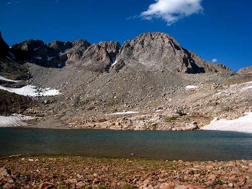
Hike around the left (west) side of the lake and cross the inlet stream above the small cascade. Continue around the right (east) side of Rough Lake which sits at 10,140 feet and hike up the right side of its inlet stream through a narrow gorge. Cross to the north side of this stream when possible (jump across a narrow section) and hike up the hill and reach the top of a broad ridge at 10,450 feet to the left (west) and roughly 100 feet above Lower Sky Top Lakes. Hike around the left side of the Lower Lakes and descend to the west shore of the two-part upper lake. Continue along the west shore of the upper lake (which is divided into two sections by a short stream) and set camp on a small flat patch of grass at the north end of Upper Sky Top Lake just below the 10,840 foot saddle between Point 11,379 and the Villard Spires. Camp is at an elevation of 10,480 feet. This approach is 9 miles each way from the trailhead with a net elevation gain of just over 1,600 feet.
 Rough Lake Rough Lake |
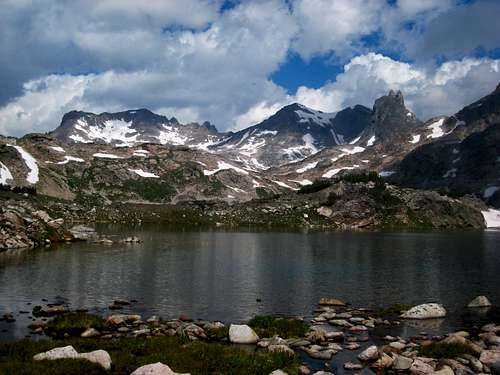
 Villard Spires from Sky Top Lakes Villard Spires from Sky Top Lakes |
Route Description
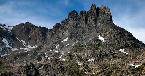
Starting From the Sky Top Lakes valley southwest of Granite Peak, aim for the lower right corner of a massive slab on the southwest face. Scramble up the talus in a northward direction, passing by a beautiful green tarn and continue off to the right to the base of the slab. Make sure you stay right, close to the low saddle between Cairn Mountain and Granite Peak, as the cliffs further left can be 4th class to ascend. There is typically a snowfield you have to ascend or cross as you cut back left to the base of the slab. Unless it's a very dry year expect snow here where crampons and an ice axe are required. Traverse to the left along the base of the slab until you reach to left edge. Here you have two options for the route, Couloir 1 or 2, and they have been confused in the past. Note that some people call the shorter Couloir 1 route I describe below as the SW Ramp, such as Steve's route description linked at the bottom of this page. Most people probably don't even know there is a second couloir and do couloir 1. Don't fret over the fact there are two options though, as I am going to recommend you do Couloir 1 described first below. It's just simpler overall, shorter, and much safer. The photo below is taken from Steve's description and shows the two options. He labels what I have dubbed Couloir 1 as the SW Ramp route. When I descended the mountain after doing the Granite Peaks Traverse, I went down this route, and from my studies, most people do this route anyway.
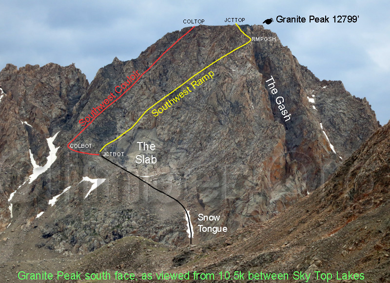 South Face of Granite Peak with the two routes labeled
SW Couloir 1 (SW Ramp in the photo above; Most people call this the SW Couloir) - Do this route it is much better!!
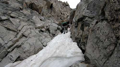
From the left edge of the large slab, immediately turn right and enter the small gully (which is known as the ramp) and ascend up the top of the large slab initially, then continue up the gully. This small gully has a bunch of steep rock, so be ultra careful not to rain boulders down on your fellow climbers below, and watch for people above you. Most of the gully is straight-forward, but the crux is a small steeper step which typically holds snow. People have been able to scramble around this snow step or if you have crampons you can put them on. Hand lines have been placed here as well. Past this crux, the gully will end with large blocks above you to the left, and you will reach the small ridge overlooking the gash. Scramble up to this ridge where the terrain abruptly ends and the gash becomes visible as a huge drop below! When you gain the ridge, follow it up and left on now fairly solid rock. This ridge takes you directly to the summit ridge where you can then walk a few yards to the right to the highest point. Cairns mark the route from the point where the gully (ramp) meets the gash to the summit.
 Passing the small tarn Passing the small tarn |
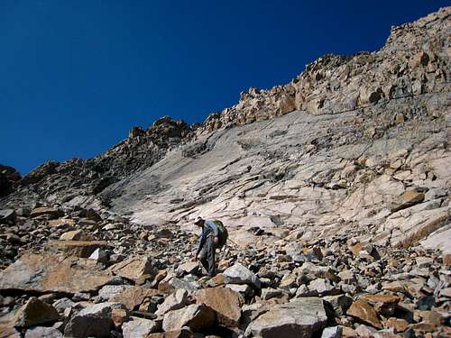 Looking up at the slab marking the start of the SW couloir Looking up at the slab marking the start of the SW couloir |
 Typical snow coverage in late June Typical snow coverage in late June |
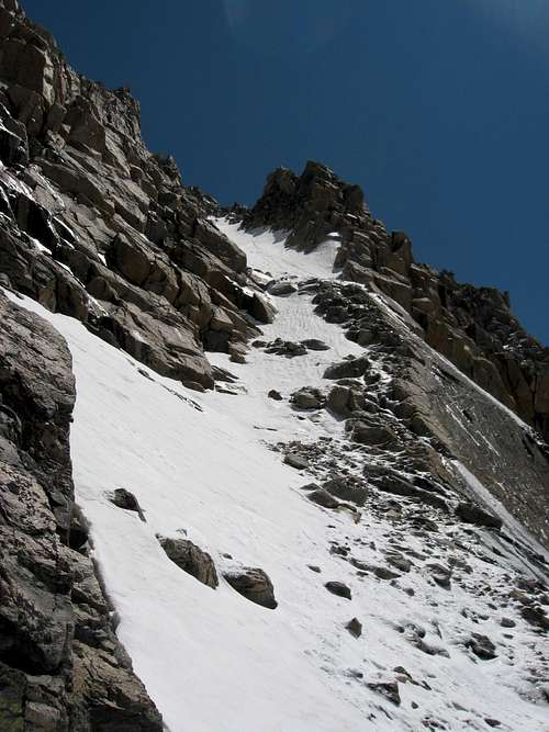 At the base of the couloir with more snow At the base of the couloir with more snow |
 Going up the little snow patch at the crux step Going up the little snow patch at the crux step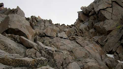 Near the top of the couloir, stay right here to reach the ridge above the gash. Near the top of the couloir, stay right here to reach the ridge above the gash. |
SW Couloir 2
I have not done this route but people do not recommend it. It apparently has even more loose rock and typically holds ice longer than option 1 above. From the left corner of the slab, instead of heading up the obvious gully, if you traverse right a few minutes and cross onto the darker colored rock, you will come across another, steeper gully that cannot be seen from anywhere really. Climbing this route may involve ice climbing...the end. If you do this route, it will dump you out on the summit ridge further west than the other route and you'll have to walk east on the summit ridge a little longer to reach the summit.
Other Links
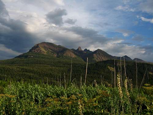
Panorama of Granite Peak and Cairn Mountain
jimboa - Aug 29, 2008 12:42 pm - Hasn't voted
SW Couloir TrailheadThe actual distance up Lulu Pass Rd. to the turn off/parking is only about 2.3 miles. A good landmark for parking is where the Goose Creek Jeep Trail branches off to the right. Park here (unless driving a 4X4) and take the hard right there to continue to the trailhead 1/2 mile further down a rough road and back across Fisher Creek. There is a well marked trailhead there for Lady of the Lake trail as well as a parking area for 4X4 vehicles.
Larry V - Sep 6, 2008 5:46 pm - Hasn't voted
Thanks ...for the updated information on getting to the trailhead! I have incorporated your comments on the route page. It is confusing, and seems to have changed since I was there 10 years ago.
phatty - Jul 3, 2013 12:46 pm - Hasn't voted
Round Lake cuttofffor those with 4x4 vehicle, you can continue north to round lake. about .3 miles past round lake there is a spur trail from the main road that cuts down (north easth) to the lady of the lake trail (1.3 miles i think). This would shave a few miles off the approach.
ClimbingRandy - Nov 30, 2013 9:02 pm - Hasn't voted
Re: Round Lake cuttoffPhatty - Have you done this approach before? Or just spyed the topo? Anyone else? Randall
admiralbrown - Apr 3, 2014 1:37 pm - Hasn't voted
Re: Round Lake cuttoffI did Granite in August 2013 starting from the parking off Lulu Pass Road. Three day solo. Much easier than going over Froze to Death Plateau. This will become the official route for the High Pointers Club. When Don Holmes wrote his book, he got mired in snow trying this route and never mentioned this route again. Avoid the cutoff past the Aero Lakes and instead stay to the east to Rough Lake. Keep Rough Lake on your right and take the lowest saddle to the Sky Top Lakes. Very rocky trying to hike past the the Aero Lakes. Easy trail to follow to the Sky Top Lakes, lots of people camping and fishing. I took the Ramp up and not the Couloir, the Ramp is just to the right of the Couloir at the base of the Slab. Key note is three quarters of the way up the Ramp, you exit to the right over a saddle and follow between the Ramp and the Gash to the Summit. Day one hike to Sky Top Lakes, day two summit, day three hike out.
BurnsAJ - Nov 8, 2018 8:31 am - Hasn't voted
Re: Round Lake cuttoffClimbingRandy; I know this is a really old question - however I did this route this summer with my son, and thought it was worth posting some information. Yes, taking the Goose Lake 4 wheel trail is a major mile saver IF your vehicle can handle it. To others' points, Lady of the Lake is only 1.5 miles or so from the upper trailhead, but if you do the Goose Lake Trail right you park your vehicle by Companion Lake or Southern Long Lake (not Round Lake) and are about 3/4 mile of easy bushwhacking from the broadwater river junction... this is a savings of around 4 miles one way and starts at a significantly higher elevation. With an 8 year old along, cutting off that many miles was definitely worth it. Now about your vehicle capability, make sure you have offroad rock tires and if you have a longer wheel base vehicle (think suburban or Expedition) you are really pushing it even with decent lift. I did it in an expedition but was scraping badly. Right before the goose lake trail doubles back on itself near the beginning there are a couple points which most long wheel base vehicles will not make it over. If you get past those you should be good to Round Lake at least (unless water is high). To that point, if you do this during high water you have a completely different set of problems to deal with around Mud Lake and Round Lake. Make sure you have a winch or come along with strong chain. Andy
jdarr67 - Jul 16, 2014 10:11 pm - Hasn't voted
TrailheadThe Lady of the Lake TH is just past the cutoff road that goes left to the southeast foot of Henderson Mountain. There have been many changes to this area since 2011. The Sawmill Road TH way is shut with private property/no trespassing signs. A Forest Service employee told me the Lulu Pass TH cuts 3 miles off the hike to Lady of the Lake. The new TH is a larger parking area with a well marked TH sign and new gravel surface. Too bad so much confusion is associated with this trail head. Just spotting from the Henderson foothills shows that there is still a lot of snow up there. Villard looks like it might be doable right now. Admiralbrown, have you climbed over the cutoff past Upper Aero? Anyone been up this year?
Bobber - Aug 9, 2014 4:44 pm - Hasn't voted
It's the Forest Service employee that is confusedThe standard way in to the start of the Granite Peak trail is still there and open. There are no "No trespassing" signs. Park right there by the old cabin as usual. The Lady of the Lake is only about a mile and a half from the Lady of the Lake trail head which is about 1/2 mile below the cabin. I don't see how you can save 3 miles on a mile and a half hike. Perhaps the FS person is confusing Lulu Pass Rd which the Lady of the Lake trailhead is on with Lulu Pass. Don't start at Lulu Pass!!!! We topped out on August 7, 2014. There were 2 of us and a dog and the dog made it to the summit. My friend did help the pup up a through the big rocks in the couloir and lowered it by rope connected to the handle on the dog pack here and there on the way down. There was the typical 2 snow/ice sections in the couloir. The lower small one was really easy and someone had left a sling to help you over the big rock at the top of that one. They cut in some real nice steps in the larger upper one and we felt pretty safe through these with no gear at all. At first we didn't see them and almost turned back because it was really difficult avoiding this one. There IS loose rock almost everywhere in the couloir so we went one at a time in those tricky places. Knocked a few loose too! Also...When you are walking along the use trail at the bottom of the big granite slab there are 2 small gullies just past the black stain both of which lead to the main couloir. The 2nd one is easier and someone had left a rope there to help get you over the rocks. Also the couloir splits into 2 narrow gullies separated by a good rock band near the top so stay on the right side like others posted. At the top of the couloir where others said to turn right aim for that notch on the right. It looks like a crazy knife edge from below but there is a pretty good goat trail just on the other side. It's actually the easiest part of the couloir and it will start heading left like they said. I went under the giant rock to connect with this on the way down from the summit. The entire summit day was a wonderful, intense and very strenuous one. Ain't nuttin easy about it. The goats walking around and pawing at our tent at Rough Lake all that night were a PIA!!!!! And your dog better be really trail hardened to make this trip. It was my friends dog and he was adamant about taking him but I wouldn't do it. That dang dog was also on top of Gannett Peak in Wyoming about 2 weeks before so he is quite the mountaineermutt. My friend said Gannett was easier. You will need a good dog pack so you can help the pup out and you will help him out a fair bit and that will slow you down.
Gaddillac - Sep 10, 2014 5:51 pm - Hasn't voted
NOT RECOMMENDED ROUTEI work for Beartooth Mountain Guides in Red Lodge, and Ive noticed a lot of questions about this route recently. THIS ROUTE HAS SIGNIFICANT ROCKFALL HAZARD!!! While it may be considered "less technical" than the East Ridge standard route, in the couloir you are exposed to rockfall potential from humans, goats, etc. I would consider it rolling the dice, some people (and their pet) may be fine-others may not. Weigh that risk seriously when attempting this route. It has been intentionally left out of many Granite Peak publications because author's did not feel that it was safe to recommend. The Beartooth Ranger District is on the same page. If you still feel compelled to attempt this route, please take extreme caution with loose rock, as everyone below you-even those unseen-could be harmed if you are not. AND PLEASE WEAR A UIAA APPROVED HELMET!
musicman82 - Sep 13, 2014 1:35 am - Voted 10/10
Re: NOT RECOMMENDED ROUTEI'm with Bobber here and strongly disagree with this post; yes, there is rockfall hazard, but I will take that any day compared to a technical route. Any serious peakbagger with scrambling skills on loose rock will be fine on this route - just take the obvious precautions (like a helmet - duh) and enjoy this great way up an amazing mountain! Maybe the guide services don't recommend it because they'll lose business as more and more people use the easiest route on the mountain...
Matt Lemke - May 12, 2015 8:44 pm - Voted 10/10
Re: NOT RECOMMENDED ROUTE"Maybe the guide services don't recommend it because they'll lose business as more and more people use the easiest route on the mountain" Bingo. Although the guides typically don't enjoy bringing newbies up Granite all summer, they do need their paychecks. This route does have more rockfall danger than the east ridge but nothing out of the ordinary.
Gaddillac - Aug 28, 2019 10:03 am - Hasn't voted
Re: NOT RECOMMENDED ROUTEAs of this week, TWO CLIMBERS HAVE DIED in the Southwest couloir since i posted my comment. That's two more fatalities than any other route on the mountain. There was also a short haul rescue last week for a climbed who broke their leg in the couloir. So please, keep debating my motives. https://billingsgazette.com/news/state-and-regional/minnesota-climber-falls-dies-on-montana-s-highest-peak/article_ea94605b-aea9-5a47-9d1d-c020a78fdf4d.html#tracking-source=home-trending
Bobber - Sep 12, 2014 11:27 am - Hasn't voted
It's not that dangerousI have to disagree with Gaddilacs post. I know of several people who have climbed the standard route without any gear and that is far more dangerous because of the extreme exposure. I haven't done it that way but I've seen all the pics here and elsewhere and it's much harder and scarier for those without a rock climbing background. This way is far easier (but still a bitch) and really not technical at all except for those snow patches and in late season with an average snow year they would be melted away. We were never in fear of falling to our deaths. And with so many easier summits that still have a rockfall hazard this is just part of the risk we take. Just go one at a time through those questionable sections and you will be OK. I really believe it is a disservice to the climbing community not to include this easier route in your guide. My 2 cents.
musicman82 - Sep 13, 2014 1:35 am - Voted 10/10
Re: It's not that dangerousWell said!
Bobber - May 9, 2015 2:22 pm - Hasn't voted
The start of BroadwaterNice page redo Reboyles, there is one correction that i think should be made.You state "I will call this trail junction the Tri-Creek junction since it's where Zimmer Creek, Star Creek, and Sky Top Creek converge to form the Broadwater River". According to my topo Broadwater starts at the intersection of Star and Zimmer. The name Broadwater River is right there. Skytop flows into Broadwater about a half a mile down to where your route is. People might get confused with the topo and the route description. I didn't go this way and went straight ahead and crossed Broadwater right at the start of it and took the decent trail to the right. I wonder if this is the easier way? I posted a pic of the cairn with the stick in it which shows the way to the Skytop Trail after crossing Aero Creek. You might want to put that in your page. Nice work. 2 thumbs up!!!! PS After Chilidog summited Gannett and Granite he has now also bagged the highpoint in Mississippi. That dog gets around. LOL
Matt Lemke - May 12, 2015 8:33 pm - Voted 10/10
Re: The start of BroadwaterI actually just finished re-doing the page. I will incorporate what you said into the page though. Thanks for clarifying!
reboyles - Jun 7, 2015 10:26 am - Voted 10/10
Re: The start of BroadwaterMatt, Nice job on the rework. It's much better than anything I could have done. Man, it makes me want to go back again. Bob
Bobber - Jun 12, 2015 9:51 pm - Hasn't voted
One more timeI'm thinkin about another climb just for fun this August. Maybe reboyles will want to go with me?
reboyles - Oct 11, 2015 2:37 pm - Voted 10/10
Re: One more timeOh man, I missed your reply. A group that I was going to join went in September and here is their report. I could not get away this summer. http://fadgenfamily.blogspot.com/2015/09/granite-peak-12799-feet.html Bob
Ocotillo - Aug 6, 2016 7:33 pm - Hasn't voted
July Conditions & Helpful HintsMy husband and I summited Granite Peak via Sky Top Lakes and the SW Ramp on 21 July 2016. The ramp above the "crux" was filled with snow, probably for 400-500 feet. (We had a 100 ft rope with us that we used to belay each other). I wish we'd brought a 60 meter rope so we could have rappelled through here on the way down. It would have been so much faster. Could have used it in the snow finger at the start of the climb, too. Helpful Hints: From the north end of Sky Top lakes, stay along the creek and tarns for an easier, faster approach to the snow finger (aka snow tongue). It's fairly level and smooth - mostly on snow. We however took a straight line and it took us over rough boulder fields where we were gaining and losing elevation - NOT efficient. Also, we're not young whipper-snappers anymore. We decided to hire outfitters to take us to Lone Elk Lake and drop us there. It was worth every penny. Only one outfitter in town that'll take their animals on that trail: Skyline Guest Ranch and Guide Service. The other outfitters that we talked with did not feel their horses were appropriate for this trail. Skyline steeds and guides were awesome. It's an option definitely worth considering.