
-
 34598 Hits
-
 81.84% Score
-
 14 Votes
|
|
Route |
|---|---|
|
|
45.16330°N / 109.8072°W |
|
|
Hiking, Mountaineering |
|
|
Spring, Summer, Fall |
|
|
A few days |
|
|
Class 2+ |
|
|
Overview
The approach to Granite Peak via Huckleberry Creek seems to be a lesser traveled approach route than the FTD Plateau. Regardless of its lack of use, this is an incredibly beautiful, off-trail hike to Avalanche Lake. The hike begins at the West Rosebud Trailhead. I actually prefer this approach however many others will disagree. Below is a list of pros and cons for each approach. Note that the directions for the FTD approach is on the main Granite Peak page.
| Pros | Cons |
| Safe from thunderstorms since you are in valleys | More bushwhacking |
| Unlimited supply of water along Huckleberry Creek, Princess Lake and Avalanche Lake | Very rough boulder hopping around and above Avalanche Lake |
| This approach is much more scenic and has much better camping opportunities | Moderately steep snow climbing on the final 500 feet to the saddle |
| Princess Lake offers fantastic fishing | |
| Less elevation gain |
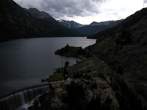 Mystic Lake dam Mystic Lake dam |
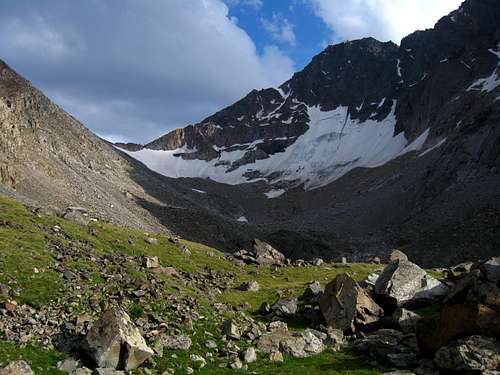 View to the saddle from Avalanche Lake View to the saddle from Avalanche Lake |
Route Description
On this route, you cannot even see Granite Peak until you are nearly under its daunting north face. You will hike, bushwhack, boulder hop, ascend alpine meadows, then finally after reaching a messy ridge of house-sized boulders, there before you is the north face of Granite Peak. It is impressive to see the mountain from Avalanche Lake and worth every boulder you will hop-over to get there. This route description for the Huckleberry Creek approach begins at the West Rosebud Trailhead and ends at the Bivouac Saddle, between Granite Peak and Tempest Mountain. At Bivouac Saddle the route then continues on the "South Face via East Ridge/Standard Route". Refer to Alan Ellis' detailed route description of the "South Face via East Ridge/Standard Route" for the remainder of the climb.
Leaving the West Rosebud Trailhead, continue up the maintained trail until you reach Mystic Lake (3 miles). Once you are at Mystic Lake you will then intersect with the Phantom Creek trail. Do not take this trail, it heads up and out of the valley and it will bring you to the Froze-to-Death Plateau. Instead, continue along the trail (1.5 miles), following the south shore of Mystic Lake. The trail then intersects with Huckleberry Creek where it empties into the southwest end of Mystic Lake. Huckleberry is the last creek crossing along Mystic Lake, before the trail turns slightly north and goes between Mystic and Island Lakes. This area would make a great campsite if getting a late start. From this point forward, you will be route-finding, bushwhacking and picking your way through boulder fields. Even though this is an unmaintained trail, it seems the trail is becoming more established and the route is a bit easier to find than a few years ago. It isn't too terribly bad, but not all that easy either.
After crossing Huckleberry Creek on the footbridge, follow a faint climbers trail up and along Huckleberry Creek, leading you in a southerly direction, up and out of the Mystic Lake basin. This section to Huckleberry Lake is fairly steep, but easy to follow. The climbers trail is fairly well established and keeps you to the right (west) side of Huckleberry Creek. You will not see the creek again until almost reaching Huckleberry Lake. At Huckleberry Lake, you reach the first boulder field. There are a few cairns leading you through the middle of the boulders and it is the best route we found. If you miss the cairns right away, descend a little and follow right along the lake shore as that route is not too bad either.
At the end of the boulderfield, pick up the climbers trail and continue towards Princess Lake. The section leading to Princess Lake involves a sustained climb through the timber on a trail that can be easy to lose at times. But, don't stray to far without feeling like you're on the trail, the trail is there, stop and look around for it, or go back to where you lost it and look again. The trail will top out over-looking Princess Lake. Once Princess Lake comes into view the trail will split. This is where you need to decide if you are going to get to Avalanche Lake via Snowball Lakes or Cold Pond. At the point where the trails split, take the climbers trail that goes left. This will take you the outlet of Princess Lake. You will cross Huckleberry Creek right at the outlet. Cross the creek on a log jam, go right around the large boulders immediately following and climb the ledges on a faint trail. The trail will eventually bring you along the shore of the lake and to the inlet. This a good place to get water and take a rest with the surrounding peaks and meadows in full view.
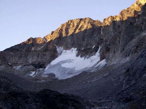
Leaving Princess Lake at the inlet, again follow a faint climbers trail that goes right next to the creek for a short while. Then it meanders through the timber, staying low in the drainage. It brings out below a meadow with Huckleberry Creek cascading down from Cold Pond. Follow the creek and then on up to Cold Pond. Now, the serious boulder hopping starts. Travel south through the boulderfield, staying low and on to the unnamed pond after Cold Lake. You can camp at the north end of the unnamed small pond in a flat gravely area with enough room for 3-4 tents. Here you will see for the first time, Granite Peak. Time permitting, I would continue on for 1-2 hours and camp at the end of Avalanche Lake. Continuing on to Avalanche Lake, you can stay low and boulder hop along the lake shore or scramble up and over the shoulder of the boulderfield, which is what's recommended. You can link a few grassy areas to get a break from the boulder hopping going this way. The higher route, going up over the shoulder, proved to be faster than following the lake. Camp at the only grassy area, at the north end of Avalanche Lake.
Leaving Avalanche Lake, work your way below and past a large rock outcropping along the south end of Avalanche Lake, then ascending the grassy slope. Above the grassy slope, work your way diagonally to the left, across the boulderfield, heading for a somewhat hidden, small, snow gully to the left of the large ridge of glacial moraine. When you reach the end of the snow gully, look up and plan a route, trying to link together the slightly grassy areas, as the rock in these areas are the most stable. Traverse along the left side of the cirque, gaining altitude, aiming for Bivouac Saddle. The lowest point on the saddle is obvious and head towards it. The last 20 vertical feet to gain the saddle will require a fun scramble up a small chimney. Now read the "South Face via East Ridge/Standard Route to reach the summit.
 Granite Peak from Peak 10328 Granite Peak from Peak 10328 |
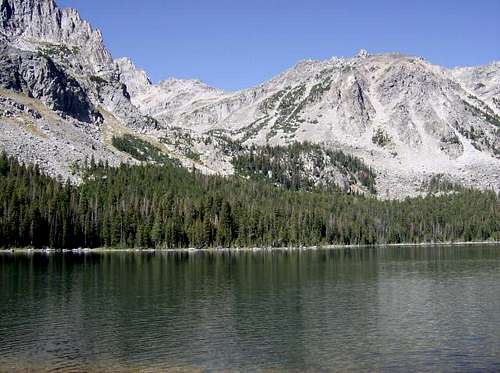 Princess Lake Princess Lake |
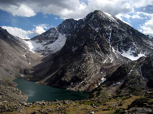
 Granite Peak from Avalanche Lake Granite Peak from Avalanche Lake |
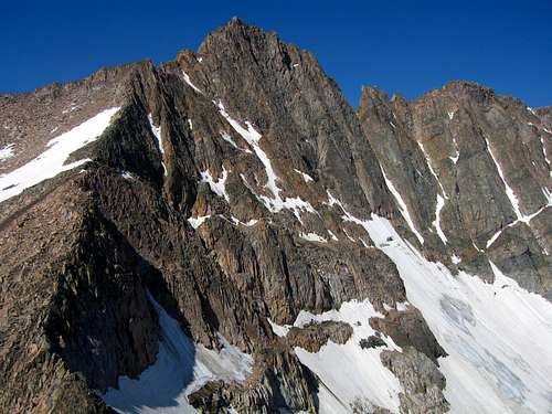 Granite Peak from the saddle Granite Peak from the saddle |
Map
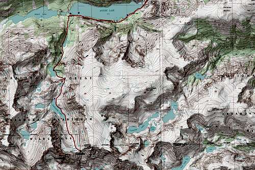 This is a map of the Huckleberry Creek approach for Granite Peak. The saddle and summit are labeled. Blue dots show great camping spots.
McCannster - Aug 21, 2018 8:19 am - Hasn't voted
Couple of notesJust returned from a successful summit bid using this approach- thanks Matt for the descriptions. A couple of things to note: -The trail from Mystic Lake to Princess Lake is generally very easy to follow. Alongside Huckleberry Lake there are a couple trivial boulderfields that are well cairned and easy to negotiate. At no point is there any true "bushwhacking". -Good camp sites can be found south of Huckleberry Lake (right before the trail begins to climb steeply up to Princess Lake), and along Princess Lake (about halfway along the lake, in between the outlet and inlet). There are also okay campsites up higher in the valley near Cold Lake, the unnnamed pond, and Avalanche Lake, but getting up there with heavy packs would be more arduous than what it's worth- up until Princess Lake the terrain and route-finding are easy to negotiate with heavy packs; after Princess Lake, it becomes a little more tricky. -Like I just mentioned, the challenges start coming after Princess Lake. We might have gone the wrong way here, but we crossed the creek at the inlet at Princess Lake and bushwhacked and then boulder-hopped up talus on the west side of the cascading waterfall creek, until we were able to find a weakness in the steep tier to surmount and gain access to Cold Lake. It appeared the east side of the creek may have been a better way to go (maybe there's actually a trail over there), we weren't sure. -There's a little bushwhacking along the west side of Cold Lake, but it isn't too bad, and passing Cold Lake goes by quick enough. Then the real talus hopping starts. -You generally want to stay low and to the west side of the drainage in between Cold Lake and Avalanche Lake, picking your way through the house-sized blocks following the path of least resistance. It's generally well-cairned through here. If visibility is low (like it was when we approached), a map and compass is essential for finding your way through this section (keep heading due south!) -As you approach Avalanche Lake, avoid ascending a rise to the east of the lake. Stay low in the drainage until you come to the lake in order to avoid going way too high too early and having to come back down to lake level. It's kind of weird because there is no creek to follow (the water is located deep down, beneath the talus, out of sight). -Bypassing Avalanche Lake isn't too bad so long as you stick near/along the eastern shoreline. Again, cairns mark the way through there. -The climb up to the saddle between Granite and Tempest is monotonous, tedious, and contains a long stretch of loose "scralus". Just put your head down and turn on auto pilot. Coming down is not as bad you may think, and we were able to boot ski down the bottom half of the glacier (it isn't all that steep), avoiding a good chuck of the scralus on the descent. Overall we enjoyed this approach to the mountain, and I think it makes the most sense to use this route if you are going Granite as an overnight (with a camp at Princess Lake). It took us 3 hours to get from W Rosebud to Princess Lake. From Princess Lake to the summit, and all the way back to W Rosebud took us 13.5 hours. Trying to hike above Princess Lake with heavy packs would suck, don't try it. For summit day, go fast and light, and start from Princess Lake. If you want to do Granite in a day, go over FTD.
Matt Lemke - Dec 25, 2018 7:25 am - Hasn't voted
Re: Couple of notesThanks for the added notes McCannster! It's been 5 years now since I did this approach so the fresh info is highly appreciated!
pcole8787 - Jan 15, 2020 8:05 am - Hasn't voted
Huckleberry Creek variation to avoid big boulders.I've not done the Cold Lake approach but I have done the Snowball Lake approach in August 2008 and it was a delightful no drama way to get to Avalanche Lake. The key was finding the faint trail up the right side of the cascading stream coming down from the Snowball Lakes drainage. After correcting for a false start too far away from the stream, I found the path and all was well. I spent the 1st night at the first Snowball lake, waited a day as a storm passed thru and on day 3 weaved my way around the Snowball Lakes keeping the small boulder hopping to a minimum. Above the last Snowball the valley opens up and is one of the nicest alpine walks I've ever done. Arriving at last at Avalanche I found a very straight forward way up onto the top of the pile and then numerous grassy leads all the way down the east side of Avalanche Lake. Then the real work began. Carrying over means you should travel light which I was, so arrived at the col and with plenty of time to spare. Decided not to bivy there and did the East Ridge that afternoon, thus avoiding the weekend crowds that were gathering at the top of the FTDP for a Saturday climb. Back at the col I traversed up to the plateau and down a ways before I found a nice quiet camp. After reaching Mystic lake the next day I realized I should have gone in and out via Huckleberry Creek. The loop gave me the full Granite experience, but if I had to do it again, I would definitely avoid the plateau and stick with Huckleberry coming and going. Its 'pros' are as mentioned while the 'cons' are minimal particularly if you go by the Snowball Lakes variation.