
|
|
Route |
|---|---|
|
|
154.00000°N / 728.00000°E |
|
|
glacier climb/ice climb |
|
|
A few days |
|
|
AD |
|
|
Approach
Start at visca Grande where you can get by bus going from Arequipa to Cotahuasi (ask the driver to drop you off) From here, traverse westwaerds some 8 kilometers until you reach a valley with mountainstream. (app 4700 m) Solimana is visible from this point. Continue upstreams until you reach a high rocky plateau set your tent here, there are some good places for high camp at a morraine rib slightly to the left in app. 5100... Watre is to be found in a stream behind the rib (to the east) during the day.
Route Description
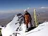
Climb the morain rib heading towards the glacier. Continue around the glacier to the right side (heading Southwest) until you find a good starting point where glacier plateau opens up. Cross the plateau and come below a narrow culoir in the NW face of the mountain (the summit in the middle is the highest one) Climnb the culoir (app 50 to 55 degrees with one or two icefalls of app 6meters up to 80 degrees) that will lead you to summit ridge. Continue by the summit ridge and reach the top. The descent is via the same route... we did the descent with our skis, see http://skicordillera.laviny.cz
 |  |  |  |
Essential Gear
you will need at least 2 icescrews and at least 3 snow anchors (persumable, you will leave one or two there when rappeling over the little icefalls). crampons, 60 m rope and two technical ice axes for the one who will lead are ok.
Miscellaneous Info
If you have information about this route that doesn't pertain to any of the other sections, please add it here.