
|
|
Mountain/Rock |
|---|---|
|
|
15.239°S / 72.641°W |
|
|
Mountaineering |
|
|
19990 ft / 6093 m |
|
|
Overview
Solimanan is a beautiful and rarely climbed remote mountain in South western Peru. It is an extinct stratovolcano that is quite eroded and what is left of the crater rim now conforms the three main summits, that are joint by a ridge in a semi-circular form. The south-west summit (lower, arround 5900m is more technical (rockclimbing required) and has first been ascended in 1973 by peruvian/italian party, the central summit (the highest one - 6093m.) is more glaciated with huge rock face from the north-west side of the mountain and requiers good glacier skills, however, it is less technical. The north summit is a bit lower than central summit and exceeds 6000m. All reports of the climbs of Solimana so far, have been published in American Alpine Journal. Counting the people who actually summited the mountain, we have been happy to be among a dozen or so people to do so. This mountain is very remote, way back from BC to civilization takes at least a day and half if you are lucky enough to catch a hike by seldomly passing busses or lorries.The remotness of the mountain, its seldom visitance, remains of Inca constructions and ruins you might find, as well as the magical contract of ice and snow with the earthy colors of altiplano stretching below make this mountain a very special place to visit...You can be sure you will be there alone.
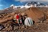
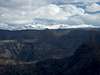
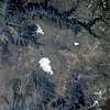
The first two pictures show view from the south, the third picture shows view from north.
 |  |  |  |  |
Getting There
Take a bus from Arequipa heading to the village named Cotahuasi, ask the driver to drop you down at Quebrada Agostura (20 km behind the Puente del rio Arma - bridge over the Arma river) if you want to climb the mountain from southern side. When we first intended to climb Solimana, we headed from the souther side and got stoped by deep canyons with quite steep walls, which made the access to the mountain quite tricky. I do not recommend this approach to anyone but those people, who have couple spare days that can be dedicated to finding the right approach. You can imagine it is not easy in a volcanic plateau with numerous valleys and canyons formed in it.The second time we went for the summit (2,5 years later) we headed from NE, which is the easiest approach to the main summit.
If you want to climb from north, get of at point called Visca Grande and from here trek westwards until you reach a path heading up to the remains of Sora village (we have not found any remains but you have to walk up a valley with little stream in it, northern views of the mountain open up for you very clearly so you can not miss it ). Maps of the region at scale 1;100000 can be got in Hidrandina - a local water office of Hidrandina should be in Arequipa(see Lonely planet). There are many shepherds paths so it is easy to lose one's way. Getting to the base of the mountain requires two days if you do not know the exact route. Local people might hire you some mules at little village called Arma but they do not know the route and this is only good for climbing from the south, which I reccomend less.
If you want to climb the lower Northern summit, it is advisable to start from Visca Grande. You will see the N summit / it is a distinguished rocky Pyramid. A traverse of all of the summits has already been done (see American Alpine journal).
 |  |  |  |  |
Red Tape
no permits, however, due to the remotness of the mountain, be sure to drop a notice at the rescue part of the peruvian national police - the section of high mountains (policia de alta montana) and let them know your returning data.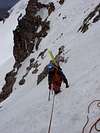 |
When To Climb
there is a wet season with storms, snow and raining from Noveber through April, better avoid this season, as it only gives you some 6 hours of climbing per day, then the storms usually move in and navigation is very tricky.Camping
Camping is possible anywhere you want, however, there are quite big and sharp stones so searching for the right place might take some time. Accessibility of drinking water mght force you to trek for water so bring enough with you for at least day and half.External Links
We have climbed and skied down Solimana in September 2004. Northern side of the mountains is composed of a large glacier plateau from which the summits rise in a semicircular form. This is a better side to climb the mountain from.
http://skicordillera.laviny.cz/?loc=13&clanek=25
for refference from our 2004 climb/ski descent of Solimana...
tatraman - Feb 23, 2004 2:12 pm - Hasn't voted
Untitled CommentI recomend Carlos Zarate as a good guide for climbing in this area. he is from a famous mountainnering company from Arequipa. and has a lot of experience. Is also helpful in providing information. Carlos is planning a climb of Solimana for April this year. He was very helpful in providing me with information for my planned ascent and ski-descent planned for august 2004.
Contact:
CARLOS ZARATE "AVENTURAS" E.I.R.L.
Calle Santa Catalina 204 Of.3
Telefono: +51-54-202461
Telefax: +51 54 263107
e-mail: carlos@zarateadventures.com
This is definitely an outfitter for Arequipa area (Ampato, Coropuna, Chachani, El Misti and others...
tatraman - Dec 6, 2004 3:17 am - Hasn't voted
Untitled CommentWe have climbed and skied down Solimana in September 2004 (see http://skicordillera.laviny.cz for more information). Northern side of the mountains is composed of a large glacier plateau from which the summits rise in a semicircular form. This is a better side to climb the mountain from.
Scott - Dec 30, 2007 7:13 pm - Hasn't voted
Correct CoordinatesCoordinates are way off. Try these: -15.239 -72.641 Adding this will make the peak appear on the interactive map.