
-
 33191 Hits
-
 75.81% Score
-
 6 Votes
|
|
Route |
|---|---|
|
|
40.07140°N / 105.6597°W |
|
|
Scramble |
|
|
A few days |
|
|
4th class |
|
|
Approach
This is usually done as a backpacking trip, although it can also be done in a very long day. Crater and Mirror Lakes, a good spot for a camp, can be approached from either the Monarch Lake Trailhead (8340') on the west (8 miles) or the Long Lake Trailhead (10,521') on the east side of the divide (9 miles). The Monarch Lake Trailhead starts at the end of the road along the south side of Lake Granby (Arapahoe Bay Road).
Follow the Buchanan Creek Trail, turn right up the Cascade Creek Trail, and finally make another right to Crater Lake. For the eastern approach, find the Long Lake Trailhead at the sprawling Brainard Lake area near Ward, CO ($7 user fee). This parking lot fills up on the weekends. Follow the signs for Pawnee Pass and cross the Continental Divide (~12,500' and higher than the summit of Lone Eagle), drop down a very steep trail to Pawnee Lake, and after a couple more miles turn onto the trail to Crater Lake.
For any overnight camping in the Indian Peaks, a backcountry permit from the National Forest Service is required from June 1 to Sept. 15. These can be purchased at either the Forest Service offices in Granby or Boulder, at the Ace Hardware in Nederland, or at the Monarch Lake Trailhead. Here's some contact information I copied from their website:
| Boulder Ranger District USDA Forest Service 2140 Yarmouth Ave. Boulder, CO 80301 (303) 541-2500 Mon-Fri 8-4:30 |
Monarch Lake Wilderness Station 8-5, 7 days a week (tentative) during summer |
| Indian Peaks Ace Hardware 74 Hwy. 119 South (West side of 119) Nederland, CO 80466 (303) 258-3132 8 am - 7 pm Mon-Sat 9 am - 5 pm Sundays DAY-OF-TRIP PERMITS ONLY |
Sulphur Ranger District USDA Forest Service 9 Ten Mile Drive P.O. Box 10 Granby, CO 80446 (970) 887-4100 Mon-Fri 8-4:30 |
Camping in the "Crater Lake Backcountry Zone" is in designated sites only, and these are often full in the summer. Reservations for summer weekends would be recommended. If all the sites are taken, it is also feasible to camp in the "Cascade Creek Backcountry Zone".
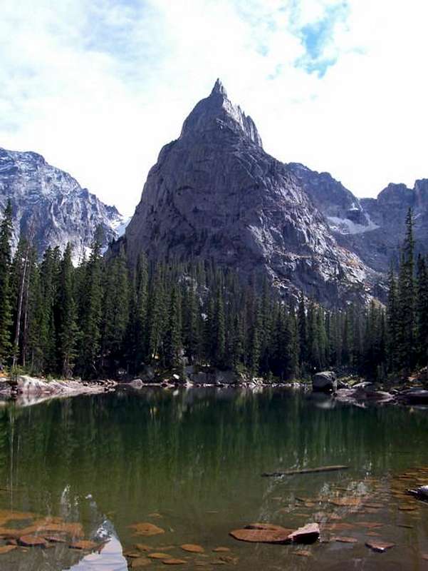 Lone Eagle as viewed from Mirror Lake, which is along the approach.
Route Description
This is the standard descent route and is the popular "peakbagging" route as well since this provides the easiest route to the summit. While the amazing view from Mirror Lake gives the illusion that this should be a much more difficult summit to reach, this route is primarily hiking along grassy ledges with a few spots of exposed scrambling. From Crater Lake, plan for about 3 hours to reach the top.
Work around the east side of Mirror and Crater Lakes following the marked trail to campsites #7 & 8 and continue until you encounter a clearing where the vertical north face of Lone Eagle meets Crater Lake. Hike several hundred feet up the steep grass and talus to the left (northeast) of this face and follow a faint trail marked with cairns about a half mile along the edge of this face. When you reach a saddle above Triangle Lake (the first time this lake is visible), turn right (west) and begin climbing up through the cliffs on grass and boulders.
Continue working up, with a little scrambling until you reach a grassy ledge system where you can see a continuous path to a notch in the ridge on the right. Turn right and follow this to the notch. From here the summit is visible to the north and below. The first tower on the ridge can be bypassed by dropping to the west side of the ridge and traversing to the next notch to the north. Cross onto the east side of the ridge by crawling under (or over) a huge chockstone in the notch. Begin traversing north again and generally trending down with a few exposed moves.
There are probably several ways to do this, but most traverse on this ledge system until it ends, then sling a large block, and rappel about 50 ft down to another ledge. Reclimbing this on the return is fourth or easy fifth class (with long fall potential) if you pull your rope, otherwise just ascend the rope.
Alternately, our party actually traversed below the rappel on a series of thin ledges and didn't use a rope since we bypassed the rappel. This was a very exposed traverse.
Either way, from the ledge mentioned ledge traverse south a little until it is possible to scramble down to the next huge, obvious ledge. Begin an ascending traverse north towards the now-visible summit. The last bit is fun scrambling on very solid granite flakes that provide nice positive holds. Upon reaching the top of the last visible tower, you can follow a 3 ft wide ledge north about a dozen yards to an amazing seat at the end of the ridge. There is a summit register in the little pocket just before this. The "summit" isn't the highest point, but the northernmost point on the ridge.
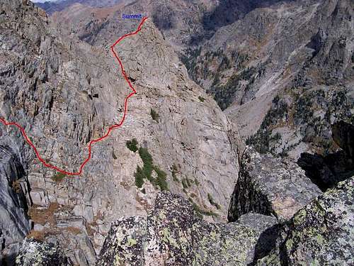 Approximate route of Solo Flight, though the far left might be slightly off?
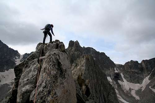 Summit of Lone Eagle.
Essential Gear
Standard overnight backpacking gear for the approach. Although the approach follows well-defined trails, a topo map would still be recommended. The Trails Illustrated #102: Indian Peaks/Gold Hill is very nice. For the climb, a helmet, rope, harness, and a light rack would probably be a good idea. We had a 60 m rope, but a 30 m might still work for the rap we did and cut the rope weight in half for the approach.