-
 5507 Hits
-
 74.01% Score
-
 4 Votes
|
|
Route |
|---|---|
|
|
43.88970°N / 114.6028°W |
|
|
Hiking, Mountaineering, Scrambling, Skiing |
|
|
Spring, Summer, Fall, Winter |
|
|
Half a day |
|
|
Class 3 |
|
|
Overview
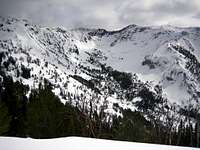
The Southwest Ridge of Galena Peak makes an excellent winter climb. The Galena Peak / Galena Summit area is a popular destination for backcountry skiers and snow-shoe enthusiasts. The groomed trails around Galena Lodge are excellent for cross country skiing, but also provide easy access to the climbing on Galena Peak's southwest ridge. This route basically follows the prominent ridgeline and is most often safe, but there are sections where loose snow and rock may present some hazards. If done in the summer, this route is nothing more than a steep, straight-forward scramble.

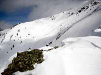
From the parking area just south of Galena Lodge, find the groomed trail on the east side of ID-75, and follow that into the beautiful Senate Meadows. From Senate Meadows follow a series of connecting groomed cross country trails toward the base of Pt 9824. Leave the groomed trails at the highest point on the black trail, or follow seasonal ski trails just north of here. Your first objective is getting to Pt 9824. Ascend the steep west slopes just north of upper N Cherry Creek. If breaking trail, this section can be difficult and time consuming. Look for existing skier skin trails that will most likely take you onto Pt 9824. From 9824, the slopes ease as you ascend to the "Mines" as marked on the USGS map. Near here is a prominent saddle with steep slopes and wind blown cornices most likely on the southeast side of this ridge.
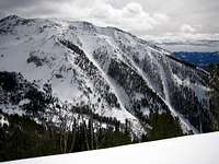
From the small saddle, the slope steepens as it ascends a particularly rocky section of the ridge. This area is most likely the crux, and depending on the conditions (highly variable), either go directly up the rock rib or traverse out onto the open slopes to ascend to higher territory. Above this, the slope eases again to the summit ridge. Easley Peak is visible to the south, and the Titus ridgeline dominates the west view.
Southwest Ridge via Senate Meadows: 4.4 miles and 4202 feet gain (one way)